
Schmidgaden
| coat of arms | Germany map | |
|---|---|---|

|
Coordinates: 49 ° 25 ' N , 12 ° 6' E |
|
| Basic data | ||
| State : | Bavaria | |
| Administrative region : | Upper Palatinate | |
| County : | Schwandorf | |
| Height : | 387 m above sea level NHN | |
| Area : | 41.24 km 2 | |
| Residents: | 2948 (Dec. 31, 2019) | |
| Population density : | 71 inhabitants per km 2 | |
| Postal code : | 92546 | |
| Area code : | 09435 | |
| License plate : | SAD, BUL , NAB , NEN, OVI, ROD | |
| Community key : | 09 3 76 159 | |
| LOCODE : | DE XSG | |
| Community structure: | 18 districts | |
| Address of the municipal administration: |
Schwarzenfelder Weg 9 92546 Schmidgaden |
|
| Website : | ||
| Mayor : | Josef Deichl ( Schmidgaden municipality ) | |
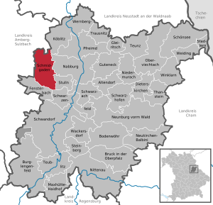
| Location of the community Schmidgaden in the district of Schwandorf | ||
  |
||


Schmidgaden is a municipality in the Upper Palatinate district of Schwandorf .
geography
Schmidgaden is 17 kilometers north of Schwandorf in the Upper Palatinate North region . Regensburg is 57 kilometers away , Nuremberg 89 kilometers by road.
Districts
The community Schmidgaden consists of the main town and the following 17 districts:
There are the districts Schmidgaden, Trisching, Wolfsbach, Rottendorf, Gösselsdorf and Littenhof.
history
Until the church is planted
A gentleman from Schmidgaden was first mentioned in a document in 1123 under the Diepolding Landgraves . The meaning of the name is not entirely clear; it could be derived from Schmiede . A blacksmith would have been the first landlord . Schmidgaden was already a parish in 1326, as can be seen from records of the Diocese of Regensburg .
In the Thirty Years War , Schmidgaden's population was halved. Between 1576 and 1648 the residents changed their faith four times. In 1795/96 Austrian, French and Prussian troops crossed the area during the coalition war . The place belonged to the Amberg Rent Office and the Nabburg Regional Court of the Electorate of Bavaria . In the course of the administrative reforms in Bavaria , today's political municipality was created with the municipal edict of 1818 .
20th century
In 1917, lignite mining began in Schmidgaden. The United Union of Schmidgaden-Schwarzenfeld produced around 17,500 tons a year in 1920 and had 660 employees. In 1923, however, operations were stopped. In June 1937, Annawerk A. G. from Oeslau took over the mining works of the United Union. In November 1937 the Annawerk A. G. founded the Buchtal AG , ceramic operations of the Reichswerke Hermann Göring with headquarters in Schwarzenfeld, together with the Reichswerke Hermann Göring AG . The newly established company had the Kuxe of the United Union and a forced labor camp with about 750 people.
In 1935 Schmidgaden was connected to the electrical power grid.
Incorporations
On January 1, 1972, the communities Rottendorf , Trisching and parts of Gösselsdorf were incorporated into Schmidgaden.
Population development
Between 1988 and 2018 the municipality grew from 2,478 to 2,955 by 477 inhabitants or 19.3%.
- 1961: 1932 inhabitants
- 1970: 2265 inhabitants
- 1987: 2421 inhabitants
- 1991: 2547 inhabitants
- 1995: 2692 inhabitants
- 2000: 2782 inhabitants
- 2005: 2928 inhabitants
- 2010: 2892 inhabitants
- 2015: 2879 inhabitants
- 2016: 2931 inhabitants
- 2017: 2917 inhabitants
- 2018: 2955 inhabitants
- 2019: 2954 inhabitants
politics
Municipal council
The municipal council consists of 14 councilors and the first mayor.
The local election of March 16, 2014 resulted in the following distribution of seats in the Schmidgaden municipal council:
| CSU | SPD | Common good | FW Rott.-Göss. | FWG Trisching |
|---|---|---|---|---|
| 2 seats | 2 seats | 4 seats | 3 seats | 3 seats |
mayor
Josef Deichl from the community of Schmidgaden voters won the 2014 mayoral election with 54.07 percent (1024 votes) compared to 45.93 percent (870 votes) of his predecessor Rudolf Birner from the FW Rottendorf-Gösselsdorf group of voters.
The office of mayor will be full-time from the 2020 electoral term. A referendum on November 24, 2019 confirmed this decision by the municipal council. For a community the size of Schmidgaden, this is a novelty in the Schwandorf district.
coat of arms
Blazon : Under a red shield head, inside a silver scythe leaf, in silver on a corrugated green base a green beech. Coat of arms since 1965. The municipal coat of arms indicates the Schmidgaden family. The colors white and red are reminiscent of the noble family of Paulsdorf .
Culture and sights

The Catholic parish church of the Assumption of Mary in Schmidgaden has developed from a former castle chapel from the 14th century. The former field name "Burgstall" and the remains of the wall at the cemetery speak for it. The castle, which no longer exists today, would then have fallen into disrepair after the Schmidgaden gentlemen had given it up. To the east of the church is an octagonal tower. Under the octagonal tower is the oldest part of the church, today's baptistery. Two bells date from the 15th century, but were re-cast in 1961. A third bell was produced in 1790. Extensive renovations were carried out on the church in the 1950s. The Paulsdorfer's coat of arms stone was discovered during construction work . In 1993 a new organ was handed over to the parish. The northern cemetery wall was partially built in the 18th century. Every weekend after August 15th, the patronage of the Parish Church of the Assumption, a parish is celebrated.
The Monument Via Carolina sculpture was unveiled in 2008.
Economy and Infrastructure
According to official statistics, there were 377 employees at the workplace in 2014. Of these, 272 in the manufacturing sector and 27 in the trade, transport and hospitality sector, are subject to social security contributions . In the public and private service sector, 38 people were employed at the place of work subject to social security contributions. There were a total of 1236 employees at the place of residence subject to social security contributions.
In the construction sector , there were 2,015 farms in four years.
While in 1999 there were still 121 agricultural holdings with an agriculturally used area of 1929 hectares, of which 1467 hectares were arable land and 452 hectares of permanent green space , the number of farms fell to 71 in 2010.
The number of unemployed in 2015 was 32 and thus a rate of 2.5%, which is well below the average for the Free State of Bavaria and the district of Schwandorf .
Schmidgaden has its own exit (AS 68) on the A 6 motorway (Nuremberg – Prague). The A 93 (Hof-Regensburg) runs 8 kilometers to the east.
There is Schmidgaden airfield ( ICAO code EDPQ) for helicopters , motor gliders and gliders . The special landing site is used by Aero-Club Schmidgaden e. V.
In 2017 there were the following institutions:
- Kindergartens: 107 kindergarten places with 97 children
- Primary school: One with 46 students
- Middle School: One with 63 students and 8 teachers
Personalities
Web links
- Web presence of the community Schmidgaden
- Schmidgaden: Official statistics of the LfStat
- Entry on the Schmidgaden coat of arms in the database of the House of Bavarian History
Individual evidence
- ↑ "Data 2" sheet, Statistical Report A1200C 202041 Population of the municipalities, districts and administrative districts 1st quarter 2020 (population based on the 2011 census) ( help ).
- ↑ Information from the Bavarian State Library
- ↑ Elisabeth Müller-Luckner: Nabburg (= Historical Atlas of Bavaria , part of Altbayern, Series 1: Districts / Regional Courts, Issue 50), published by the Commission for Bavarian State History at the Bavarian Academy of Sciences. Commission for Bavarian State History, Munich 1981, ISBN 3-7696-9915-7 , p. 46
- ↑ Winfried Nerdinger (ed.): Building in National Socialism. Bayern 1933-1945 , Munich 1993, p. 536. ISBN 3-7814-0360-2 .
- ^ Wilhelm Volkert (ed.): Handbook of Bavarian offices, communities and courts 1799–1980 . CH Beck, Munich 1983, ISBN 3-406-09669-7 , p. 530 .
- ↑ schmidgaden.de , result of the municipal council elections
- ↑ http://wahlen.landkreis-schwandorf.de/2014/Buergermeisterwahl/buergermeister.html. Retrieved April 15, 2017 .
- ^ The art monuments of Upper Palatinate and Regensburg: District Office Nabburg . Oldenbourg Wissenschaftsverlag, Munich 1983, ISBN 3-486-50448-7 . Page 103 ff.
- ^ Statistics of the Bavarian municipalities. (No longer available online.) Archived from the original on October 5, 2017 ; accessed on October 5, 2017 . Info: The archive link was inserted automatically and has not yet been checked. Please check the original and archive link according to the instructions and then remove this notice.
- ^ Municipalities in Bavaria. (No longer available online.) Archived from the original on October 5, 2017 ; accessed on October 5, 2017 . Info: The archive link was inserted automatically and has not yet been checked. Please check the original and archive link according to the instructions and then remove this notice.
- ^ Schools in Schmidgaden
- ↑ Home. Retrieved April 15, 2017 .

Altendorf | Bodenwohr | Bruck in the Upper Palatinate | Burglengenfeld | Dieterskirchen | Fensterbach | Slip | Guteneck | Maxhütte-Haidhof | Nabburg | Neukirchen-Balbini | Neunburg vorm Wald | Niedermurach | Nittenau | Oberviechtach | Pfreimd | Schmidgaden | Schönsee | Schwandorf | Schwarzach near Nabburg | Schwarzenfeld | Schwarzhofen | Stadlern | Steinberg am See | Stulln | Teublitz | Teunz | Thanstein | Trausnitz | Wackersdorf | Weiding | Wernberg-Koeblitz | Winklarn
Unregulated areas: Wolferlohe