
Guteneck
| coat of arms | Germany map | |
|---|---|---|

|
Coordinates: 49 ° 27 ' N , 12 ° 16' E |
|
| Basic data | ||
| State : | Bavaria | |
| Administrative region : | Upper Palatinate | |
| County : | Schwandorf | |
| Management Community : | Nabburg | |
| Height : | 461 m above sea level NHN | |
| Area : | 35.08 km 2 | |
| Residents: | 819 (Dec. 31, 2019) | |
| Population density : | 23 inhabitants per km 2 | |
| Postal code : | 92543 | |
| Primaries : | 09433, 09675 | |
| License plate : | SAD, BUL , NAB , NEN, OVI, ROD | |
| Community key : | 09 3 76 133 | |
| LOCODE : | DE UTE | |
| Community structure: | 14 districts | |
| Address of the municipal administration: |
Schloßberg 1 92543 Guteneck |
|
| Website : | ||
| Mayor : | Johann Wilhelm ( CSU ) | |
| Location of the community Guteneck in the district of Schwandorf | ||
  |
||


Guteneck is a municipality in the Upper Palatinate district of Schwandorf .
geography
The capital of the same name is located in the Oberpfalz-Nord region , seven kilometers east of the A 93 motorway on the rocky west bank high above the Katzbach, which flows into the Schwarzach about three kilometers further south at Willhof .
Community structure
The community consists of 14 districts:
There are the districts Guteneck, Pischdorf and Unteraich.
history
Until the church is planted
The place, first mentioned in 1147, was part of the Electorate of Bavaria and formed a closed Hofmark , which had been in the possession of the Counts of Kreuth since 1576. In the course of the administrative reforms in Bavaria , the municipality was created with the municipal edict of 1818 .
lock
In the 13th century, today's Guteneck Castle was preceded by a Gothic castle complex, over which a castle was later built. From 1272 to 1574 it was owned by the Lords of Murach and from 1570 to 1893 by the Counts of Kreith. The castle burned down completely in a village fire in 1822. At first only the chapel and the castle building connected to it were rebuilt. Count Franz von Spreti built a residential wing on medieval foundations in 1894, using remnants of the baroque wall. The current owners, Count Beissel von Gymnich, offer holiday apartments in the castle. The castle chapel is popular for weddings.
Incorporations
On January 1, 1972, the previously independent communities of Pischdorf and Unteraich were incorporated. On May 1, 1978, small parts of the dissolved Hohentreswitz community were added.
Population development
| year | 1961 | 1970 | 1987 | 1991 | 1995 | 2000 | 2005 | 2010 | 2015 |
| Residents | 1005 | 998 | 914 | 887 | 876 | 892 | 879 | 877 | 831 |
Politics and Public Administration
The community is a member of the Nabburg administrative community .
The first mayor is Johann Wilhelm (CSU).
coat of arms
|
|
Blazon : "Under a silver shield head with three red arcade arches tinned on top, a silver plow in green over a golden three-mountain."
since 1982 |
Culture and sights
- Medieval town center around Guteneck Castle
- Parish Church of St. Michael in Weidenthal
- Historic romantic Christmas market on the Advent weekends at Guteneck Castle; additionally since 2012 garden days (weekend in April)
- Castle chapel at Guteneck Castle
- Baderkapelle
- Lourdes grotto
- The Franconian Way of St. James comes from Oberkatzbach , two kilometers to the east , and is marked with a white shell on a light blue background. The next stop on the Franconian Way of St. James is the umbrella village four kilometers south of Guteneck .
Economy and Infrastructure
Economy including agriculture and forestry
In 1998, according to official statistics, there were 25 in the manufacturing industry and no employees subject to social security contributions at the place of work in the trade and transport sector. There were 262 employees at the place of residence subject to social security contributions. There was one in the manufacturing sector and three in the construction sector. In addition, in 1999 there were 106 farms with an agricultural area of 2037 ha, of which 1605 ha were arable land.
education
In 1999 the following institutions existed:
- A primary school with three teachers and 61 students
Sports
- SF Weidenthal / Guteneck
- Hubertus-Schützen-Guteneck
Personalities
The owners of Guteneck Castle are the Count Beissel von Gymnich .
annotation
The Guteneck rule (Gutenegkh, Slov. Gotnik) with the castle of the same name - once part of the Duchy of Carniola , today Slovene territory - was a fiefdom of the Patriarchate of Aquileja in the Middle Ages .

Fire station Guteneck (2017)
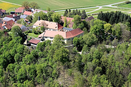
Guteneck Castle (2017)

Baderkapelle (2017)


literature
- Fränkischer Albverein (Ed.): On the Jakobsweg from Tillyschanz via Schwandorf to Nuremberg . Verlag Seehars, Uffenheim 1997, ISBN 3-927598-22-4
Web links
Individual evidence
- ↑ "Data 2" sheet, Statistical Report A1200C 202041 Population of the municipalities, districts and administrative districts 1st quarter 2020 (population based on the 2011 census) ( help ).
- ↑ http://www.bayerische-landesbibliothek-online.de/orte/ortssuche_action.html ? Anzeige=voll&modus=automat&tempus=+20111207/234401&attr=OBJ&val= 1049
- ^ Fränkischer Albverein (Ed.): On the Way of St. James from Tillyschanz via Schwandorf to Nuremberg . Verlag Seehars, 97215 Uffenheim 1997, ISBN 3-927598-22-4 , p. 26
- ^ Wilhelm Volkert (ed.): Handbook of Bavarian offices, communities and courts 1799–1980 . CH Beck, Munich 1983, ISBN 3-406-09669-7 , p. 530 .
- ^ Federal Statistical Office (ed.): Historical municipality directory for the Federal Republic of Germany. Name, border and key number changes in municipalities, counties and administrative districts from May 27, 1970 to December 31, 1982 . W. Kohlhammer GmbH, Stuttgart / Mainz 1983, ISBN 3-17-003263-1 , p. 668 .
- ↑ Administration. Guteneck community, accessed on August 9, 2020 .
- ^ Entry on Guteneck's coat of arms in the database of the House of Bavarian History
- ^ Fränkischer Albverein (Ed.): On the Way of St. James from Tillyschanz via Schwandorf to Nuremberg. Verlag Seehars, 97215 Uffenheim 1997, ISBN 3-927598-22-4 , pp. 26, 27

Altendorf | Bodenwohr | Bruck in the Upper Palatinate | Burglengenfeld | Dieterskirchen | Fensterbach | Slip | Guteneck | Maxhütte-Haidhof | Nabburg | Neukirchen-Balbini | Neunburg vorm Wald | Niedermurach | Nittenau | Oberviechtach | Pfreimd | Schmidgaden | Schönsee | Schwandorf | Schwarzach near Nabburg | Schwarzenfeld | Schwarzhofen | Stadlern | Steinberg am See | Stulln | Teublitz | Teunz | Thanstein | Trausnitz | Wackersdorf | Weiding | Wernberg-Koeblitz | Winklarn
Unregulated areas: Wolferlohe
Rock mill | Guteneck | Häuslberg | Luigendorf | Maximilianshof | Mitteraich | Oberaich | Oberkatzbach | Pischdorf | Trefnitz | Trichenricht | Unteraich | Unterkatzbach | Weidenthal