
Pischdorf (Guteneck)
|
Pischdorf
community Guteneck
Coordinates: 49 ° 27 ′ 40 ″ N , 12 ° 18 ′ 24 ″ E
|
||
|---|---|---|
| Height : | 480 m | |
| Incorporation : | January 1, 1972 | |
| Postal code : | 92543 | |
| Area code : | 09675 | |
Location of Pischdorf in Bavaria |
||
 Pischdorf (2016)
|
||

Pischdorf is a district of the Guteneck community in the Schwandorf district .
geography
Pischdorf is located about 20 km west of the border with the Czech Republic in the central Upper Palatinate Forest , about 2 km northeast of Guteneck at an altitude of 480 meters. The place can be reached via the district roads SAD 38.
from history
Pischdorf settlement
Slavic place names such as Gleiritsch , Hohentreswitz or Trefnitz document an early settlement of the area around the Kulm near Pischdorf. In a further settlement phase, the focus of which was in the 10th and 11th centuries, a number of village locations such as Pamsendorf , Fuchsendorf or Altendorf were created , which were followed by Richt locations and Ried locations such as Trichenricht , Lampenricht or Zeinried .
Ownership history
The brothers Pruno, Ludewicus and Rudegerus von Willhof donated their share of an estate that they owned in Pischdorf (Pisschofesdorf) to the Reichenbach monastery around 1150 . Irinfrid von Swerzinfelt (Schwarzenfeld) received the possessions at Pischdorf. He passed it on to Reginger von Tännesberg for administration. From the 14th century, the Murach family took over the possessions in Pischdorf. Jordan von Murach received the Vogtei Weidenthal and Pischdorf as a fief on June 10, 1315. In 1524 Albrecht von Murach took over the Vogtei Pischdorf in addition to the Vogtei Weidenthal. He exercised military protection and was responsible for the judiciary.
Thirty Years' War
The Thirty Years' War from 1618 to 1648 was a conflict over supremacy in the Holy Roman Empire of the German Nation and in Europe and at the same time a religious war that also reached the Upper Palatinate in 1621 and had devastating economic, social and cultural effects. The Nabburg office, to which Pischdorf belonged, was also badly affected. Robbery, fire and looting terrified the people and the livestock were greatly reduced. Epidemics and famines decimated the population in the Nabburg district by around 40 percent during this time. The residents of Nabburg and the surrounding villages had to pay for the war costs. In the years 1628 to 1651, Pischdorf had to bear war expenses in the amount of 1057 guilders.
Church building
The Kingdom of Bavaria was divided into 15 districts in 1808. These districts were named after rivers based on the French model ( Naabkreis , Regenkreis , Unterdonaukreis ). The districts were divided into district courts. The districts in turn should be divided into individual municipality areas. In 1811 the district court of Nabburg was divided into 58 chairmen, a lowest administrative unit that corresponds to a municipality. One of them was Unteraich, consisting of the villages Unteraich, Mitteraich, Oberaich, Pischdorf, Guteneck, Oberkatzbach, Häuslberg and Maximilianshof. According to the municipal edict of 1818, there was a list of the existing municipalities in the Nabburg district court on June 14, 1819. The community Pischdorf consisted of the localities Pischdorf with 45 families and the wasteland Maximilianshof with three families. In 1842 26 families lived in Pischdorf. The population was 194. Two families with a total of seven people lived at Maximilianshof.
Dissolution of the community of Pischdorf
On January 1, 1972, the municipality of Pischdorf was dissolved and incorporated into the municipality of Guteneck.
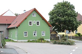
Picture gallery

Pischdorf (2016)

Pischdorf (2016)

St. Stephan (2016)
Pischdorf (2016)

Village Cross (2016)
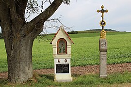
Wayside shrine (2016)


Individual evidence
- ↑ Alois Köppl: From the history of the community Gleiritsch . P. 33
- ↑ Elisabeth Müller-Luckner: Historical Atlas of Bavaria, part of Old Bavaria . Booklet 50, Nabburg, p. 34
- ↑ Elisabeth Müller-Luckner: Historical Atlas of Bavaria, part of Old Bavaria . Book 50, Nabburg, p. 174
- ↑ State Archives Amberg, Loyalty Documents Oberpfalz, No. 21402
- ↑ Elisabeth Müller-Luckner: Historical Atlas of Bavaria, part of Old Bavaria . Book 50, Nabburg, p. 85
- ↑ Elisabeth Müller-Luckner: Historical Atlas of Bavaria, part of Old Bavaria . Book 50, Nabburg, p. 87
- ^ Ernst Emmering: The government of the Upper Palatinate, history of a Bavarian central authority . Contributions to the history and regional studies of the Upper Palatinate, issue 20, Regensburg 1981, p. 12 ff.
- ↑ Elisabeth Müller-Luckner: Historical Atlas of Bavaria, part of Old Bavaria . Booklet 50, Nabburg, Nabburg, p. 407
- ↑ State Archives Amberg, Regional Court of the Older Order, Nabburg, No. 1179
- ↑ Elisabeth Müller-Luckner: Historical Atlas of Bavaria, part of Old Bavaria . Book 50, Nabburg, p. 415
- ↑ Elisabeth Müller-Luckner: Historical Atlas of Bavaria, part of Old Bavaria . Booklet 50, Nabburg, p. 427
- ↑ Elisabeth Müller-Luckner: Historical Atlas of Bavaria, part of Old Bavaria . Book 50, Nabburg, p. 436
literature
- Alois Köppl: From the history of the community Gleiritsch . Gleiritsch 1988
- Elisabeth Müller-Luckner: Historical Atlas of Bavaria, part of Old Bavaria . Issue 50, Nabburg, Munich 1981, ISBN 3-7696-9915-7
- Amberg State Archives, Fiefdoms Upper Palatinate, No. 21402
- Ernst Emmering: The government of the Upper Palatinate, history of a Bavarian central authority . Contributions to the history and regional studies of the Upper Palatinate, issue 20, Regensburg 1981
Web links

Rock mill | Guteneck | Häuslberg | Luigendorf | Maximilianshof | Mitteraich | Oberaich | Oberkatzbach | Pischdorf | Trefnitz | Trichenricht | Unteraich | Unterkatzbach | Weidenthal