
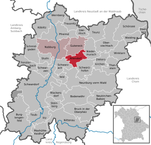
Altendorf (district of Schwandorf)
| coat of arms | Germany map | |
|---|---|---|
.svg)
|
Coordinates: 49 ° 24 ' N , 12 ° 17' E |
|
| Basic data | ||
| State : | Bavaria | |
| Administrative region : | Upper Palatinate | |
| County : | Schwandorf | |
| Management Community : | Nabburg | |
| Height : | 376 m above sea level NHN | |
| Area : | 23.16 km 2 | |
| Residents: | 852 (Dec. 31, 2019) | |
| Population density : | 37 inhabitants per km 2 | |
| Postal code : | 92540 | |
| Area code : | 09675 | |
| License plate : | SAD, BUL , NAB , NEN, OVI, ROD | |
| Community key : | 09 3 76 112 | |
| Community structure: | 12 districts | |
| Address of the municipal administration: |
Kirchsteig 14 92540 Altendorf |
|
| Website : | ||
| First Mayor : | Georg Köppl | |
| Location of the community Altendorf in the district of Schwandorf | ||
  |
||


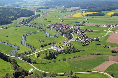
Altendorf is a municipality in the Upper Palatinate district of Schwandorf and a member of the Nabburg administrative community .
geography
The community is located in the Upper Palatinate North region , nine kilometers southeast of the city of Nabburg on the Schwarzach River . The state road from Nabburg to Neunburg vorm Wald runs through Altendorf.
Community structure
The municipality consists of the following twelve officially named districts:
|
There are the districts Altendorf, Dürnersdorf, Willhof and Fronhof.
history
Until the church is planted
Altendorf was first mentioned in 1118. In that year Erchinbertus de Altindorf appeared as a witness at the margravial donation of the Reichenbach estate to the Reichenbach monastery . The name could be derived from the adjective old as well as from the personal name Alto . Altendorf was the official seat before 1800 and belonged to the Amberg Rent Office and the Nabburg Regional Court of the Electorate of Bavaria . Caspar Bernclau Freiherr von Schönreuth owned a country estate here with lower jurisdiction . In the course of the administrative reforms in Bavaria , the municipality was created with the municipal edict of 1818 .
Incorporations
On January 1, 1972, the previously independent community of Willhof was incorporated. On July 1, 1972 Dürnersdorf and Fronhof were added.
Population development
Between 1988 and 2018, the population decreased from 970 to 855 by 115 inhabitants or 11.9%.
- 1961: 1063 inhabitants
- 1970: 1066 inhabitants
- 1987: 992 inhabitants
- 1991: 976 inhabitants
- 1995: 1014 inhabitants
- 2000: 978 inhabitants
- 2005: 947 inhabitants
- 2010: 951 inhabitants
- 2015: 891 inhabitants
coat of arms
Blazon : Divided: divided above three times by black and gold; below, in red over golden four-mountain, a floating, horizontal, silver hunting horn.
History of the coat of arms : The coat of arms was awarded by a ministerial decision of November 12, 1968. It refers to the seat of various noble families in the place. The threefold division above symbolizes the Barons von Schellenberg . The Hifthorn, on the other hand, stands for the noble Horneck von Hornberg family . The Vierberg im Schildfuß comes from the coat of arms of the Counts of Leonberg , who called themselves Leonberg-Altenbach as the successors of the Bavarian Counts of Altendorf .
Economy and Infrastructure
Economy including agriculture and forestry
The municipal tax revenue amounted to 395 T € in 1999, of which 131 T € (net) was trade tax income.
In 1998 there were no employees in agriculture and forestry, none in manufacturing and 47 in trade and transport at the place of work. In other economic sectors, 23 people were employed at the place of work subject to social security contributions. There were a total of 345 employees at the place of residence subject to social security contributions. There were no companies in the manufacturing sector and three companies in the main construction sector. In addition, in 1999 there were 48 farms with an agriculturally used area of 1200 ha. 865 ha of this was arable land.
traffic
The Altendorf (b Nabburg) station on the former Nabburg – Schönsee railway line has been closed.
education
In 1999 the following institutions existed:
- Kindergartens: 50 kindergarten places with 46 children
- Primary schools: one with two teachers and 68 students
Architectural monuments
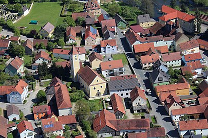
Parish Church of St. Andreas (2017)
Umbrella village (2017)

Local government

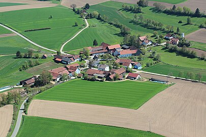
Fronhof (2013)
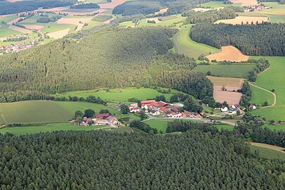
Oberkonhof (2012)
Willhof (2017)


literature
- Wilhelm Nutzinger: Historical Atlas of Bavaria, Part of Old Bavaria , Issue 52, Neunburg vorm Wald, Munich 1982, ISBN 3-7696-9928-9 .
- Elisabeth Müller-Luckner: Historical Atlas of Bavaria, part of Old Bavaria , Issue 50, Nabburg, Munich 1981, ISBN 3-7696-9915-7 .
- Karl-Otto Ambronn: Historical Atlas of Bavaria, Part of Old Bavaria , Series II, Book 3, Landsassen and Landsassengüter of the Principality of the Upper Palatinate in the 16th century, Munich 1982, ISBN 3-7696-9932-7 .
- Richard Hoffmann, Felix Mader: Art Monuments of the Kingdom of Bavaria, The Art Monuments of Upper Palatinate and Regensburg , District Office Nabburg, Munich 1910.
Web links
- Homepage
- Entry on the coat of arms of Altendorf (Schwandorf district) in the database of the House of Bavarian History
- Altendorf (district of Schwandorf): Official statistics of the LfStat
- History of the Altendorf community (VG Nabburg)
Individual evidence
- ↑ "Data 2" sheet, Statistical Report A1200C 202041 Population of the municipalities, districts and administrative districts 1st quarter 2020 (population based on the 2011 census) ( help ).
- ^ Altendorf community: Greetings from the mayor. Retrieved May 13, 2020 .
- ↑ http://www.bayerische-landesbibliothek-online.de/orte/ortssuche_action.html ? Anzeige=voll&modus=automat&tempus=+20111207/223224&attr=OBJ&val= 1042
- ^ Wilhelm Volkert (ed.): Handbook of Bavarian offices, communities and courts 1799–1980 . CH Beck, Munich 1983, ISBN 3-406-09669-7 , p. 529 .
- ↑ a b House of Bavarian History - Bavaria's municipalities. Retrieved August 13, 2019 .

Altendorf | Bodenwohr | Bruck in the Upper Palatinate | Burglengenfeld | Dieterskirchen | Fensterbach | Slip | Guteneck | Maxhütte-Haidhof | Nabburg | Neukirchen-Balbini | Neunburg vorm Wald | Niedermurach | Nittenau | Oberviechtach | Pfreimd | Schmidgaden | Schönsee | Schwandorf | Schwarzach near Nabburg | Schwarzenfeld | Schwarzhofen | Stadlern | Steinberg am See | Stulln | Teublitz | Teunz | Thanstein | Trausnitz | Wackersdorf | Weiding | Wernberg-Koeblitz | Winklarn
Unregulated areas: Wolferlohe
Altendorf | Dürnersdorf | Fronhof | Marklhof | Murglhof | Oberkonhof | Umbrella village | Siegeldorf | Stabhof | Trossau | Unterkonhof | Willhof