Trausnitz
| coat of arms | Germany map | |
|---|---|---|

|
Coordinates: 49 ° 31 ' N , 12 ° 16' E |
|
| Basic data | ||
| State : | Bavaria | |
| Administrative region : | Upper Palatinate | |
| County : | Schwandorf | |
| Management Community : | Pfreimd | |
| Height : | 448 m above sea level NHN | |
| Area : | 17.63 km 2 | |
| Residents: | 965 (Dec. 31, 2019) | |
| Population density : | 55 inhabitants per km 2 | |
| Postal code : | 92555 | |
| Area code : | 09655 | |
| License plate : | SAD, BUL , NAB , NEN, OVI, ROD | |
| Community key : | 09 3 76 173 | |
| Community structure: | 10 districts | |
| Address of the municipal administration: |
Main street 22 92555 Trausnitz |
|
| Website : | ||
| Mayor : | Martin Schwandner ( FWG ) | |
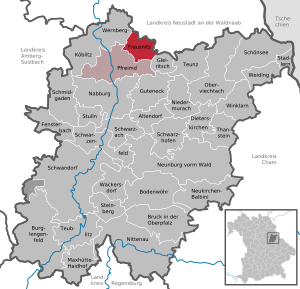
| Location of the community of Trausnitz in the district of Schwandorf | ||
Trausnitz is a municipality in the Upper Palatinate district of Schwandorf and a member of the Pfreimd administrative community .
geography
The municipality of Trausnitz is located on the lower reaches of the Pfreimd River in the Pfreimd Valley and is part of the Upper Palatinate Forest Nature Park .
Community structure
In addition to the main town, Trausnitz consists of the following ten districts:
|
history
Name Trausnitz
The Slavic sounding place name Trausnitz does not belong to the early Slavic settlement names such as Hohentreswitz , Köttlitz , Trefnitz or Gleiritsch . Initially it only referred to Trausnitz Castle and can be found in the files as "Traußnit, Trausniht, Trausnicht or Truwesnicht". The village was called Sächsenkirchen or Sessenkirchen until the end of the 14th century , the name of the castle was transferred to the village, and the name Trausnitz was created.
Aristocratic families on Trausnitz
Since the origin of the original settlement of Sächsenkirchen an der Pfreimd, a large number of aristocratic families can be found on Trausnitz. Among them were the Walturner zu Walthurn and Hostau, Weichnant Weigl (1305-1334), the Zenger, the Geiganter, Wiltinger, the Erlbecks (1515 to about 1585), the Freiherrn von Sporneck-Weißdorf (about 1570 to 1714), the barons von Quentel (1714 to 1763), Johann Balthasar von Hannakam (1763–1766) and Freiherr von Karg-Bebenburg until 1830. The house book of the Trausnitz community breaks down the owners of the castle.
Hofmark Trausnitz
The place was part of the Electorate of Bavaria and before 1800 formed a closed Hofmark of the barons of Hannakam. Actually, Baron von Karg had taken over the Hofmark in 1800 , but his legal claims were always controversial until the Hofmark was sold in 1830. In the course of the administrative reforms in Bavaria , today's community was created with the community edict of 1818 .
Incorporations
In 1946 the district of Oberpierlhof was incorporated into the previously independent municipality of Bernhof, which church does not belong to the Trausnitz parish, but continues to belong to the Tännesberg parish.
Söllitz was incorporated into the Trausnitz community on May 1, 1978 .
Population development
Between 1988 and 2018, the population decreased from 967 to 948 by 19 inhabitants or 2%.
religion
The Catholic parish of St. Joseph (Trausnitz) with its branch of St. Bartholomäus (Hohentreswitz) forms a parish community with the parish of St. Margaretha (Weihern). In Söllitz there is a branch church "Fourteen Helpers": patronage to "Peter and Paul" and the first weekend in July.
politics
Municipal council
In the municipal council election on March 15, 2020 , the following distribution of seats resulted.
| FWG | CSU |
|---|---|
| 6 seats | 3 seats |
mayor
Martin Schwandner (FWG) has been Mayor of Trausnitz since May 2014.
coat of arms
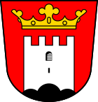
Blazon: "In red on a black three-mountain a silver pinnacle tower, floating above a golden crown of leaves". Coat of arms since 1968.
Culture and sights
Buildings
- Trausnitz Castle in the valley (not to be confused with Trausnitz Castle above Landshut)
- Saxon Tower
- Chapel of Reconciliation
- Catholic Church of St. Joseph
- Trausnitztalsperre
Sports
In the Pfreimdtal there is a reservoir that is used as a bathing lake.
Regular events
- Trausnitz Castle Festival , Wallercup in the reservoir
Others
The Reisach pumped storage plant , built in 1955, with two reservoirs (Rabenleite high storage facility) is located in the municipality . The power plant has a storage capacity of 135,000 kWh . An information center provides information on electricity generation in hydropower plants.
The singer Rolf Stahlhofen (including sons of Mannheim ) grew up in the Atzenhof district and attended elementary school in Trausnitz.
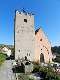
Church of St. Joseph (2012) ⊙
literature
- Johann Baptist Schütz: Chronicle of Trausnitz im Thal. Trausnitz 1890.
- Richard Hoffmann, Felix Mader: Art Monuments of the Kingdom of Bavaria, The Art Monuments of Upper Palatinate and Regensburg, District Office Nabburg. Munich 1910.
- Emma Mages: Historical Atlas of Bavaria, part of Old Bavaria. Issue 61, Oberviechtach, Munich 1996, ISBN 3-7696-9693-X
- Elisabeth Müller-Luckner: Historical Atlas of Bavaria, part of Old Bavaria. Issue 50, Nabburg, Munich 1981, ISBN 3-7696-9915-7
- Karl-Otto Ambronn: Historical Atlas of Bavaria, part of Old Bavaria. Series II, Issue 3, Landsassen and Landsassengüter of the Principality of the Upper Palatinate in the 16th century, Munich 1982, ISBN 3-7696-9932-7
Web links
- House book of the community of Trausnitz
- Aerial photos of the place
- Entry on the coat of arms of Trausnitz in the database of the House of Bavarian History
Individual evidence
- ↑ "Data 2" sheet, Statistical Report A1200C 202041 Population of the municipalities, districts and administrative districts 1st quarter 2020 (population based on the 2011 census) ( help ).
- ↑ Trausnitz community in the local database of the Bavarian State Library Online . Bavarian State Library, accessed on November 5, 2017.
- ^ Elisabeth Müller-Luckner: Historical Atlas of Bavaria, part of Altbayern, issue 50. Nabburg, p. 246
- ^ Johann Baptist Schütz: Chronicle of the royal Bavarian castle Trausnitz im Thal. P. 167
- ^ Helmut Reis: Castle Trausnitz im Thal in the house book of the community Trausnitz on GenWiki
- ^ Wilhelm Volkert (ed.): Handbook of Bavarian offices, communities and courts 1799–1980 . CH Beck, Munich 1983, ISBN 3-406-09669-7 , p. 530 .
- ^ Federal Statistical Office (ed.): Historical municipality directory for the Federal Republic of Germany. Name, border and key number changes in municipalities, counties and administrative districts from May 27, 1970 to December 31, 1982 . W. Kohlhammer GmbH, Stuttgart / Mainz 1983, ISBN 3-17-003263-1 , p. 668 .
- ↑ http://www.wahlen.bayern.de/kommunalwahlen/


