Oberpierlhof
|
Oberpierlhof
municipality Trausnitz
Coordinates: 49 ° 31 ′ 2 " N , 12 ° 17 ′ 34" E
|
||
|---|---|---|
| Height : | 500 m | |
| Postal code : | 92555 | |
| Area code : | 09655 | |
|
Location of Oberpierlhof in Bavaria |
||
|
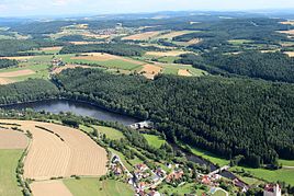
View over Trausnitz towards Oberpierlhof (left edge, 2013)
|
||
Oberpierlhof is a district of the Trausnitz community in the Schwandorf district .
geography
Oberpierlhof is located about 23 km west of the border with the Czech Republic in the central Upper Palatinate Forest , about 2.5 km east of the village of Trausnitz at an altitude of 500 meters. The Pfreimdtalstausee is located 700 m north of Oberpierlhof .
history
To the 11./12. The wave of clearing that began in the century with the Richt - und - ried -Orten ( Lampenricht , Trichenricht ) joined the 13/14. The expansion settlements of the - hofen and - hof places that were built in the 19th century . Bernhof , Bierlhof , Atzenhof and Oberpierlhof are examples of this.
Tax District and Parish Education
The Kingdom of Bavaria was divided into 15 districts in 1808. These districts were named after rivers based on the French model ( Naabkreis , Regenkreis , Unterdonaukreis , etc.). The districts were divided into district courts. The districts in turn should be divided into individual municipality areas. In 1828 the hamlets and solitary areas of Atzenhof, Bierlhof (= Unterbierlhof), Kaltenthal, Oberpierlhof, Ödmühl, Reisach, Schweizerbach and Trausnitz belonged to the Trausnitz community. The parish division did not last long. As early as 1830, the regional authorities were reorganized and reorganized. Boxmühle , Heilinghäusl , Zieglhäuser and Oberpierlhof came to the community of Bernhof . After the end of World War II , the American military government wanted to carry out a partial reorganization of the municipalities. She ordered the dissolution of smaller communities, including Bernhof with Oberpierlhof. In 1946 the Bernhof community was dissolved. Bernhof, Boxmühle, Heilinghäusl and Zieglhäuser were incorporated into the existing community of Gleiritsch , while Oberpierlhof became part of the Trausnitz community .
literature
- Alois Köppl: From the history of the community Gleiritsch. Gleiritsch community 1988, 2nd edition
- Ernst Schwarz: Language and Settlement in Northeast Bavaria . Nuremberg 1960
- Amberg State Archives, Rent Office No. 834
- Elisabeth Müller-Luckner, 'Historischer Atlas von Bayern, Teil Altbayern, Heft 50, Nabburg, Munich 1981, ISBN 3-7696-9915-7
- Emma Mages, Historical Atlas of Bavaria, Oberviechtach, Munich 1996, ISBN 3-7696-9693-X
Web links
Individual evidence
- ↑ Köppl, Alois, From the history of the community of Gleiritsch, Gleiritsch 1988, pp. 113–125.
- ^ Schwarz, Ernst, Language and Settlement in Northeast Bavaria, Nuremberg 1960, pp. 80 ff.
- ^ Emmering, Ernst, The Government of the Upper Palatinate, History of a Bavarian Central Authority, Contributions to the History and Regional Studies of the Upper Palatinate, Issue 20, Regensburg 1981, p. 12 ff.
- ^ Elisabeth Müller-Luckner, Historical Atlas of Bavaria, part of Old Bavaria, issue 50, Nabburg, p. 430
- ^ Mages, Emma, Historischer Atlas von Bayern, Oberviechtach, Munich 1996, p. 209
- ^ Wilhelm Volkert (ed.): Handbook of Bavarian offices, communities and courts 1799–1980 . CH Beck, Munich 1983, ISBN 3-406-09669-7 , p. 544 .


