Schweizerbach (Trausnitz)
|
Schweizerbach
municipality Trausnitz
Coordinates: 49 ° 30 ′ 33 ″ N , 12 ° 17 ′ 22 ″ E
|
||
|---|---|---|
| Height : | 460 m | |
| Postal code : | 92555 | |
| Area code : | 09655 | |
|
Location of Schweizerbach in Bavaria |
||
|
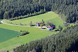
Schweizerbach (2017)
|
||
Schweizerbach is a district of the Trausnitz community in the Schwandorf district .
geography
The wasteland of Schweizerbach is located in the central Upper Palatinate Forest , around 2.5 km southeast of the village of Trausnitz at an altitude of 460 meters on the Schweizerbach stream, which rises south of Tännesberg and flows into the Gleiritsch as a right tributary at the Bornmühlschleife . Via the SAD 35 district road and a narrow path that branches off at the Bornmühlschleife, the Schweizererbach can be reached.
history
In the tax description of the Nabburg care office from 1764, Schweizerbach is described as follows: Not in Hoffuß , a wasenmeisterei (= wasenmeister, flayer or skinner who uses animal carcasses in an administrative district; Wasenplatz had to be created outside of the localities) with a small one Acker: “Although Joseph Raiser wasenmeister pawed the wasenmeistereye at the so-called Schweizererbachl and the following fields on such a Hofmarchs Grundt, which was already under the knight's tax; So such is still with the aydischen estimate ad 100 fl. ".
Tax District and Parish Education
The Kingdom of Bavaria was divided into 15 districts in 1808. These districts were named after rivers based on the French model ( Naabkreis , Regenkreis , Unterdonaukreis , etc.). The districts were divided into district courts. The districts in turn should be divided into individual municipality areas. In 1811 the district court of Nabburg was divided into 58 tax districts. One of them was Fuchsendorf, "consisting of the villages Fuchsendorf, Atzenhof, the lower Bühlhof (= Bierlhof), the hamlet Schweizerbach, the wasteland Bornmühle". In 1828 the hamlets and solitary areas of Atzenhof , Bierlhof (= Unterbierlhof), Kaltenthal , Oberpierlhof , Ödmühl, Reisach, Schweizerbach and Trausnitz belonged to the Trausnitz community.
literature
- Elisabeth Müller-Luckner, Historical Atlas of Bavaria, part of Old Bavaria, issue 50, Nabburg, Munich 1981, ISBN 3-7696-9915-7
Web links
Individual evidence
- ^ Elisabeth Müller-Luckner, Historical Atlas of Bavaria, part of Altbayern, issue 50, Nabburg, p. 363.
- ^ Emmering, Ernst, The Government of the Upper Palatinate, History of a Bavarian Central Authority, Contributions to the History and Regional Studies of the Upper Palatinate, Issue 20, Regensburg 1981, p. 12 ff.
- ^ Elisabeth Müller-Luckner, Historical Atlas of Bavaria, part of Old Bavaria, issue 50, Nabburg, p. 398.
- ^ Elisabeth Müller-Luckner, Historical Atlas of Bavaria, part of Old Bavaria, issue 50, Nabburg, p. 430.


