
Tännesberg
| coat of arms | Germany map | |
|---|---|---|

|
Coordinates: 49 ° 32 ' N , 12 ° 20' E |
|
| Basic data | ||
| State : | Bavaria | |
| Administrative region : | Upper Palatinate | |
| County : | Neustadt an der Waldnaab | |
| Management Community : | Tännesberg | |
| Height : | 585 m above sea level NHN | |
| Area : | 46.56 km 2 | |
| Residents: | 1483 (Dec. 31, 2019) | |
| Population density : | 32 inhabitants per km 2 | |
| Postal code : | 92723 | |
| Area code : | 09655 | |
| License plate : | NEW, ESB , VOH | |
| Community key : | 09 3 74 159 | |
| Market structure: | 15 districts | |
Market administration address : |
Pfreimder Strasse 1 92723 Tännesberg |
|
| Website : | ||
| Mayor : | Ludwig Gürtler (Free Voters Group) | |
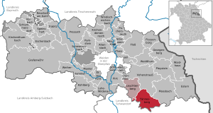
| Location of the Tännesberg market in the Neustadt an der Waldnaab district | ||
  |
||


Tännesberg is a market in the south of the Upper Palatinate district of Neustadt an der Waldnaab and the seat of the Tännesberg administrative community .
The market is a state-approved resort .
geography
Geographical location
Tännesberg is located in the middle Upper Palatinate Forest . The entire municipality belongs to the Northern Upper Palatinate Forest Nature Park . The highest point is the Schwangbühl (748 m) in the eastern forest area of Tännesberger Wald . This is where the Mühlbach rises and flows past Pilchau , Neumühle and Schnegelmühle before it flows into the Gleiritsch at Lampenricht .
Neighboring communities
Tännesberg borders in the north on Leuchtenberg and Vohenstrauss , in the east on Moosbach , in the south on Teunz and Gleiritsch (both district Schwandorf ) and in the west on Trausnitz (also district Schwandorf).
Community structure
The municipality of Tännesberg has 15 parts of the municipality:
|
There are the following markings :
|
|
history
Until the 19th century
Tännesberg was first mentioned in 1150 in the tradition code of the Reichenbach monastery . At that time Abbot Erchinger transferred the Weidental and Willhof estates to Reginger de Tegenisperc for administration. In this context, an Otto de Tegeninsperc appeared as a witness at the transfer.
Reginger and Otto were vassals of the powerful Diepoldingen, the Margraves of Nabburg, who were enfeoffed with the Cham and Nabburg brands towards the end of the 11th century. At that time there was a castle in Tännesberg, which the margraves called their property (Allod) and employed followers or servants there for administration.
After the Diepoldinger dynasty died out, the Tännesberg castle and rule came to the Counts of Sulzbach, who were inherited by the Counts of Ortenburg in 1188 . They set up their own ministerials in Tännesberg. They came from the Paulsdorfer family , who can be identified with Henricus de Teininsberg and in 1237 with Friedrich von Tännesberg. In 1276 at the latest, the Paulsdorfer named themselves after their new headquarters in Tännesberg ; In 1280 the rule passed into their possession.
In 1400 the Paulsdorfer sold their possessions in Tännesberg to Ruprecht III. from the Palatinate and Tännesberg became an (Upper) Palatinate maintenance office of the Wittelsbachers in the Amberg rent office . Heinrich Frickenhofer seems to have been the first keeper for the "Denelsperc".
When the Palatinate Lands were divided, Tännesberg came to the Neumarkt-Neunburg Palatinate and the new lord, Count Palatine Johann, made the place a market in 1412. In 1570, Count Palatine Ludwig granted a grant of 210 guilders to build a first wall. As part of the Reformed line of the Wittelsbacher, Tännesberg, which had had a Catholic pastoral office since 1326, became Protestant.
In the Thirty Years' War the Upper Palatinate and thus also Tännesberg came to the Bavarian Wittelsbachers and Elector Maximilian I of Bavaria reintroduced the Catholic faith in Tännesberg in 1625.
The Thirty Years War brought various catastrophes. The plague broke out in Tännesberg as early as 1634 . At that time there were only five couples living in the market. In 1639 40 houses burned down and the market walls had collapsed for lack of building money. Three years later, Octavio Piccolomini's troops marched through the village and the Tännesbergers had to take in soldiers. Another fire in the same year caused the church tower to collapse and damaged the town hall and several houses.
In the course of the administrative reforms in Bavaria , today's municipality was created with the municipal edict of 1818 .
In the night of August 4, 1839, the place burned down almost completely, which is why it was decided to realign the land.
Incorporations
On January 1, 1972, the previously independent municipality of Kleinschwand was incorporated. Großenschwand was added on July 1, 1972. Territory parts of the dissolved community Döllnitz followed on July 1, 1976. The place Pilchau of the dissolved community Zeinried was incorporated on May 1, 1978.
Population development
Population development in the municipality of Tännesberg taking into account the incorporations:
| year | 1840 | 1871 | 1900 | 1925 | 1939 | 1950 | 1961 | 1970 | 1987 | 1991 | 1995 | 2005 | 2010 | 2015 |
| Residents | 1777 | 1807 | 1692 | 1659 | 1676 | 1939 | 1586 | 1695 | 1579 | 1663 | 1721 | 1565 | 1506 | 1531 |
Between 1988 and 2018 the population decreased from 1,552 to 1,487 by 65 inhabitants or by 4.2%.
politics
Municipal council
Of the twelve members of the municipal council, since the local elections on March 16, 2014, the CSU has occupied seven seats (57.12% of the votes) and the Free Voters five seats (42.88% of the votes).
mayor
The honorary first mayor is Ludwig Gürtler (Free Voters Group). He has been in office since May 1, 2020. He won the 2020 mayoral election with 55.2% of the vote against the incumbent Max Völkl.
coat of arms
Blazon: In silver on a ground formed by small green hills, two trees, between two red flowers on leafy green stems; the diamond shield floating above it.
The coat of arms has been known since the 15th century.
Town twinning
Kirchlengern , Herford district , North Rhine-Westphalia (since 1982)
Culture and sights
Buildings

- Pilgrimage Church of St. Jodok . Built in 1689, it has been the destination of the Sankt-Jodok-Ritt , a horse pilgrimage every year since 1796, on the 4th Sunday of July . Since 1690 there has been the “Vienna Plague Cross” in the church.
- Parish Church of St. Michael . The originally medieval church was enlarged in the 18th century in baroque style and rebuilt after a fire in 1828. It contains figures of saints from the 18th century and ceiling paintings from the late 19th century.
- Burgstall Tännesberg on the Schlossberg
- Jansen an der Pfreimd power plant group with Tanzmühle pumped storage plant , 25.2 MW, Reisach-Rabenleite pumped storage plant, 98.3 MW and Trausnitz compensation plant (Bavaria), together 135 MW, 1951–1961
Architectural monuments
Nature trails
- Geological nature trail
- Fruit trail
Conservation projects
Various nature conservation projects were carried out in the Tännesberg market area. Since 2009 the community has been a "Bavarian Model Community Biodiversity ". Particular emphasis is placed on promoting the biodiversity of animals and plants. Old cultivars such as potatoes , emmer , einkorn and spelled are grown. With the reintroduction of the old domestic breed of cattle , ecologically valuable areas can be preserved.
Natural monuments
- Schlossberg (692 m above sea level), highest elevation in Tännesberg, worth seeing: Stations of the Cross and chapel on the Schlossberg
Regular events
- The Sankt Jodokritt in Tännesberg, a horse pilgrimage , always takes place on the fourth weekend in July
- Oven festival, always takes place on the fourth Sunday in August
traffic
The federal road 22 crosses the municipality in a north-south direction.
Sons and Daughters of the Market
- Johann Baptist von Anzer (1851–1903), Roman Catholic bishop in China
- Carl Burger (1875–1950), sculptor
- Simon Wittmann (* 1947), politician, 1996–2014 District Administrator of the Neustadt an der Waldnaab district

Parish Church of St. Michael
Pilchau (2012)

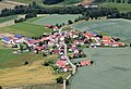
Großenschwand (2015)

Elevated storage near Großenschwand (2015)

Kleinschwand (2009)

Fischerhammer, Kainzmühle (2009)


literature
- Tännesberg Catholic Parish: Parish Church of St. Michael, Pilgrimage Church of St. Jodok. 1984 (brochure, 16 pages).
- Rich. Hoffmann, Georg Hager: The art monuments of the Kingdom of Bavaria, Upper Palatinate and Regensburg VIII. District Office Vohenstrauss, Munich 1907.
- Georg Hager: The art monuments of the Kingdom of Bavaria, Upper Palatinate and Regensburg VII. District Office Oberviechtach, Munich 1906.
- Dieter Bernd: Vohenstrauss . In: Historical Atlas of Bavaria , part of Old Bavaria . Series I, issue 39. Komm. Für Bayerische Landesgeschichte, Munich 1977, ISBN 3-7696-9900-9 ( digitized version ).
- Karl-Otto Ambronn: Historical Atlas of Bavaria, part of Old Bavaria. Series II, Issue 3, Landsassen and Landsassengüter of the Principality of the Upper Palatinate in the 16th century. Munich 1982, ISBN 3-7696-9932-7 .
- Alois Köppl: Tännesberg. Series: Experience Upper Palatinate, Gleiritsch 2012, ISBN 978-3-00-039105-7 .
- C. Rückerl (2013): Tännesberg - a biodiversity community as a model for Bavaria. - ANLiegen Natur 35 (2), pp. 84–85, Laufen. PDF 0.2 MB .
Web links
- Aerial views of the market
- Entry on the coat of arms of Tännesberg in the database of the House of Bavarian History
Individual evidence
- ↑ "Data 2" sheet, Statistical Report A1200C 202041 Population of the municipalities, districts and administrative districts 1st quarter 2020 (population based on the 2011 census) ( help ).
- ↑ a b Mayor / Lord Mayor in municipalities belonging to the district (as of May 1st, 2020). (xlsx) Bavarian State Office for Statistics, accessed on June 20, 2020 .
- ^ Community Tännesberg in the local database of the Bayerische Landesbibliothek Online . Bavarian State Library, accessed on November 19, 2017.
- ^ Wilhelm Volkert (ed.): Handbook of Bavarian offices, communities and courts 1799–1980 . CH Beck, Munich 1983, ISBN 3-406-09669-7 , p. 587 .
- ^ Federal Statistical Office (ed.): Historical municipality directory for the Federal Republic of Germany. Name, border and key number changes in municipalities, counties and administrative districts from May 27, 1970 to December 31, 1982 . W. Kohlhammer, Stuttgart / Mainz 1983, ISBN 3-17-003263-1 , p. 652 f .
- ^ Database statistical data for Bavaria
- ↑ Alois Köppl: Tännesberg , Gleiritsch 2012, p. 4

Altenstadt an der Waldnaab |
Bechtsrieth |
Eschenbach in the Upper Palatinate |
Eslarn |
Etzenricht |
Raft |
Flossenbürg |
Georgenberg |
Grafenwohr |
Irchenrieth |
Kirchendemenreuth |
Kirchenthumbach |
Kohlberg |
Leuchtenberg |
Luhe-Wildenau |
Coat |
Moosbach |
Neustadt am Kulm |
Neustadt an der Waldnaab |
Park stone |
Pirk |
Pleystein |
Pressath |
Püchersreuth |
Umbrella seat |
Schlammersdorf |
Schwarzenbach |
Super tough |
Störnstein |
Tännesberg |
Theisseil |
Trabitz |
Vohenstrauss |
Vorbach |
Waidhaus |
Waldthurn |
Weiherhammer |
Windischeschenbach
Unregulated areas: Heinersreuther Forst | Manteler Forest | Speiny forest
Fishing hammer | Großenschwand | Kainzmühle | Karlhof | Kaufnitz | Kleinschwand | Neumühle | Schnegelmühle | Tännesberg | Dance mill | Voitsberg | Weinrieth | Woppenrieth