
Theisseil
| coat of arms | Germany map | |
|---|---|---|

|
Coordinates: 49 ° 41 ' N , 12 ° 14' E |
|
| Basic data | ||
| State : | Bavaria | |
| Administrative region : | Upper Palatinate | |
| County : | Neustadt an der Waldnaab | |
| Management Community : | Neustadt an der Waldnaab | |
| Height : | 557 m above sea level NHN | |
| Area : | 21.4 km 2 | |
| Residents: | 1188 (Dec. 31, 2019) | |
| Population density : | 56 inhabitants per km 2 | |
| Postal code : | 92637 | |
| Primaries : | 09602, 0961, 09657 | |
| License plate : | NEW, ESB , VOH | |
| Community key : | 09 3 74 160 | |
| Community structure: | 14 districts | |
| Association administration address: | Naabstr. 5 92660 Neustadt ad Waldnaab |
|
| Website : | ||
| Mayoress : | Marianne Rauh ( CSU ) | |
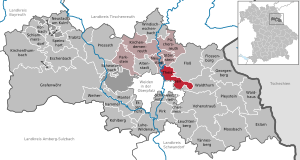
| Location of the community of Theisseil in the district of Neustadt an der Waldnaab | ||
  |
||

Theisseil is a municipality in the Upper Palatinate district of Neustadt an der Waldnaab and a member of the Neustadt an der Waldnaab administrative community .
geography
Geographical location
The place is about five kilometers northeast of the city of Weiden in the Oberpfalz-Nord region .
Community structure
The community has 14 districts:
|
There are the districts Edeldorf, Letzau, Roschau and Wilchenreuth.
history
Until the founding of the forerunner churches
Theisseil belonged to the Duchy of Neuburg-Sulzbach and its court Floß, which came to Bavaria in 1777 . Roschau, which is part of the municipality today, was part of the Fürsteten Grafschaft Störnstein (Sternstein) and only fell to Bavaria in 1806. In 1818, with the municipal edict in Bavaria, the precursors of today's political municipality, the municipalities of Edeldorf, Letzau and Roschau, emerged.
Incorporations
The municipality of Theisseil was newly formed in the course of the municipal reform on July 1, 1972 from the previously independent municipalities of Edeldorf, Letzau and Roschau. The place Theisseil was previously a district of the community Edeldorf.
Population development
- 1961: 634 inhabitants
- 1970: 646 inhabitants
- 1987: 985 inhabitants
- 1991: 1093 inhabitants
- 1995: 1193 inhabitants
- 2000: 1256 inhabitants
- 2005: 1249 inhabitants
- 2010: 1223 inhabitants
- 2015: 1169 inhabitants
Between 1988 and 2018 the municipality grew from 996 to 1179 by 183 inhabitants or 18.4% of the population.
politics
Mayoress
Marianne Rauh (CSU) has been mayor since 2008. Her predecessor was Herbert Hösl (CSU).
Municipal council
The local elections on March 16, 2014 resulted in the following distribution of seats:
coat of arms
Blazon: In blue over two horizontal, mutilated silver branches, next to each other two six-pointed silver stars
The coat of arms has been used since 1979.
Architectural monuments
Economy and Infrastructure
Economy including agriculture and forestry
The municipal tax receipts in 1999 amounted to the equivalent of 329 T €, of which the equivalent of 31 T € (net) was trade tax income.
In 1998, according to official statistics, there were no employees in the manufacturing sector and no employees in the trade and transport sector at the place of work. In other economic sectors, 23 people were employed at the place of work subject to social security contributions. There were a total of 255 employees at the place of residence subject to social security contributions. There were no companies in the manufacturing or construction industries. In 1999 there were 54 farms with an agriculturally used area of 1359 ha, of which 850 ha were arable land and 508 ha were permanent green space.
Buildings
- Telecommunications tower Weiden on the Geissleite
- Evangelical Church of St. Ulrich Wilchenreuth : Romanesque gem from the 12th century with a rare depiction of Christ Pantocrator in the east apse
- Catholic Church St. Ulrich Wilchenreuth : Church building from the early 20th century
Personalities
- Leopold Hofmann (1896–1963), politician born in Theisseil, member of the Bavarian State Parliament
Individual evidence
- ↑ "Data 2" sheet, Statistical Report A1200C 202041 Population of the municipalities, districts and administrative districts 1st quarter 2020 (population based on the 2011 census) ( help ).
- ↑ http://www.bayerische-landesbibliothek-online.de/orte/ortssuche_action.html ? Anzeige=voll&modus=automat&tempus=+20111107/181723&attr=OBJ&val= 994
- ^ Wilhelm Volkert (ed.): Handbook of Bavarian offices, communities and courts 1799–1980 . CH Beck, Munich 1983, ISBN 3-406-09669-7 , p. 538 .
- ↑ http://www.wahlen.bayern.de/biz/kowa_g2008.php?g=h&schluessel=374&suchbegriff=3
Web links
- theisseil.de - Official website
- Entry on Theisseil's coat of arms in the database of the House of Bavarian History
Aich | Edeldorf | Fichtlmühle | Görnitz | Hammerharlesberg | Harlesberg | Letzau | Upper Hell | Remmelberg | Roshau | Schammesrieth | Theisseil (Kernort) | Wiedenhof | Wilchenreuth

Altenstadt an der Waldnaab |
Bechtsrieth |
Eschenbach in the Upper Palatinate |
Eslarn |
Etzenricht |
Raft |
Flossenbürg |
Georgenberg |
Grafenwohr |
Irchenrieth |
Kirchendemenreuth |
Kirchenthumbach |
Kohlberg |
Leuchtenberg |
Luhe-Wildenau |
Coat |
Moosbach |
Neustadt am Kulm |
Neustadt an der Waldnaab |
Park stone |
Pirk |
Pleystein |
Pressath |
Püchersreuth |
Umbrella seat |
Schlammersdorf |
Schwarzenbach |
Super tough |
Störnstein |
Tännesberg |
Theisseil |
Trabitz |
Vohenstrauss |
Vorbach |
Waidhaus |
Waldthurn |
Weiherhammer |
Windischeschenbach
Unregulated areas: Heinersreuther Forst | Manteler Forest | Speiny forest