
Wilchenreuth
|
Wilchenreuth
Theisseil parish
Coordinates: 49 ° 42 ′ 23 ″ N , 12 ° 13 ′ 10 ″ E
|
||
|---|---|---|
| Height : | 498 m above sea level NHN | |
| Residents : | 85 (May 9, 2011) | |
| Postal code : | 92637 | |
| Area code : | 09602 | |
Location of Wilchenreuth in Bavaria |
||

Wilchenreuth is a district of the municipality Theisseil in the district of Neustadt an der Waldnaab in Bavaria .
The place is north of the core town Theisseil. The NEW 27 runs to the west, the Elzenbach, a left tributary of the Girnitz , flows to the east .
Population development in Wilchenreuth from 1817
| year | Residents | building |
|---|---|---|
| 1817 | 117 | 22nd |
| 1861 | 165 | k. A. |
| 1871 | 152 | 58 |
| 1885 | 159 | 23 |
| 1900 | 123 | 21st |
| 1925 | 148 | 25th |
| year | Residents | building |
|---|---|---|
| 1950 | 166 | 24 |
| 1961 | 96 | 25th |
| 1970 | 92 | k. A. |
| 1987 | 91 | 29 |
| 2011 | 85 | k. A. |
Attractions
In the list of monuments in Theisseil , four monuments are listed for Wilchenreuth , including
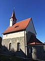
St. Ulrich, Protestant (2017)

St. Ulrich, Catholic (2017)


Individual evidence
- ↑ a b ZENSUS2011 - Census Atlas. In: atlas.zensus2011.de. Retrieved September 15, 2019 .
- ^ I. Official localities / place directories. In: bayerische-landesbibliothek-online.de. Retrieved September 15, 2019 .
- ↑ a b Historical Atlas of Bavaria: Altbayern Series I, Issue 47: Neustadt an der Waldnaab, Weiden, pp. 51, 97, 110, 237, 359, 364, 397, 409, 428
- ↑ Kgl. Statistical Bureau (ed.): Complete list of localities of the Kingdom of Bavaria. According to districts, administrative districts, court districts and municipalities, including parish, school and post office affiliation ... with an alphabetical general register containing the population according to the results of the census of December 1, 1875 . Adolf Ackermann, Munich 1877, 2nd section (population figures from 1871, cattle figures from 1873), Sp. 909 , urn : nbn: de: bvb: 12-bsb00052489-4 ( digital copy ).
- ↑ K. Bayer. Statistical Bureau (Ed.): Localities directory of the Kingdom of Bavaria. According to government districts, administrative districts, ... then with an alphabetical register of locations, including the property and the responsible administrative district for each location. LIV. Issue of the contributions to the statistics of the Kingdom of Bavaria. Munich 1888, Section III, Sp. 857 ( digitized version ).
- ↑ K. Bayer. Statistical Bureau (Ed.): Directory of localities of the Kingdom of Bavaria, with alphabetical register of places . LXV. Issue of the contributions to the statistics of the Kingdom of Bavaria. Munich 1904, Section II, Sp. 889 ( digitized version ).
- ↑ Bavarian State Statistical Office (ed.): Localities directory for the Free State of Bavaria according to the census of June 16, 1925 and the territorial status of January 1, 1928 . Issue 109 of the articles on Bavaria's statistics. Munich 1928, Section II, Sp. 898 ( digitized version ).
- ↑ Bavarian State Statistical Office (ed.): Official place directory for Bavaria - edited on the basis of the census of September 13, 1950 . Issue 169 of the articles on Bavaria's statistics. Munich 1952, DNB 453660975 , Section II, Sp. 760 ( digitized version ).
- ↑ Bavarian State Statistical Office (ed.): Official city directory for Bavaria, territorial status on October 1, 1964 with statistical information from the 1961 census . Issue 260 of the articles on Bavaria's statistics. Munich 1964, DNB 453660959 , Section II, Sp. 562 ( digitized version ).
- ^ Bavarian State Statistical Office (ed.): Official place directory for Bavaria . Issue 335 of the articles on Bavaria's statistics. Munich 1973, DNB 740801384 , p. 132 ( digitized version ).
- ↑ Bavarian State Office for Statistics and Data Processing (Ed.): Official local directory for Bavaria, territorial status: May 25, 1987 . Issue 450 of the articles on Bavaria's statistics. Munich November 1991, DNB 94240937X , p. 265 ( digitized version ).
Web links
Commons : Wilchenreuth - Collection of images, videos and audio files
- Wilchenreuth district on the website of the community of Theisseil, accessed on November 4, 2019

Districts of Theisseil
Aich | Edeldorf | Fichtlmühle | Görnitz | Hammerharlesberg | Harlesberg | Letzau | Upper Hell | Remmelberg | Roshau | Schammesrieth | Theisseil (Kernort) | Wiedenhof | Wilchenreuth