
Pirk
| coat of arms | Germany map | |
|---|---|---|

|
Coordinates: 49 ° 38 ' N , 12 ° 10' E |
|
| Basic data | ||
| State : | Bavaria | |
| Administrative region : | Upper Palatinate | |
| County : | Neustadt an der Waldnaab | |
| Management Community : | Umbrella seat | |
| Height : | 397 m above sea level NHN | |
| Area : | 26.17 km 2 | |
| Residents: | 1878 (Dec. 31, 2019) | |
| Population density : | 72 inhabitants per km 2 | |
| Postal code : | 92712 | |
| Area code : | 0961 | |
| License plate : | NEW, ESB , VOH | |
| Community key : | 09 3 74 146 | |
| Address of the municipal administration: |
Main street 12 92718 umbrella seat |
|
| Website : | ||
| Mayor : | Dietmar Schaller (Free Voters) | |
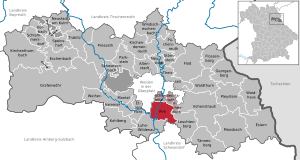
| Location of the municipality of Pirk in the district of Neustadt an der Waldnaab | ||
  |
||


Pirk is a municipality in the Upper Palatinate district of Neustadt an der Waldnaab and a member of the administrative association Schirmitz .
geography
Geographical location
Pirk is located in the Upper Palatinate North planning region .
Community structure
The municipality of Pirk has eleven districts:
There are the following districts : Engleshof, Enzenrieth, Pirk, Au, Gleitsmühle, Hochdorf, Matzlesberg, Pirkerziegelhütte, Pirkmühle, Pischeldorf, Zeissau.
history
Until the church is planted
The place was first mentioned in a document in 1092. Since 1349/52 Pirk belonged to the Landgraviate of Leuchtenberg (or later to the Leuchtenberg court) and from 1646 was part of the Electorate of Bavaria . The barons of Riesenfeld owned an open Hofmark here , the seat of which was Pirk. In the course of the administrative reforms in Bavaria , today's municipality was created with the municipal edict of 1818 .
Incorporations
On January 1, 1972, the previously independent municipality of Enzenrieth was incorporated. On May 1, 1978, parts of the dissolved Engleshof parish were added.
Population development
- 1961: 1233 inhabitants
- 1970: 1602 inhabitants
- 1987: 1629 inhabitants
- 1991: 1648 inhabitants
- 1995: 1759 inhabitants
- 2000: 1865 inhabitants
- 2005: 1937 inhabitants
- 2010: 1794 inhabitants
- 2015: 1819 inhabitants
Between 1988 and 2018 the municipality grew from 1624 to 1840 by 216 inhabitants or 13.3% of the population.
politics
mayor
Mayor is Michael Bauer (Free Voters). In 2002 he succeeded Georg Stahl (CSU), who held the office from 1972 to 2002.
coat of arms
Blazon: A green birch with roots in gold, the trunk of which has a silver shield with a blue bar on top.
The coat of arms has been used since 1973.
Culture and sights
- Chapel Maria, the knot loosener
- Enzenrieth Castle , castle building from the 17th century
Architectural monuments
Economy and Infrastructure
Economy including agriculture and forestry
Important local businesses are the industrial company Constantia Hueck Folien and the Pirker Brauhaus (the latter has been sold to the Würth Brewery, Windischeschenbach since 06.2013).
In 1998, according to official statistics, there were 754 in the manufacturing industry and in the trade and transport sector no employees subject to social insurance contributions at the place of work. There were a total of 650 employees at the place of residence subject to social security contributions. There was one company in the manufacturing sector, none in the main construction sector. In addition, in 1999 there were 51 farms with an agricultural area of 1,406 hectares, of which 944 hectares were arable land and 462 were permanent green areas.
education
The following institutions exist (as of: 1999):
- 50 kindergarten places with 62 children
- an elementary school with twelve teachers and 224 students
- a secondary school (in the same building as the primary school)

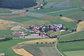
Pirk (2012)

Matzlesberg (2012)
Engleshof (2012)

Pischeldorf (2012)

Hochdorf, Enzenrieth (2012)


Individual evidence
- ↑ "Data 2" sheet, Statistical Report A1200C 202041 Population of the municipalities, districts and administrative districts 1st quarter 2020 (population based on the 2011 census) ( help ).
- ↑ http://www.bayerische-landesbibliothek-online.de/orte/ortssuche_action.html ? Anzeige=voll&modus=automat&tempus=+20111107/164848&attr=OBJ&val= 983
- ^ Wilhelm Volkert (ed.): Handbook of Bavarian offices, communities and courts 1799–1980 . CH Beck, Munich 1983, ISBN 3-406-09669-7 , p. 538 .
- ^ Federal Statistical Office (ed.): Historical municipality directory for the Federal Republic of Germany. Name, border and key number changes in municipalities, counties and administrative districts from May 27, 1970 to December 31, 1982 . W. Kohlhammer GmbH, Stuttgart / Mainz 1983, ISBN 3-17-003263-1 , p. 653 .
- ↑ Untying the knot - blessing of the chapel on the edge of the forest ( Upper Palatinate Network of May 14, 2014)
Web links
- Entry on the coat of arms of Pirk in the database of the House of Bavarian History

Altenstadt an der Waldnaab |
Bechtsrieth |
Eschenbach in the Upper Palatinate |
Eslarn |
Etzenricht |
Raft |
Flossenbürg |
Georgenberg |
Grafenwohr |
Irchenrieth |
Kirchendemenreuth |
Kirchenthumbach |
Kohlberg |
Leuchtenberg |
Luhe-Wildenau |
Coat |
Moosbach |
Neustadt am Kulm |
Neustadt an der Waldnaab |
Park stone |
Pirk |
Pleystein |
Pressath |
Püchersreuth |
Umbrella seat |
Schlammersdorf |
Schwarzenbach |
Super tough |
Störnstein |
Tännesberg |
Theisseil |
Trabitz |
Vohenstrauss |
Vorbach |
Waidhaus |
Waldthurn |
Weiherhammer |
Windischeschenbach
Unregulated areas: Heinersreuther Forst | Manteler Forest | Speiny forest