
Administrative community Schirmitz
| coat of arms | Germany map | |
|---|---|---|
 Help on coat of arms |
Coordinates: 49 ° 39 ' N , 12 ° 10' E |
|
| Basic data | ||
| State : | Bavaria | |
| Administrative region : | Upper Palatinate | |
| County : | Neustadt an der Waldnaab | |
| Area : | 41.19 km 2 | |
| Residents: | 6466 (Dec. 31, 2019) | |
| Population density : | 157 inhabitants per km 2 | |
| License plate : | NEW, ESB , VOH | |
| Association key : | 09 3 74 5329 | |
| Association structure: | 4 municipalities | |
| Association administration address : |
Hauptstrasse 12 92718 Schirmitz |
|
| Website : | ||
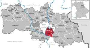
| Location of the administrative community Schirmitz in the district of Neustadt an der Waldnaab | ||
  |
||

The administrative community Schirmitz is located in the Upper Palatinate district of Neustadt an der Waldnaab and is formed by the following communities:
- Irchenrieth , 1519 inhabitants, 5.27 km²
- Pirk , 1878 inhabitants, 26.17 km²
- Schirmitz , 1980 inhabitants, 4.97 km²
- Bechtsrieth , 1089 inhabitants, 4.78 km²
The administrative community is based in Schirmitz.
In addition to the three original member communities, the Bechtsrieth community joined the community on January 1, 1994. It had been part of the Irchenrieth community since 1978 and regained independence.
Individual evidence
- ↑ "Data 2" sheet, Statistical Report A1200C 202041 Population of the municipalities, districts and administrative districts 1st quarter 2020 (population based on the 2011 census) ( help ).
- ↑ Art. 11 of the fourth law to change the structure of municipalities and administrative communities of November 9, 1993 ( GVBl p. 830)
Administrative communities in the Neustadt an der Waldnaab district
Eschenbach idOPf. | Kirchenthumbach | Neustadt adWaldnaab | Pleystein | Pressath | Umbrella seat | Tännesberg | Weiherhammer
Resolved: raft