
Umbrella seat
| coat of arms | Germany map | |
|---|---|---|

|
Coordinates: 49 ° 39 ' N , 12 ° 10' E |
|
| Basic data | ||
| State : | Bavaria | |
| Administrative region : | Upper Palatinate | |
| County : | Neustadt an der Waldnaab | |
| Management Community : | Umbrella seat | |
| Height : | 393 m above sea level NHN | |
| Area : | 4.97 km 2 | |
| Residents: | 1980 (Dec. 31, 2019) | |
| Population density : | 399 inhabitants per km 2 | |
| Postal code : | 92718 | |
| Area code : | 0961 | |
| License plate : | NEW, ESB , VOH | |
| Community key : | 09 3 74 154 | |
| Community structure: | 1 district | |
| Address of the municipal administration: |
Main street 12 92718 umbrella seat |
|
| Website : | ||
| Mayor : | Ernst Lenk jun. ( CSU ) | |
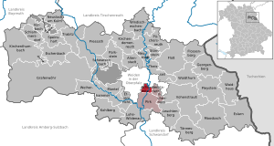
| Location of the community of Schirmitz in the district of Neustadt an der Waldnaab | ||
  |
||


Schirmitz is a municipality in the Upper Palatinate district of Neustadt an der Waldnaab and the seat of the administrative community Schirmitz , to which three other municipalities ( Pirk , Bechtsrieth and Irchenrieth ) belong.
geography
Geographical location
Schirmitz is located in the Upper Palatinate North planning region . The community is located in the immediate vicinity of the Oberzentrum Weiden on the eastern edge of the so-called Weiden basin , a flat plain that extends around the city of Weiden. To the east of Schirmitz are the first foothills of the Upper Palatinate Forest , which make the area hilly and scenic. From the elevation in the south-eastern municipality on the road to Bechtsrieth you have a view over the entire Weiden basin with the basalt cones of Parkstein and Rauhem Kulm . Schirmitz is located on the Waldnaab , which crosses the Upper Palatinate from north to south and is later referred to as Naab .
Community structure
There is only the district and the area of Schirmitz.
history
Until the church is planted
Schirmitz was first mentioned in a document in 1223 when "Marcward von Schirnwitz" appeared as a witness in a legal dispute between Diepold von Leuchtenberg and Heinrich von Ortenburg-Murach . The place was later part of the Electorate of Bavaria and formed a closed Hofmark of the barons of Hannakam, whose seat was Schirmitz. In the course of the administrative reforms in Bavaria , today's municipality was created with the municipal edict of 1818 .
Population development
The table shows the population development in Schrimitz from 1970.
| 1970 | 1987 | 1991 | 1995 | 2000 | 2005 | 2010 | 2015 |
|---|---|---|---|---|---|---|---|
| 1721 | 1624 | 1769 | 1974 | 2139 | 2123 | 2057 | 1991 |
Between 1988 and 2018 the municipality grew from 1,643 to 1,969 by 326 inhabitants or 19.8%.
Sports
- SpVgg Schirmitz 1921 e. V.
- Soccer
- tennis
- basketball
- gymnastics
- Bowling
- Cycling
- Health sport
- Rifle club "Hubertus" e. V.
coat of arms
Blazon: “Split; in front under a silver shield head, inside a blue bar, in red a left-facing golden lion's body, behind under a blue shield head in silver a red dragon's body. "
The municipality has had the coat of arms since 1980.
Architectural monuments
economy
The Schirmitz economy is primarily structured on a small scale. Small and medium-sized companies, especially in the skilled trades, shape the corporate landscape. There are several wood processing companies, gardening and landscaping, hairdressers, butchers and restaurants in the community. A now only very small percentage of the population work in agriculture and forestry. There are no larger industrial companies.
In the south of Schirmitz there is a larger E.ON 110 kV substation .
Parish and Church

In addition to the parish of Schirmitz, the parish of Schirmitz also includes the places Bechtsrieth and Trebsau. In the area of Schirmitz there are two churches: the Jakobskirche, popularly known as the "Old Church", and the parish church of Maria Königin, known as the "New Church". Until 1958, the Jakobskirche was the only church in Schirmitz and, as a parish church, the center of religious life. It stands together with the cemetery, rectory, old kindergarten and today's Jakobsklause at the southern exit of the village. St. Jakob is a choir tower church that was built around the year 1300. The tower erected directly above the chancel, to which a single-nave nave adjoins, is typical. In 1957 the foundation stone for the new parish church Maria Königin was laid. The symbolic foundation stone (lapis primarius) can be seen in the sacristy area of the church. At the end of 1958, mass celebrations could already be held in the not yet completely finished church. The Jakobskirche is mainly used for weddings, funerals and occasionally for church services.
Individual evidence
- ↑ "Data 2" sheet, Statistical Report A1200C 202041 Population of the municipalities, districts and administrative districts 1st quarter 2020 (population based on the 2011 census) ( help ).
- ↑ bayerische-landesbibliothek-online.de
Web links
- Community website
- Entry on the coat of arms of Schirmitz in the database of the House of Bavarian History
literature
- AW Schuster: home chronicle of the community of Schirmitz. Willows 1998.
- H. Lambel: Umbrella seats stories from 4 centuries. Willows 2004.
- Cultheca - Church leaders (ed.): Church leaders for the churches of Schirmitz. Regensburg 2002.

Altenstadt an der Waldnaab |
Bechtsrieth |
Eschenbach in the Upper Palatinate |
Eslarn |
Etzenricht |
Raft |
Flossenbürg |
Georgenberg |
Grafenwohr |
Irchenrieth |
Kirchendemenreuth |
Kirchenthumbach |
Kohlberg |
Leuchtenberg |
Luhe-Wildenau |
Coat |
Moosbach |
Neustadt am Kulm |
Neustadt an der Waldnaab |
Park stone |
Pirk |
Pleystein |
Pressath |
Püchersreuth |
Umbrella seat |
Schlammersdorf |
Schwarzenbach |
Super tough |
Störnstein |
Tännesberg |
Theisseil |
Trabitz |
Vohenstrauss |
Vorbach |
Waidhaus |
Waldthurn |
Weiherhammer |
Windischeschenbach
Unregulated areas: Heinersreuther Forst | Manteler Forest | Speiny forest