Weiden basin
| Weiden basin | |||
|---|---|---|---|
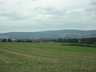
| View of the Weiden basin and Fischerberg from the west | |||
| Systematics according to | Handbook of the natural spatial structure of Germany | ||
| Greater region 2nd order | 07 → Upper Palatinate-Upper Main hill country |
||
| About main unit | 070 → Upper Palatinate hill country |
||
| Geographical location | |||
| Coordinates | 49 ° 37 '9 " N , 11 ° 59' 32" E | ||
|
|||
| circle | Neustadt an der Waldnaab , Weiden in the Upper Palatinate , Amberg-Sulzbach district | ||
| state | Bavaria | ||
| Country | Germany | ||
The Weiden basin is a natural subunit in the northern Upper Palatinate hill country . The Weidner basin is one of the Northeast Bavaria on the southwestern edge of the Bohemian Massif located Permokarbonvorkommen . The Weiden Basin consists of the Weiden Bay in the southeast and the Erbendorfer Trog in the northwest.
Natural allocation and structure
The Weiden basin is a subordinate natural area in the north of the Upper Palatinate hill country .
Since sheet 154/155 Bayreuth of the single sheets 1: 200,000 for the manual of the natural spatial structure of Germany has not been published, there is no detailed breakdown for the northern part of the Upper Palatinate hill country . However, the Weiden Basin is regularly mentioned in relevant specialist literature as a natural area.
Natural sub-units:
- Weidener Bay
- Erbendorfer trough
geology
The Rotliegend sediments of the Weiden Basin were created in a desert climate from the erosion debris of the Variscan Mountains following the tropical to subtropical Carbon Age in which extensive swamp forests were to be found in the area of the Weiden Basin.
Individual evidence
- ↑ Harald Dill: Statigraphy and lithology of permocarbons in the Weiden basin (NE Bavaria, BR Germany) . In: Journal of the German Geological Society . 141 (part 1), 1990, pp. 31-47 .
- ↑ H. Dill, J. Ruhland, M. Teschner, H. Wehner: First discovery of hydrocarbons in the Permo-Carbon of the Weiden basin (NE Bavaria). In: researchgate.net. Association of Friends of Mineralogy and Geology, District Group Weiden, accessed on January 9, 2015 .
- ^ Stefan Glaser, Gertrud Keim, Georg Loth, Andreas Veit, Barbara Bessler-Veit, Ulrich Lagally: Geotopes in the Upper Palatinate . Ed .: Bavarian State Office for the Environment. 1st edition. 2007, ISBN 978-3-940009-92-0 , pp. 47 .
- ^ Dietrich Jürgen Manske: Geographical land survey: The natural space units on sheet 164 Regensburg. Federal Institute for Regional Studies, Bad Godesberg 1981, pp. 53–54. → Online map (PDF; 4.8 MB)
- ^ Berthold Weber: The Weidener Bay. In: vfmg-weiden.de. Association of Friends of Mineralogy and Geology, District Group Weiden, accessed on January 3, 2015 .

