
Naab
| Naab | ||
 Course of the Naab east of the Franconian Alb |
||
| Data | ||
| Water code | EN : 14 | |
| location | Upper Palatinate , Bavaria ( Germany ) | |
| River system | Danube | |
| Drain over | Danube → Black Sea | |
| origin | The confluence of Haidenaab and Waldnaab approx. 9 km south of Weiden idOpf. 49 ° 36 '11 " N , 12 ° 7' 57" E |
|
| Source height |
394 m above sea level NN (at the confluence) |
|
| muzzle | At Regensburg -Mariaort in the Danube Coordinates: 49 ° 0 '59 " N , 12 ° 1' 49" E 49 ° 0 '59 " N , 12 ° 1' 49" E |
|
| Mouth height | 333 m above sea level NN (DTK25) | |
| Height difference | 61 m | |
| Bottom slope | 0.31 ‰ | |
| length |
196.6 km together with the Waldnaab |
|
| Catchment area | 5,514.14 km² | |
| Discharge at the Heitzenhofen A Eo gauge : 5432 km² Location: 17 km above the mouth |
NNQ (09/01/1929) MNQ 1921–2006 MQ 1921–2006 Mq 1921–2006 MHQ 1921–2006 HHQ (02/06/1909) |
7.91 m³ / s 17.8 m³ / s 49.9 m³ / s 9.2 l / (s km²) 310 m³ / s 950 m³ / s |
| Discharge at the mouth of the A Eo : 5,514.14 km² |
MQ Mq |
50.3 m³ / s 9.1 l / (s km²) |
| Medium-sized cities | Pastures in the Upper Palatinate , Schwandorf | |
 Source of the Fichtelnaab |
||
The Naab is a left tributary of the Danube in the Upper Palatinate in Eastern Bavaria , Germany, flowing in a southerly direction .
It arises from the confluence of the Haidenaab, coming from the northwest, and the more water-rich Waldnaab, flowing from the north . With this left source river over 99 kilometers long, the Naab is about 197 km long. From its 5514 km² catchment area , it supplies the Danube with 50.3 m³ / s of water, making it the largest left Danube tributary above Vienna .
Surname
The name is derived from the Indo-European word nebh , which means 'moist' or 'water'. In the year 700 one wrote "Nabas", 885 "Napa", 1005 "Naba", 1199 "Nabe", 1245 "Nab" and from 1546 "Naab".
River course

The Naab arises west of the Upper Palatinate Forest around nine kilometers as the crow flies south of Weiden near Unterwildenau from the union of Haidenaab (around 6.5 m³ / s; from right) and Waldnaab (around 10.4 m³ / s; from left). Then it runs southwards along the A 93 and the B 15 , later the B 8 , including via Schwandorf and Burglengenfeld . It flows into the Danube at Mariaort near Regensburg from the left , just below the Schwarzen Laber and around five kilometers as the crow flies west of the confluence of the Regen into the Danube.
Until 1304, the Naab in the Regensburg area flowed east of the Danube arc for a few kilometers on the left for several kilometers parallel to the Danube, merged south of Stadtamhof with the rain running from north to south and then a little further southeast with the Danube. A contiguous, narrow headland ran between Naab and Danube , of which the two Danube islands Oberer Wöhrd and Unterer Wöhrd still exist today after two breakthroughs in the urban area of Regensburg .
After the second breakthrough as a result of a huge flood catastrophe in 1304, the mouth of the Naab shifted several kilometers to the west to where it currently flows into the Danube, southwest of the Danube arch near Mariaort. Thus the last piece of the original Naab river bed in the urban area of Regensburg became today's second, northern arm of the Danube. Both arms of the Danube were separated by a few islands, which were redesigned several times over the centuries, so that there are only two of them today - the Upper Wöhrd in the west and the Lower Wöhrd in the east.
The northern branch of the Danube, which was created after the breakthroughs, i.e. the former river bed of the Naab, initially carried more water than the southern branch of the Danube. This endangered the use of the ship landing sites in the city of Regensburg on the southern branch of the Danube. Because unhindered shipping and the monetary income from land and customs rights were vital for the city, hydraulic engineering measures at the westernmost tip of the Upper Wöhrd near Pfaffenstein at the so-called weir hole changed the flow conditions so that the southern arm of the Danube was supplied with more water than the northern one, which led past the landing sites created later by the Duke of Bavaria. The defensive hole became a bone of contention between the imperial city of Regensburg and the Duchy of Bavaria. Both tried again and again to dig water from each other through hydraulic engineering.
Source rivers and tributaries of the same name of the Naab
- Haidenaab : The right and western source river of the Naab rises in the Fichtelgebirge .
- Waldnaab : The left, eastern and longest source river of the Naab drains the area between the Fichtelgebirge and the Upper Palatinate Forest .
- Fichtelnaab : The right and richer source river of the Waldnaab has its source in the Fichtel Mountains .
- Tirschenreuther Waldnaab: The left and longer source river of the Waldnaab rises in the Upper Palatinate Forest.
- Schweinnaab : a right and western tributary of the Waldnaab. The source is about ten kilometers northwest of Parkstein , the mouth in Weiden.
- Dürrschweinnaab : This smallest Naab flows into the Sauerbach from the right near Altenstadt-Haidmühle, which in turn flows into the Schweinnaab. The source of the Sauerbach is northwest of Altenstadt , the mouth above Weiden.
Tributaries
The largest tributaries in the sequence of their mouths into the Naab with inflow direction, mouth discharge, length and catchment area:
- Luhe , left, 1.45 m³ / s, 26 km, 153.96 km²
- Ehenbach , right, 0.81 m³ / s, 18.5 km, 107.39 km²
- Fensterbach , right, 0.66 m³ / s, 29.6 km, 102.57 km²
- Pfreimd , left, 6.0 m³ / s, 76.5 km, 595.05 km²
- Schwarzach , left, 8.7 m³ / s, 95 km, 841.45 km²
- Vils , right, 7.8 m³ / s, 87.4 km, 1238.74 km²
Neighborhoods
Cities, market communities and municipalities through which the Naab flows or is touched, in the order of the first contact from the confluence of the Wald- and Haidenaab:
Neustadt an der Waldnaab district
- Luhe-Wildenau market
- Wernberg-Koeblitz market
- City of Pfreimd
- City of Nabburg
- Municipality Schwarzach bei Nabburg
- Stulln municipality
- Schwarzenfeld market
- City of Schwandorf
- City of Teublitz
- City of Burglengenfeld
- Kallmünz market
- Duggendorf municipality
- community Pielenhofen
- Brunn municipality
- Laaber market
- Market Nittendorf
- community Pettendorf
- community Sinzing
Picture gallery

Waldnaab and Haidenaab merge to form Naab (2016)
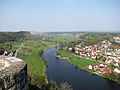
Naab near Kallmünz
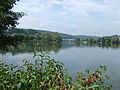
Confluence of the Naab (back right) into the Danube (front left)


Others
The river or the Naabtal has become known since 1988 through the Original Naabtal Duo and their hit Patrona Bavariae .
literature
- Franz X. Bogner: The Naab - with Waldnaab, Fichtelnaab, Haidenaab. (2004) Luftbildband, 132 pages, Pustet, Regensburg, 2004. ISBN 3-7917-1915-7
- The Naab - life on the river through the ages. (1998) Buch & Kunstverlag Oberpfalz, Amberg, ´ ISBN 3-924350-93-0
- Dietmar Herrmann: The Ochsenkopf in the Fichtelgebirge , issue 17/2009 of the series Das Fichtelgebirge (FGV)
Web links
- Course and catchment area of the Naab on the BayernAtlas
- http://www.bayern-fichtelgebirge.de/gewaesserkunde/3.htm?3
Individual evidence
- ↑ BayernAtlas, DTK25: mouth of the Naab to the Regensburg barrage (+ scroll up the Danube to the Bad Abbach barrage)
- ↑ a b c Directory of brook and river areas in Bavaria - Naab river area, page 1 of the Bavarian State Office for the Environment, as of 2016 (PDF; 4.0 MB)
- ^ Deutsches Gewässerkundliches Jahrbuch Danube region 2006 Bavarian State Office for the Environment, p. 152, accessed on October 4, 2017, at: bestellen.bayern.de (PDF, German, 24.2 MB).
- ↑ Water level Heitzenhofen increased by the drainage of the remaining catchment area (6.5l / s.km² to 80.44 km²), determined for the enclosing intermediate catchment area of the Kelheimwinzer (Danube), Deuerling (Schwarze Laber), Heitzenhofen (Naab), Marienthal (Regen ) and Schwabelweis (Danube), as well as from the Hydrological Atlas of Germany - Annual discharge height
- ↑ Wolf-Armin Frhr. v. Reitzenstein : Lexicon of Bavarian place names. Origin and meaning . CH Beck, Munich 2006, ISBN 3-406-55206-4 , p. 174 .
- ↑ Gauge values Windischeschenbach (Waldnaab) and Wildenau (Haidenaab) increased by the drainage of the remaining catchment areas (8l / s.km²), determined for the enclosing intermediate catchment area of the gauges Windischeschenbach , Wildenau , Kettnitzmühle (Ehenbach) and Unterköblitz (Naab)
- ↑ Alois Schmid: Kneiting in prehistory and in the Middle Ages . In: Negotiations of the historical association for Upper Palatinate and Regensburg . tape 153 . Historical Association for Upper Palatinate and Regensburg, 2013, ISSN 0342-2518 , p. 42 f .
- ^ Karl Bauer: Regensburg. Art, culture and everyday history . MZ-Verlag, Regensburg 2014, ISBN 978-3-86646-300-4 . P. 451.