
Duggendorf
| coat of arms | Germany map | |
|---|---|---|

|
Coordinates: 49 ° 7 ' N , 11 ° 56' E |
|
| Basic data | ||
| State : | Bavaria | |
| Administrative region : | Upper Palatinate | |
| County : | regensburg | |
| Management Community : | Kallmünz | |
| Height : | 338 m above sea level NHN | |
| Area : | 22.88 km 2 | |
| Residents: | 1577 (Dec. 31, 2019) | |
| Population density : | 69 inhabitants per km 2 | |
| Postcodes : | 93182, 93195 | |
| Primaries : | 09473, 09409, 09498 | |
| License plate : | R. | |
| Community key : | 09 3 75 131 | |
| Community structure: | 19 districts | |
| Association administration address: | Keltenweg 1 93183 Kallmünz |
|
| Website : | ||
| Mayor : | Thomas Eichenseher ( CSU ) | |
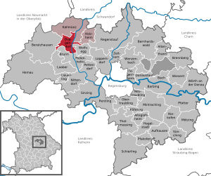
| Location of the community of Duggendorf in the district of Regensburg | ||
  |
||

Duggendorf is a municipality and a village of the same name in the Upper Palatinate district of Regensburg and a member of the Kallmünz administrative community . The main town is the village of the same name.
geography
Geographical location
The place is on the Naab about 16 kilometers northeast of the city of Hemau .
Community structure
There are 19 districts:
|
history

Duggendorf


The main town was first mentioned in a document in 1270. The name of the settlement appears for the first time in a document in the year 1000 as Tutin village . The name is believed to be derived from the name of the owner, Tuto, mentioned in the relevant document. Between 1140 and 1160 it was mentioned as Tukendorf, 1170 to 1190 Tuschendort, 1318 Tukendorf, 1326 Tukkendorf and 1508 Tugkendorff. In 1665 it became Duggendorf through dissimilation . Duggendorf has been a parish for 500 years. In 1581 Christoph Vogel became the pastor of the newly established pastorate in Duggendorf. The baroque parish church, the gem of Duggendorf, dates back to 1736. Grave slabs on the facade indicate an earlier church with the dates 1521 and 1530. The rococo organ from 1738, which has since been renovated, is worth seeing.
In 1861 the place had 217 inhabitants in 61 households.
The Burgstall Lichtenroth , a lost hilltop castle, is located on the territory of the municipality .
Hochdorf
Hochdorf, which has always belonged to the parish of Duggendorf but was an independent parish, was merged with the former parish of Duggendorf to form a new parish in the course of the territorial reform in 1978. When at the beginning of the 18th century almost the entire population of the village was swept away by the plague, the current branch church was built in honor of St. Sebastian. A castle already existed in Hochdorf in the 16th century. It was owned by the Teuffel von Birkensee . The coat of arms of this family, which is also attached to the parish church in Duggendorf, served as a template for the Duggendorf coat of arms. The castle, built in the 16th century, was rebuilt in the 18th century.
Wischenhofen
The village of Wischenhofen, which was an independent municipality until 1946, also has a castle . Almost nothing is known about the previous owners of the castle and the castle itself. Today it is privately owned by a family. The castle chapel adjoins the north side. It has also been renovated in recent years.
Incorporations
On May 1, 1978, the previously independent community of Hochdorf and from the neighboring community of Wolfsegg the districts of Heitzenhofen, Judenberg, Schwarzhöfe, Weihergut and Zündergut were incorporated. As of January 1, 2014, parts of the disbanded municipality-free area of Pielenhofer Wald on the right of the Naab were incorporated.
Population development
Between 1988 and 2018 the municipality grew from 1,347 to 1,575 by 228 inhabitants or 16.9%.
politics
Municipal council
The municipal council has 12 members. In the local elections on March 15, 2020, 1,302 residents entitled to vote in the municipality of Duggendorf, 1,018 exercised their right to vote, bringing the turnout to 78.19 percent.
mayor
Thomas Eichenseher (CSU) has been the mayor since May 2014. In the local election on March 15, 2020, he was re-elected 63.72% of the vote.
coat of arms
|
|
Blazon : "Above a blue corrugated shield base divided by red and gold, covered with a fire-breathing dragon's body in confused colors."
The coat of arms has been used since 1982. |
Buildings
.jpg)

- Church / plague cross in Hochdorf
- former Hofmarkschloss in Hochdorf
- Heitzenhofen Castle
- Wischenhofen Castle
- Village fountain in Duggendorf
- Church in Duggendorf
- Wolfgang Church
- Plague Cross Neuhof
traffic
- Motorway connection “Regensburg-Nürnberg” on the A 3
- State highways: 2165, 2235
- RVV bus line 12
- RVV bus line 29
societies
- DJK Duggendorf (sports club)
- Catholic women's association
- Hochdorf Warrior Association
- Rifle Club Hubertus Hochdorf e. V.
- TC Hochdorf (tennis)
- Naabtal brass band Duggendorf
- Trachtenkapelle Duggendorf
- VDK local association
- FF Duggendorf
- FF Hochdorf
- FF Wischenhofen
- FF Heitzenhofen
- RK Wischenhofen
- FC Bayern fan club Naabtal
Web links
- [www.duggendorf.de/ Gemeindeverwaltung]
- Duggendorf: Official statistics of the LfStat
Individual evidence
- ↑ "Data 2" sheet, Statistical Report A1200C 202041 Population of the municipalities, districts and administrative districts 1st quarter 2020 (population based on the 2011 census) ( help ).
- ↑ Mayor's office. Municipality of Duggendorf, accessed on June 11, 2020 .
- ^ Community Duggendorf in the local database of the Bavarian State Library Online . Bavarian State Library, accessed on November 28, 2017.
- ↑ Wolf-Armin von Reitzenstein: Lexicon of Bavarian Place Names: Origin and Meaning; Upper Bavaria, Lower Bavaria, Upper Palatinate. 2006, ISBN 978-3-406-55206-9 , p. 61, digitized
- ^ Joseph Heyberger, Chr. Schmitt, v. Wachter: Topographical-statistical manual of the Kingdom of Bavaria with an alphabetical local dictionary . In: K. Bayer. Statistical Bureau (Ed.): Bavaria. Regional and folklore of the Kingdom of Bavaria . tape 5 . Literary and artistic establishment of the JG Cotta'schen Buchhandlung, Munich 1867, Sp. 653 , urn : nbn: de: bvb: 12-bsb10374496-4 ( digitized version ).
- ^ Federal Statistical Office (ed.): Historical municipality directory for the Federal Republic of Germany. Name, border and key number changes in municipalities, counties and administrative districts from May 27, 1970 to December 31, 1982 . W. Kohlhammer, Stuttgart / Mainz 1983, ISBN 3-17-003263-1 , p. 658 and 659 .
- ↑ Bavarian State Office for Statistics and Data Processing (Hrsg.): The municipalities of Bavaria according to the territorial status May 25, 1987. The population of the municipalities of Bavaria and the changes in the acquisitions and territory from 1840 to 1987 (= contributions to Statistics Bavaria . Issue 451). Munich 1991, p. 82 , urn : nbn: de: bvb: 12-bsb00070717-7 ( digitized version - footnote 9).
- ↑ www.regierung.oberpfalz.bayern.de
- ↑ https://wahlen.landkreis-regensburg.de/kommunal2020/20200315/09375131/html5/Gemeinderatswahl_Bayern_66_Gemeinde_Gemeinde_Duggendorf.html
- ↑ https://wahlen.landkreis-regensburg.de/kommunal2020/20200315/09375131/html5/Gemeinderatswahl_Bayern_66_Gemeinde_Gemeinde_Duggendorf.html
- ↑ https://wahlen.landkreis-regensburg.de/kommunal2020/20200315/09375131/html5/Buergermeisterwahl_Bayern_67_Gemeinde_Gemeinde_Duggendorf.html
- ↑ Entry on the Duggendorf coat of arms in the database of the House of Bavarian History , accessed on August 6, 2020 .

Cities: Hemau | Neutraubling | Wörth on the Danube
Markets: Beratzhausen | Donaustauf | Kallmünz | Laaber | Lappersdorf | Nittendorf | Regenstauf | hemlock
Municipalities: Alteglofsheim | Altenthann | Aufhausen | Bach on the Danube | Barbing | Bernhardswald | Brennberg | Brunn | Deuerling | Duggendorf | Hail city | Holzheim am Forst | Köfering | Mintraching | Mötzing | Obertraubling | Pentling | Pettendorf | Pfakofen | Pfatter | Pielenhofen | Riekofen | Sinzing | Sünching | Tegernheim | Thalmassing | Wenzenbach | Wiesent | Wolfsegg | Time warning
Unregulated areas: Forstmühler Forst | Kreuther Forest