
Lappersdorf
| coat of arms | Germany map | |
|---|---|---|

|
Coordinates: 49 ° 3 ' N , 12 ° 5' E |
|
| Basic data | ||
| State : | Bavaria | |
| Administrative region : | Upper Palatinate | |
| County : | regensburg | |
| Height : | 341 m above sea level NHN | |
| Area : | 34.51 km 2 | |
| Residents: | 13,338 (Dec. 31, 2019) | |
| Population density : | 387 inhabitants per km 2 | |
| Postal code : | 93138 | |
| Primaries : | 0941, 09404 | |
| License plate : | R. | |
| Community key : | 09 3 75 165 | |
| LOCODE : | DE LPP | |
| Market structure: | 30 districts | |
Market administration address : |
Rathausstrasse 3 93138 Lappersdorf |
|
| Website : | ||
| Mayor : | Christian Hauner (FW) | |
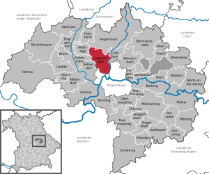
| Location of the Lappersdorf market in the Regensburg district | ||
  |
||


Lappersdorf is a market in the Upper Palatinate district of Regensburg in Bavaria . The market borders the city of Regensburg to the north-west and is an important school location in the district. Lappersdorf is known nationwide primarily for its fire brigade school.
geography
Geographical location
Lappersdorf is located in the Regensburg region just before the river Regen flows into the Danube . The federal motorway 93 (exit Regensburg-Nord) separates the town center from the rain . Lappersdorf borders directly on the Upper Palatinate district capital in the north-west and is often difficult to identify as an independent municipality for non-residents who overlook the place-name sign. The municipality officially bears the name Lappersdorf only since 1958 (previously Oppersdorf).
Community structure
There are 30 districts:
|
There are the districts of Hainsacker, Kareth, Lappersdorf and Schwaighauser Forst.
history
Until the church is planted
Lappersdorf was first mentioned in 1185 as Leutfridestorf. Later it became the official seat and belonged to the Duchy of Neuburg-Sulzbach and its court Hainsacker; since 1777 the area was part of the Electorate of Bavaria. In 1818 today's political community was established, although it was still named after the place Oppersdorf .
Kareth, an old wine-growing region, is first mentioned around 1070 in the traditions of the Mittelmünster monastery. Hainsacker appears around 1140 in the traditions of the convent and is shown in the first documentary mention in 1224 as a "parish". The church in Oppersdorf (as a side church of Hainsacker) is documented as early as the 13th century (four times), for the first time in 1224.
20th century
The municipality of Oppersdorf was renamed the municipality of Lappersdorf on March 19, 1958. As part of the municipal reform that came into force on May 1, 1978, the municipalities of Hainsacker, Kareth and Lappersdorf voluntarily merged to form today's municipality. Lappersdorf was raised to the market on September 20, 1997. As of October 1, 2009, parts of the dissolved, community-free area of Schwaighauser Forst were incorporated.
Population development
Between 1988 and 2018 the market grew from 10,949 to 13,298 by 2,349 inhabitants or 21.5%.

- 1961: 6,645 inhabitants
- 1970: 8,021 inhabitants
- 1987: 10,908 inhabitants
- 1991: 11,312 inhabitants
- 1995: 11,667 inhabitants
- 2000: 12,288 inhabitants
- 2005: 13,850 inhabitants
- 2010: 13,228 inhabitants
- 2015: 13,215 inhabitants
- 2018: 14,036 inhabitants
- 2019: 14,108 inhabitants
coat of arms
|
|
Blazon : “Divided by a lowered golden battlement beam in blue and green; above a crowned silver lion, below a continuous silver wave bar. "
The coat of arms has been in use since 1978 and was designed by the painter Franz Ruhs. |
politics
mayor
The first mayor has been Christian Hauner (FW) since 2014, who was re-elected in the 2020 local elections with an absolute majority of 54.41 percent.
Mayor of the Lappersdorf market:
- –2002 Hans Todt (CSU)
- 2002–2014 Erich Dollinger (CSU)
- 2014– Christian Hauner (FW)
Market council
The municipal council consists of 24 members. In the local elections on March 15, 2020, 7,065 of the 10,800 residents eligible to vote in Markt Lappersdorf exercised their right to vote, bringing the turnout to 65.42 percent.
Culture and sights
Buildings
- Church of St. Egidius in Hainsacker, built from 1737 to 1742
- Parish Church of the Assumption of Mary (hall building in the type of a choir tower church, with flank tower, 1930 by Georg Holzbauer, while retaining the medieval tower; with furnishings)
- Aurelium (cultural center and event hall)
Architectural monuments

Economy and Infrastructure
Economy including agriculture and forestry
In 1998 there were 10 employees in the field of agriculture and forestry, 605 in the manufacturing sector and 389 in trade and transport at the place of work. In other economic sectors 356 people were employed at the place of work subject to social security contributions. There were 3938 employees subject to social security contributions at the place of residence. There was one in the manufacturing sector and 17 in the construction sector. In addition, in 1999 there were 60 farms with an agricultural area of 1854 hectares. 1750 hectares of which were arable land. In the Schwaighauser Forst parcel , even larger amounts of old armaments are suspected.
education
There are several childcare facilities and four general education schools.
In 2018/2019, a total of 416 pupils were taught by 29 teachers in the Lappersdorf elementary and middle school , of which 259 pupils were taught by 14 full-time teachers in the elementary school and 160 pupils by nine full-time teachers in the Hainsacker elementary school . The State. Gymnasium Lappersdorf had 829 students and 65 full-time teachers in the 2018/2019 school year.
State institutions
Lappersdorf is the seat of the Regensburg fire brigade school , the largest of the three Bavarian fire brigade schools and one of the best known in Germany.
_Lappersdorf.jpg)
Web links
- Homepage of the community
- Entry on the coat of arms of Lappersdorf in the database of the House of Bavarian History
Individual evidence
- ↑ "Data 2" sheet, Statistical Report A1200C 202041 Population of the municipalities, districts and administrative districts 1st quarter 2020 (population based on the 2011 census) ( help ).
- ↑ Markt Lappersdorf in the local database of the Bayerische Landesbibliothek Online . Bavarian State Library, accessed on November 28, 2017.
- ^ Parish Lappersdorf - history
- ^ Federal Statistical Office (ed.): Historical municipality directory for the Federal Republic of Germany. Name, border and key number changes in municipalities, counties and administrative districts from May 27, 1970 to December 31, 1982 . W. Kohlhammer GmbH, Stuttgart / Mainz 1983, ISBN 3-17-003263-1 , p. 658 .
- ↑ www.regierung.oberpfalz.de ( page no longer available , search in web archives ) Info: The link was automatically marked as defective. Please check the link according to the instructions and then remove this notice.
- ^ Entry on the Lappersdorf coat of arms in the database of the House of Bavarian History , accessed on August 6, 2020 .
- ↑ Location, facts and figures | Lappersdorf market. Retrieved August 6, 2020 .
- ↑ https://wahlen.landkreis-regensburg.de/kommunal2020/20200315/09375165/html5/Gemeinderatswahl_Bayern_66_Gemeinde_Markt_Lappersdorf.html
- ↑ https://wahlen.landkreis-regensburg.de/kommunal2020/20200315/09375165/html5/Gemeinderatswahl_Bayern_66_Gemeinde_Markt_Lappersdorf.html
- ↑ Archived copy ( memento of the original from August 8, 2014 in the Internet Archive ) Info: The archive link was inserted automatically and has not yet been checked. Please check the original and archive link according to the instructions and then remove this notice.
- ↑ https://wahlen.landkreis-regensburg.de/kommunal2020/20200315/09375165/html5/Gemeinderatswahl_Bayern_66_Gemeinde_Markt_Lappersdorf.html
- ↑ Press report from old arms
- ↑ child care. Market LAppersdorf, accessed on March 27, 2020 .
- ↑ Lappersdorf primary school in the school database of the Bavarian State Ministry for Education and Culture , accessed on March 27, 2020.
- ↑ Middle School Lappersdorf in the school database of the Bavarian State Ministry for Education and Culture , accessed on March 27, 2020.
- ^ Hainsacker primary school in the school database of the Bavarian State Ministry for Education and Culture , accessed on March 27, 2020.
- ↑ State. Gymnasium Lappersdorf in the school database of the Bavarian State Ministry for Education and Culture , accessed on March 27, 2020.

Cities: Hemau | Neutraubling | Wörth on the Danube
Markets: Beratzhausen | Donaustauf | Kallmünz | Laaber | Lappersdorf | Nittendorf | Regenstauf | hemlock
Municipalities: Alteglofsheim | Altenthann | Aufhausen | Bach on the Danube | Barbing | Bernhardswald | Brennberg | Brunn | Deuerling | Duggendorf | Hail city | Holzheim am Forst | Köfering | Mintraching | Mötzing | Obertraubling | Pentling | Pettendorf | Pfakofen | Pfatter | Pielenhofen | Riekofen | Sinzing | Sünching | Tegernheim | Thalmassing | Wenzenbach | Wiesent | Wolfsegg | Time warning
Unregulated areas: Forstmühler Forst | Kreuther Forest
Altenried | Aschach | Bavaria | Benhof | Einhausen | Geiersberg | Gewald | Hainsacker | Harreshof | Hohensand | Hönighausen | Kareth | Kaulhausen | Knee Strike | Landlhof | Lappersdorf | Lorenzen | Oppersdorf | Pielmühle | Rehthal | Rodau | Schinderwies | Schwaighausen | Blackness | Schwerdnermühle | Steinhof | Stettwies | Tremmelhauserhöhe | Unterkaulhausen | Brick hut