
Rain (river)
| rain | ||
.svg) Map of the course of the river |
||
| Data | ||
| Water code | EN : 1522 | |
| location | Germany | |
| River system | Danube | |
| Drain over | Danube → Black Sea | |
| Beginning as rain | Confluence of the Black and White Rain near Pulling (municipality of Blaibach ) 49 ° 9 ′ 33 ″ N , 12 ° 49 ′ 55 ″ E |
|
| Source height |
381 m above sea level NN (553 m S.Regen, 580 m W.Regen) |
|
| muzzle | in the Danube Coordinates: 49 ° 1 '25 " N , 12 ° 6' 28" E 49 ° 1 '25 " N , 12 ° 6' 28" E |
|
| Mouth height | 325 m above sea level NN | |
| Height difference | 56 m | |
| Bottom slope | 0.52 ‰ | |
| length | 107 km only rain
|
|
| Catchment area | 2,878.13 km² | |
| Discharge at the Marienthal A Eo gauge : 2590 km² Location: 29.5 km above the mouth |
NNQ (08/05/1947) MNQ 1901–2006 MQ 1901–2006 Mq 1901–2006 MHQ 1901–2006 HHQ (12/22/1993) |
4.25 m³ / s 11.6 m³ / s 37.7 m³ / s 14.6 l / (s km²) 306 m³ / s 720 m³ / s |
| Discharge at the mouth of the A Eo : 2,880.35 km² |
MQ Mq |
39.5 m³ / s 13.7 l / (s km²) |
| Left tributaries | Perlbach | |
| Right tributaries | Chamb | |
| Big cities | regensburg | |
| Small towns | Cham , Roding , Nittenau | |
 |
||
The Regen ( Řezná in Czech ) is a left tributary of the Danube , which drains large parts of the Bavarian Forest in the Czech Republic and, above all, Eastern Bavaria . Including its main source rivers, it is 190.93 km long and thus, after the Naab, the second longest river in the Upper Palatinate . With an outlet discharge of almost 40 m³ / s, it is, again after the Naab, the second largest left Danube tributary in Germany.
Surname
The Germanic tribes called the river Regana. From the Romans of Castra Regina , later Regensburg , the name was adopted slightly modified as Reganum or Reganus . In the 11th century, during the time of the Nordgau (Bavaria) , the river Regin was written, on a document from 1140 for the first time rain .
There are various research results about the exact meaning and origin of the name, which also do not exclude a Celtic origin. Several places along the river are related to the river name. The city of Regen was probably named after its location on the river. Regen is also part of the place names Regendorf , Regenhütte , Regenpeilstein, Regenstauf and Weißenregen as well as the original name Reginhusen ('houses on the rain') of the Reinhausen district of Regensburg . In contrast, the city of Regensburg itself, which is located in the mouth of the river, is derived from the Latin place name Castra Regina (camp at the rain) and thus only indirectly from the river name.
geography

Catchment area
The rain drains an area of around 2878 km², which includes large parts of the northern Bavarian Forest. The southern foothills of the Upper Palatinate Forest are also in the catchment area of the rain. The longest source river of the Regen, the Great Rain , and its largest tributary, the Chamb , both have their source in the Czech Republic.
Source rivers
From a hydrological and hydrographic point of view, its left upper course Schwarzer Regen and further up its own right upper course Großer Regen lie on the main strand of the river and are only viewed as a by-name of the entire rain. The river bears the attributeless name Regen from the confluence of the Black and White Rain near Pulling between Bad Kötzting and Blaibach , directly below the dam of the Blaibacher See. With the locals, however, the source rivers are all colloquially referred to as "the" rain.
course
The river continues north-west to Cham , where it receives its largest tributary, the Chamb. The rain flows over Roding , Walderbach and Reichenbach to Nittenau . At this point at the "rain knee" it bends to the southwest and comes up to 6 km close to the Naab river . The rain then runs via Regenstauf and Lappersdorf to Regensburg and flows into the Danube as a left tributary .
muzzle
In Regensburg , more precisely near Reinhausen , the rain flows into the Danube. The rain is only used by commercial shipping over the last 530 meters and is designated as a federal waterway , but only with 100 meters of its own river section. The Regensburg lock canal, the so-called Regensburg European Canal , branches off from the Danube at the A 93 motorway bridge, and after a good 2 km it flows into the rain. The section of rain from this canal confluence to the confluence with the northern arm of the Danube above the Regensburg Nibelungen Bridge is recorded by the official Danube river kilometers (km 2379.24 to 2378.82 = rain km -0.09).
Tributaries
From the origin to the mouth, selection:
- Moosgraben (left, Blaibach- Kreuzbach )
- Brushbach (right, near Blaibach- Hochfeld )
- Langgraben (right, near Miltach- Riesel)
- Klinglbach , also Perlbach (left, Miltach)
- Mühlbach (left, near Chamerau - Staning )
- Roßbach (right, Chamerau- Roßbach )
- Grindelbach (right, near Runding - Langwitz )
- Chamb (right, Cham - Altenstadt ), largest inflow of rain
- Quadfeldmühlbach (left, near Cham- Michelsdorf ) (junction)
- Katzbach (right, near Cham- Katzbach )
- Holderbach (right, at Cham- Ponholzmühle )
- Pitzlinger Bach (right, above-opposite Cham- Wulfing )
- Knöblinger Bach (left, near Cham- Untertraubbach )
- Landgraben (right, below-opposite Cham-Wulfing)
- Aubach (right, Pösing )
- Hiltenbach (right, Roding - Mühlau )
- Grundbach (left, Roding- Piendling )
- Kammerweiherbach (right, near Roding- Oberdorf )
- Trübenbach (left, Roding- Kienmühle )
- Hechtbach (left, Roding- Wiesing )
- Perlbach (left, after Roding-Wiesing)
- Höllgraben (left, after Roding- Imhof )
- Geißgraben (left, above-opposite Roding- Dicherling )
- Emisbachl (left, above-opposite Roding-Dicherling)
- Brunnwiesbachl (right, near Roding-Dicherling)
- Markgraben (right, after Roding-Dicherling)
- Zenzinger Bach (right, at Roding- Zenzing )
- Oberraninger Bach (left, near Zell - Oberraning )
- Satzbach (right, opposite Zell-Oberraning)
- Mühlbach (left, at Zell- Unterraning )
- Wolfsgraben (right, near Walderbach - Kirchenrohrbach )
- Perlenbach (left, near Walderbach - Katzenrohrbach )
- Hauser Bach (right, Walderbach)
- Kühbach (left, below-opposite Walderbach)
- Spitalweiherbach (right, to Walderbach)
- Harsbach (left, Reichenbach )
- Pfaffengraben (left, Reichenbach)
- Kaltenbach (right, after Reichenbach- Kienleiten )
- Heinzlbach (left, Nittenau - Tiefenbach )
- Schwemmbach (left, opposite Nittenau- Treidling )
- Sulzbach (right, near Nittenau- Muckenbach )
- Wehrgraben (right, near Nittenau- Bergham )
- Kühgaßbach (left, near Nittenau)
- Reisachbach (left, Nittenau)
- Oedischbach (right, near Nittenau-Bergham)
- Vellenbach (left, before Nittenau- Obermainsbach )
- Schloßgraben (right, near Nittenau- Neuhaus )
- Doblbach (left, near Nittenau- Untermainsbach )
- Frankenbach (left, near Nittenau- Stefling )
- Dellerbach (right, Nittenau- Hengersbach )
- Geiseckbach (left, to Nittenau-Stefling)
- Schwarzer Graben (right, to Nittenau- Weißenhof )
- Edersbach (right, to Nittenau-Weißenhof)
- Brunnmühlbach (right, almost across from Regenstauf - Marienthal )
- Heubach (right, opposite Regenstauf-Marienthal)
- Kuchenpfalter Bach (right, opposite Regenstauf-Marienthal)
- Römergraben (right, below-opposite of Regenstauf-Marienthal)
- Hansbach (right, before Regenstauf- Hirschling )
- Schirmgraben (right, in front of Regenstauf-Hirschling)
- Almersbach (left, before Regenstauf- Hinterberg )
- Süssenbach (left, Regenstauf- Süssenbach )
- Hausbach (right, near Regenstauf-Hirschling)
- Schneidergraben (right, near Hirschling)
- Mühlbach (left, Regenstauf- Heilinghausen )
- Leonberger Graben (right, at Regenstauf- Schwaighof )
- Schergengraben (left, near Regenstauf- Ramspau )
- Karlsteiner Bach (left, near Regenstauf- Kleinramspau )
_Lappersdorf.jpg)
- Stadtmühlbach (left, at Regenstauf- Stadel )
- Ellenbach (left, at Regenstauf- Fidelhof )
- This brook (right, Regenstauf- These brook )
- Wenzenbach (left, Zeitlarn )
- Aschacher Graben (right, Lappersdorf -Benhof)
- Lorenzer Graben (right, near Lappersdorf- Lorenzen )
- Rodauer Graben (right, Lappersdorf)
- Metzenbach (right, Lappersdorf)
Fish stocks
The rain is very rich in fish. : Alone in the Black rains occur following types European eel , chub (chub) , grayling , brown trout , brook trout , barbel , perch , loach , bream (sea bream) , minnow , gudgeon , bream , hazel , pike , huchen , carp , Bullhead , bleak , moderlieschen , nose , rainbow trout , roach , rudd , burbot , tench , tailor , catfish (catfish) , pikeperch . The greatest specialty is the huchen.
Landscapes
On its way the rain flows through several landscapes:
Rain sink
From Zwiesel to Cham, the (black) rain flows through the rain depression that separates the Rear Bavarian Forest in the northeast from the Front Bavarian Forest and the Falkensteiner Vorwald in the southwest. The course of the rain is influenced again and again by the stake , even after the rain sink .
Regentalaue nature reserve
In the Cham-Further Senke between Cham and Pösing the river valley widens sharply, the river meanders in wide loops. The new nature reserve Regentalaue between Cham and Pösing was created here. With around 1427 hectares, the protected area is by far the largest nature reserve in the Upper Palatinate, next to that of the Küni Mountains on the upper reaches of the Regen, which is partly in the Czech Republic . The first 10-hectare reserve south of Cham was 1974. The core area of nature conservation project Regentalaue covers 1,776 ha. Meadow landscape with alder - and pastures lined standing water such as ponds and backwaters is an important refuge for grassland birds . Here you can godwit , snipe and curlew are observed in their breeding habitat, as well as migratory birds like Ruff , Redshank , Greenshank or whooper swans in their draft.
There are other significant occurrences of beaver , black-necked grebe , corncrake , redshank , spoonbill , bluethroat , kingfisher , moor frog , tree frog and yellow-bellied toad . The nature reserve is also an important location for vegetation (e.g. small sedge , rushes ) and rare insects.
There is an observation station with an observation tower in Cham-Untertraubbach.
Rain valley
From Roding, the rain flows through a wide valley floor that separates the Falkensteiner Forest from the Bodenwöhrer Senke. From Stefling the valley narrows increasingly, and at Marienthal it bends to the south. In the narrow section of the valley to Hirschling with its steep slopes, the river hardly meanders. From Hirschling to Regensburg the valley widens again.
The Regental has a warm climate, which is why warmth-loving plants thrive here, which are also found in the Danube region . Outside the narrow valleys there are also warm mountain slopes on which to granite - Grus dry grasslands and pine forests thrive. There are also ravine forests near Stefling Castle and the Stockenfels castle ruins .
The following vegetation areas belong to the rain valley:
- The flowing water
- The oxbow lakes and landfall basins
- The damp banks and the riparian forests
- The dry grasslands and dry slopes
- The silver grass corridors
- The forests (pine and mixed forests and warm canyon forests)
economy
The rain water is used to supply drinking water and to generate energy. The mills on the Regen are still numerous today, although some are no longer in operation and some have fallen into disrepair. Wood processing and paper production are still important industries.
The drift
The rain has been used for rafting since the Middle Ages . From 1847 the river was flowable as far as Zwiesel. On April 12, 1847, the first seven rafts with boards left Zwiesel for Regensburg. In the forests around Zwiesel, so-called “thresholds” were created, in which the water from the tributaries was dammed. The Kleine Arbersee was also used as a reservoir from 1885. Above Zwiesel, the blocks were collected at the Triftsperre cases rake , sorted and then drifted further downstream. Most feared was the “Bärnloch”, a four-kilometer stretch above Teisnach that was littered with boulders. There the trunks by the hundreds regularly get caught and first had to be cleared again. Some "Dutch tribes" reached the Netherlands via Regensburg and the Ludwig-Danube-Main Canal . Apart from boards and logs, logs were also lifted.
The rafting to Regensburg and Cham came to an end with the construction of the Höllensteinsee in 1926. The Trift lasted until the end of the 1950s. Most recently, it was particularly important from the Zwiesel area to the Teisnach paper factory , until it ended with the construction of the Regener See in 1955.
tourism
Tourism on the rain is becoming increasingly important. The region around Nittenau is the local recreation area of Regensburg, the Regen is known as one of the most beautiful boat rivers in Germany and offers a good infrastructure for canoeists. There is an extensive network of trails for hikers and cyclists.
photos

The rain valley near Pösing during one of the regular floods

The rain at Roding
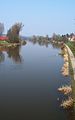
The rain at Reinhausen (north of Regensburg) at the mouth


Missing documentation
While water code numbers (GKZ) were documented in freely accessible directories for small and very small streams in Bavaria , it behaves very differently when it rains. Of the 74 larger tributaries of the rain, only 6 are designated with a GKZ in the water directory Danube from the Naab to the Isar of the Bavarian State Office for the Environment :
- Klinglbach (GKZ = 152272)
- Chamb (GKZ = 15228)
- Knöblinger Bach (GKZ = 152292)
- Perlbach (GKZ = 152294)
- Sulzbach (GKZ = 152296)
- Wenzenbach (GKZ = 152298)
In addition, there is no extra file for the rain and its tributaries, as is the case for some other larger tributaries of the Danube, namely for the Lech , Naab , Isar and Inn .
literature
- Franz X. Bogner: The rain. An aerial portrait from the Arber to Regensburg. Pustet, Regensburg 2007, ISBN 978-3-7917-2054-8 (illustrated book).
- Bärbel Kleindorfer-Marx (Ed.): The rain. Culture and nature on the river. Buch & Kunstverlag Oberpfalz, Amberg 1996, ISBN 3-924350-56-6 .
Web links
Individual evidence
- ↑ a b c d Directory of creek and river areas in Bavaria - Naab to Isar river area of the Bavarian State Office for the Environment, as of 2016 (PDF; 2.8 MB)
- ^ German Hydrological Yearbook Danube Region 2006 Bavarian State Office for the Environment, p. 166, accessed on October 4, 2017, at: bestellen.bayern.de (PDF, German, 24.2 MB).
- ↑ Marienthal gauge value increased by the drainage of the remaining catchment area (6.5l / s.km² to 266.95 km²), determined for the intermediate catchment area of the Kelheimwinzer (Danube), Deuerling (Schwarze Laber), Heitzenhofen (Naab), Marienthal (Regen) gauges and Schwabelweis (Danube), as well as from the Hydrological Atlas of Germany - Annual discharge height
- ↑ a b c Lengths (in km) of the main shipping routes (main routes and certain secondary routes) of the federal inland waterways ( memento of the original from January 21, 2016 in the Internet Archive ) Info: The archive link was automatically inserted and not yet checked. Please check the original and archive link according to the instructions and then remove this notice. , Federal Waterways and Shipping Administration
- ↑ Directory E, Ser. No. 44 and 6 of the Chronicle ( Memento of the original from July 22, 2016 in the Internet Archive ) Info: The archive link was inserted automatically and has not yet been checked. Please check the original and archive link according to the instructions and then remove this notice. , Federal Waterways and Shipping Administration
- ↑ http://www.regierung.oberpfalz.bayern.de/leistungen/umwelt/info/naturschutzgebiete/nsg_cha/regentalaue/066_info.htm
- ↑ Archived copy ( memento of the original dated November 10, 2014 in the Internet Archive ) Info: The archive link was inserted automatically and has not yet been checked. Please check the original and archive link according to the instructions and then remove this notice. .
- ↑ Water registers at www.lfu.bayern.de. Retrieved October 5, 2018.