
Rounding
| coat of arms | Germany map | |
|---|---|---|

|
Coordinates: 49 ° 13 ' N , 12 ° 46' E |
|
| Basic data | ||
| State : | Bavaria | |
| Administrative region : | Upper Palatinate | |
| County : | Cham | |
| Height : | 484 m above sea level NHN | |
| Area : | 20.94 km 2 | |
| Residents: | 2303 (Dec. 31, 2019) | |
| Population density : | 110 inhabitants per km 2 | |
| Postal code : | 93486 | |
| Primaries : | 09971, 09944 | |
| License plate : | CHA, KÖZ, ROD , WÜM | |
| Community key : | 09 3 72 155 | |
| LOCODE : | DE UDG | |
| Community structure: | 21 districts | |
| Address of the municipal administration: |
Kirchstrasse 6 93486 Runding |
|
| Website : | ||
| Mayor : | Franz Kopp ( SPD ) | |
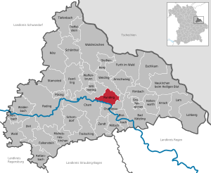
| Location of the municipality of Runding in the district of Cham | ||
  |
||

Runding is a village-dominated community in Oberpfälzer district of Cham . The Runding castle ruins are located on the 545 meter high Schlossberg in Runding .
geography
Geographical location
The municipality of Runding is located in the Upper Bavarian Forest Nature Park at the foot of the Haidstein in the Cham-Further Senke , six kilometers from Cham , eleven kilometers from Furth im Wald and eight kilometers from Bad Kötzting .
Community structure
Runding has 21 parish parts:
|
|
The three districts Niederrunding, Raindorf and Runding exist in the municipality .
history
Origin of the village
Today's Runding was founded around the time from 1340 to 1360, i.e. still under the rule of the Runtinger dynasty, as a settlement of charcoal burners and pitch burners at the foot of the Rundinger castle hill and developed into a parish village over the next hundred years. The village was then called "Pachling".
Church building
The municipal edicts of 1808 and 1818 founded today's political municipalities in Bavaria, including the municipalities of Niederrunding, Raindorf and Runding.
19th century
In 1849 the village of Pachling was hit by a devastating fire that destroyed the church, the schoolhouse and all the properties in the upper village up to the old rectory. Since the people in this remote area of the Bavarian Forest were very poor at that time, the reconstruction of the village was difficult. So the rebuilt church could only be consecrated in 1871. However, the village square was redesigned and generously designed for that time. The Marian column was erected in the middle. It was not until 1880, when Runding castle and estate had long since become meaningless, that the municipal council applied to the royal Bavarian district office of Cham to rename Pachling to Runding. On November 9, 1880, in the official gazette for the royal district offices of Cham, Furth, Nittenau and Waldmünchen, it was announced that King Ludwig II of Bavaria had deigned to graciously approve that the village of Pachling and the hamlet of Runding were now only named "Runding" may be performed.
Second World War
Josef Bergmann was mayor of Runding during World War II. At the end of the war, in autumn 1944, employees of the Hungarian Ministry of Finance and their families had moved into the Rundinger school with over 100 people on the run from the Red Army. Some of them stayed in Runding until the currency reform . Some of them later returned to Hungary, some emigrated to the USA. Some of them still visit acquaintances and friends in Runding today.
After the Second World War
After the end of the war, the US Army appointed Josef Kiefl from Runding as mayor. In the first elections after the establishment of the Federal Republic of Germany, Wolfgang Beer was elected head of the community. In 1953, Mayor Beer suffered a stroke at a town hall meeting for the final report on the construction of the water pipeline from Roßberg (Bärndorf, municipality of Chamerau) to the water reserve at Schlossberg and died. In the old school, the population should be informed about the construction of the water supply for Runding and Maiberg.
Castle Festival
In the 1950s, castle festivals were held twice on the grounds of the Runding ruins. A piece by the Nuremberg poet Hans Sachs was played each time . The lords of the castle were Karl Beer and Adolf Bierl, the damsels embodied Maria Kiefl and Anna Griesbeck. The historical costumes were loaned from Baron von Schacky from Waffenbrunn . Although the festival was well attended, it was no longer continued for financial reasons.
First ladies fire department in Bavaria
In 1965, Bavaria's first ladies' fire extinguishing group was founded in Runding, which the Bild newspaper and ZDF reported in April 1967. During an exercise in the barn of Mayor Karl Beer, a member of the German armed forces was hired by television to set off smoke bombs. During the demonstration, the hay caught fire in the barn while the ladies fire brigade was practicing on the street outside. Mayor Beer and Richard Baumann who was present were able to put out the fire with the garden hose. The Bundeswehr member suffered a faint attack and had to be hospitalized. The ladies' fire department did not intervene because they thought the whole thing was a performance for the media.
Mayor Karl Beer
Karl Beer was elected as mayor of the municipality of Runding in 1956, at the age of 26 the youngest mayor in Bavaria. He directed Runding's fortunes for 22 years. Under his direction, the water pipeline was extended to include Lufling, which enabled the higher-lying districts of Runding, Lufling and Maiberg to be supplied with drinking water. Even today, half of the demand is still covered by simple pumping (without pumps) using hydraulics from one mountain (Roßberg) through the valley in front of Lederdorn to another (water reserve at Schlossberg Runding).
Through skilful negotiations, Karl Beer realized the acquisition, development and development of the Runding West I building area at the foot of the Schlossberg, the former residence of the Runding noble families. The population of Rundings grew by 200 inhabitants. Beer was also able to acquire the space for another building area. Another important decision by Beers and his local council was to connect the water supply to the Chamer Gruppe association. The original supply was sufficient for only 60 connections to the high-rise houses, even if the water pressure was not particularly high. Without setting the course for the water supply, further residential development would hardly have been possible.
On January 1, 1972, the previous communities of Runding, Niederrunding and Raindorf joined together voluntarily under his direction. In 1978, in response to a protest from the local council, as part of a further regional reform in Bavaria, an administrative partnership was formed with the community of Chamerau (based in Chamerau). As a result, Mayor Beer stopped running in the 1978 local elections.
In 1993 the administrative employee Karl Beer retired after 40 years as mayor and as an employee of the community. Markus Schiedermeier was hired in the administration as his successor. The municipal administration was able to win Karl Beer as archivist. He is working on setting up a community archive for the old communities of Niederrunding, Raindorf and for Runding.
Mayor Alfred Graf
Alfred Graf became the new mayor. During his tenure, the kindergarten was built in 1982 and the Runding West II building area was sold to the Schierer company from Cham. In 1980 the administrative community Chamerau-Runding was dissolved again.
Mayor Willibald Hastreiter
In 1984 Willibald Hastreiter (CSU) from Niederrunding won the election against the previous incumbent Alfred Graf (SPD). Extensive construction work began with the Hastreiter era. First the debt was reduced to 0 DM and a new building yard was built. In 1989 the sewer system started (total volume 23 million DM). The first thing that was built was the sewage treatment plant in Perwolfing. A heated discussion broke out about the location after Hofbauer, the second mayor of the neighboring community of Cham, questioned the location near Selling. Because of the expected odor nuisance, he started a signature campaign against the location near Perwolfing. After a one-year delay, the system was built at the planned location. Little by little the whole western slope of the community was opened up. Around 15 million German marks were built up to 1998. After a construction period of eight years, the water management office recommended that only sewers be built in the separation system. Therefore, new sewage pipes had to be installed. The districts of Lufling, parts of Runding, Rieding and Raindorf were affected.
With the increased construction activity, the debt rose to the district average and beyond. In Runding (1989) and Raindorf (1996) new fire stations were built with great contributions from the population. A knitwear factory was established in Runding, which the Catholic Ichthys community later moved into. In 1994, in fulfillment of the Runding – Raindorf incorporation agreement from 1973, the Runding – Rieding connection road was expanded.
The municipality participated in the Niederrunding land consolidation with extensive road construction measures. The mayor's aim was to create a developed asphalt road for access to every house if possible.
In 1996, after long discussions in the local council, the Runding kindergarten was added, and in the same year the “Am Schmidacker” building area was developed. In 1999, the next development plan followed, the "Schietanger" with a total of 30 new plots. In 2004 the community had 23 ?? Residents. The two former mayors Fritz Maier (former municipality of Raindorf) and Alfred Graf were made honorary citizens of Runding in 1996, former mayor Karl Beer and clergyman Karl Schmid followed in 2000 and 2002.
Mayor Franz Piendl
On May 1, 2008, Franz Piendl (CSU) took over the office of Willi Hastreiter, who was no longer a candidate. In 2014 he was re-elected, and in the election on March 15, 2020, he lost 46.1% of the vote. The school gymnasium, which has existed since 1969, was completely renovated. During his tenure, the sewer system in the municipality of Runding was also completed. In the second period the community built an extension for a crèche to the existing kindergarten. In the years 2013 to 2016, the Langwitz industrial park was expanded. The companies Bauer Walter GmbH & Co. KG and Bayerwald Leasing settled here.
Safe in the old church
In an association, Mayor Willi Hastreiter campaigned for the preservation of the old village church in the center of Runding, which was initially to be demolished. When Mayor Hastreiter and the school caretaker, Klement Mühlbauer, wanted to dispose of the old church safe, something rattled inside the safe. The caretaker tried to open the safe for several hours. Finally the container was opened, monstrances and a drop of blood from "Brother Konrad" came to light. Mühlbauer therefore brought Pastor Karl Schmid to inspect the contents of the safe. He replied to the caretaker: "Wait, I'll get the key".
Chronicle for the villages of Raindorf, Rieding and Vierau
In 2012, Ferdinand Engl from Lederdorn, a native of Rundinger, published a chronicle of the homeland and houses of the villages of Raindorf, Rieding and Vierau. The work presents the history and the owners and residents of the individual houses in detail over the past two hundred years. In 2014 Ferdinand Engl published a house chronicle of the former municipality of Niederrunding according to the same system.
Incorporations
On January 1, 1972, the municipalities of Niederrunding and Raindorf voluntarily joined the municipality of Runding.
Population development
Between 1988 and 2018 the community grew from 2,109 to 2,317 by 208 inhabitants or 9.9%. The population of the municipality of Runding has been over the years:
| year | 1840 | 1871 | 1900 | 1925 | 1939 | 1950 | 1961 | 1970 | 1987 | 1993 | 2001 | 2005 | 2010 | 2015 | 2020 |
| Residents | 1158 | 1327 | 1945 | 1786 | 1712 | 2099 | 1855 | 2009 | 2121 | 2167 | 2287 | 2373 | 2305 | 2295 | 2320 |
politics
Municipal Council 2014
14 voluntary citizens sit on the municipal council. The municipal council election on March 16, 2014 led to the following result with a turnout of 72.0%:
| Political party | Share of votes | Seats |
| CSU | 36.5% | 5 |
| SPD / Free Voting Community | 36.0% | 5 |
| Free voter community Niederrunding | 15.4% | 2 |
| Free electorate Rieding | 12.1% | 2 |
Municipal Council 2020
14 voluntary citizens sit on the municipal council. The municipal council election on March 15, 2020 led to the following result with a turnout of 72.7%:
| Political party | Share of votes | Seats |
| CSU | 32.9% | 4th |
| SPD / Free Voting Community | 35.8% | 5 |
| Free voter community Niederrunding | 18.5% | 3 |
| Free electorate Rieding | 12.7% | 2 |
mayor
The mayors of Runding
- 1945–1946 Josef Kiefl
- 1946–1953 Wolfgang Beer
- 1953–1956 Xaver Schätz
- 1956–1978 Karl Beer (CSU)
- 1978–1984 Alfred Graf (SPD)
- 1984-2008 Willibald Hastreiter (CSU)
- 2008–2020 Franz Piendl (CSU)
- since 2020 Franz Kopp (SPD / Free Voting Community)
Kopp was elected on March 15, 2020 with 53.9% of the vote.
coat of arms
The coat of arms was approved on January 25, 1980 by decision of the government of the Upper Palatinate .
Blazon : Split; in front three narrow golden posts in red, behind in gold a blue bar.
The coat of arms unites the symbols of the two noble families that characterize the municipality. The three golden stakes in red in the front half represent the Runtinger family, a family of ministers that was first documented in connection with Runding Castle in 1118 in the entourage of the Margraves of Cham. The blue bar in gold in the back half shows the family coat of arms of the Notthracht , which took over the ownership share from Michel Runtinger in 1413 and exercised rulership rights until 1829, most recently in the patrimonial Runding court.
Culture and sights
Runding Castle

The Runding castle ruins are located on the Schlossberg . It was first mentioned in 1118 and was once the largest castle complex in the Bavarian Forest. The Runtinger (Roumptinger) probably built the first castle around 1100, the oldest finds from archaeological excavations date from the 10th century. In 1118 the two Runtinger brothers, Rudiger and Adalbert, were mentioned as ministerials of the Margraves of Cham. After the extinction of Runtinger to 1413, the ministerial family took Notthafft the castle as a fief of the Dukes of Bavaria-Straubing . The Notthphia family expanded the castle in the 15th and 16th centuries until it had a total built-up area of around 15,000 square meters. Around 1430 the castle and the surrounding villages had to survive the Hussite invasions and during the Thirty Years War the castle was plundered by Swedes in 1633 and 1641. Due to financial difficulties in 1829, the Bavarian state acquired the Runding estate and the castle. Shortly afterwards, the court banker Hirsch from Munich bought the entire property, but did not take care of the castle. Hirsch sold the Schlossberg with the castle in 1858 to a farmer from Runding. The castle was already largely uninhabitable back then, so the farmer removed the oak planks from the roofs, the windows and the lintels and sold them. The ruins subsequently served the Rundingers as a quarry. On November 13, the place was renamed from Pachling to Runting by a decree of the royal district office Cham.
It was not until 1996 that the municipality began its first maintenance measures. There is an association that supports these measures and attempts are being made to dig up the old castle complexes again. Archaeological excavations have been underway since 1999 under the direction of the medieval archaeologist Bernhard Ernst from Bamberg. The aim is to create an archaeological open-air museum after the main castle has been completely uncovered. During the excavations in 2010, the archaeologist Bernhard Ernst discovered human bones in the chapel below the summit rock in the chancel. A triangular indentation was made in the rock under the former location of the altar and the bones were kept. According to Sperl, it is a human lower and thigh bone. It has been suggested that relics from the former castle chapel were found here. When examining a woman's bones, however, it was found that the person was born between 1500 and 1600. At the end of 2011, the excavations by Bernhard Ernst were completed and a "History Trail Burgruine Runding" set up on 10,000 m². The castle ruins are now accessible at all times, the individual rooms and parts of the castle ruins are explained on 61 DIN-A-4 and DIN-A-5 signs. On old views and engravings, the visitor can get an idea of the dimensions of the facility at that time. On eight larger information boards in the residential tower of the complex, information is given on the history of the owners, the castle during the war, everyday life in the Middle Ages and the history of the building. From May to September, guided tours are offered every Sunday at 10.30 a.m. The Runding castle ruins have become a popular attraction for tourists and the local population. In 2014, 2015 and 2016 further walls in the outer bailey and in the entrance area to the main castle were renovated.
The old parish church of St. Andrew

The substructure of the tower dates from the beginning of the 18th century. The nave, the choir and the upper floors of the tower were rebuilt around 1850. Grave slabs from the 16th century were embedded in the southern and northern outer walls. In the cemetery there is a grave monument made of cast iron plates for Wilhelm Cajetan Nothracht von Weißenstein († 1807).
In Runding, the community has always paid for the bells and the maintenance of the church clock. For this purpose, the sacristan collected the so-called sheaf of bells from the community citizens every year . These are components of the Kornmandln established earlier. Today the community takes care of the maintenance of the tower clock on the old church.
The new parish church of St. Andrew
In 1978 a new church was built. Two years later, Karl Schmid was introduced to his office as the successor to Pastor Simon Kiermeier. The new church was designed with a monopitch roof across the slope and with gray fiber cement panels, which is rather unusual for a building in the Bavarian Forest. The shape of the roof follows the slope of the slope, so that the structure blends in well with its surroundings despite its enormous mass. Some baroque figures from the 18th century that were removed from the old parish church are integrated into the interior of the church. The largest piece of furniture is the Vleugels organ (II / 36 registers), built in 1998 , with artistic coloring by Jacques Gassmann .
Cabaret
The Liederbühne Robinson, founded in Munich in 1976, has been located in Runding-Vierau since 1989 .

Architectural monuments
Soil monuments
Economy and Infrastructure
Jobs
In 2017 there were 635 jobs subject to social security contributions in the municipality. Of the resident population, 1,033 people were in employment that was subject to compulsory insurance. This means that the number of out-commuters was 398 more than that of in-commuters. 26 residents were unemployed.
Blauberg granite quarry
Granite has been mined in the Blauberg district since 1888. The old quarry is now filled with water; You can fish in the resulting Blauberger See . Until 1967 the quarry was a so-called stone factory for the production of kerbstones and paving stones, then a gravel works. From the turn of the century to the time before the Second World War, up to 200 people worked there. Some of the employees were housed in a specially created workers' settlement, popularly known as "Russia". The number of employees fell sharply with increasing motorization and automation. The Blauberg granite quarry is now owned by Schärdinger Granit AG and the Jos brewery. Baumgartner a foundation. In 2014 the company Rädlinger Blauberg GmbH acquired the quarry.
AZ Formen- und Maschinenbau Niederrunding
In 1960, Willi Gruber, the landlord of Gawitzl (Langwitz), found out that a certain Zängl from Munich wanted to set up his business in the Cham area. The landlord described the advantages of Langwitz's location at its own train station. From this contact and through the mediation of Gruber with the participation of the then Mayor Hiebl from Perwolfing, the company was born. AZ Formenbau with approx. 200 employees in mechanical engineering in the former municipality of Niederrunding. The company contributed to the development of the community with its employees and trade tax payments. Continental AG has taken over all of the company's shares since 2015.
Tourism in the municipality of Runding
Like other places in the district of Cham, Runding began in 1954 with the establishment of an interest group with the development of tourism , which should replace the missing industry. The location of Rundings seemed suitable for this due to the nature park adjacent to the site on the Schlossberg. The work began with the promotion of guest rooms for the reception of holiday guests. Initially there were only 35 guest beds. Contact was made with various travel agencies from Berlin, who advertised Runding. Hiking trails have been created and marked around the place. The board members of the tourist association and beer breweries who delivered beer to Runding donated a total of 32 benches that were set up around the Schlossberg. The Bavarian granite AG Blue Mountain gave the free base stones. The inns were outdated at that time. The community had the access roads and the local thoroughfares expanded and the place got a handsome picture. All restaurants have been renovated and the guest rooms have running water, some with hot water. The municipality of Runding supported the tourist association financially. Local brochures were sent to travel agencies.
Until 1960, the number of guest rooms and overnight stays rose steadily. From 1960, however, there was a lack of further development and maintenance. Due to the lack of interest of the members in the work of the tourist association, the board resigned and the association was dissolved. The local council then decided to set up a local tourist office, which the previous chairman of the tourist board, Karl Schönfelder, was entrusted with managing.
In May 1997, the municipality of Runding hired Eva Färber, its own tourist agency, to take care of the holidaymakers on an hourly basis. She held guest receptions, organized guided hikes, campfires, visits to the restaurants, informed vacationers about interesting things from the place and offered guided tours in the castle ruins. It has been advertised for years in the community brochure Chamer Freizeitland and recently with its own brochure again. The congregation has also been present on the Internet since 1997. Eva Färber left her job in 2004 because she had reached retirement age. The community tried to offer an additional point of attraction for guests through the conservation measures at the Runding castle ruins from 1993 and archaeological excavations from 1999. The aim was to set up an archaeological open-air museum within the next few years. In 2011 the castle area, which is accessible at all times, was inaugurated. Today several thousand guests visit the castle ruins every year, from which one has a wonderful panoramic view from the Chambe valley up to the Haidstein.
In 2015 Runding received the title "State-approved resort"
Number of overnight stays in recent years:
|
|
Schoolhouses
In 1883 a school was built for the first time in Runding. 62 community citizens had gathered to sign for or against the inclusion of so-called annuity capital for the construction of a new school in the village center. 56 community citizens of the male sex spoke out in favor of the project. In 1964, the then mayor Karl Beer acquired 14 hectares of land from the farmer Max Schätz. In 1963 the Runding school association decided to build a modern primary and secondary school there in 1964. In 1969 the new school was ready to move into. It was built according to the plans of the architect Peter Toll from Cham for 2.5 million German marks by a total of 39 companies. A few years after the inauguration, due to a school reform, the pupils in grades seven to nine had to be transported every day to Cham in the secondary school II. In 1978 the State Agricultural School was housed in parts of this school.
At the beginning of the 21st century, with the introduction of the six-year Realschule (R6), as in many rural communities, the fifth and sixth grades were withdrawn to the Cham Hauptschule. The school district was changed by the government of the Upper Palatinate. The remaining four classes were moved to the western wing of the Runding primary school, the eastern wing has been empty since then. After the eastern part of the school had been partially renovated in 2007 and 2008, the municipality also completed the general renovation of the gymnasium in 2010 with energy-efficient renovation of the kindergarten for a total of 1.1 million euros. Since the introduction of the R6, the number of students had steadily decreased slightly; in the school year 2018/19, four full-time teachers taught a total of 79 students.
Day care centers
There is a day-care facility in the municipality with 62 places and 58 supervised children (as of March 1, 2018).
Personalities
- Rosa Tahedl (1917–2006), native writer and teacher, from 1964 lived in Runding
- Helmut A. Binser (* 1980), music cabaret artist
swell
- ↑ "Data 2" sheet, Statistical Report A1200C 202041 Population of the municipalities, districts and administrative districts 1st quarter 2020 (population based on the 2011 census) ( help ).
- ^ Municipality of Runding in the local database of the Bavarian State Library Online . Bayerische Staatsbibliothek, accessed on January 5, 2018.
- ↑ Wittek Leodegar: Runding - former rector of the Runding elementary school (1988)
- ↑ Summary from "Herrschaft und Schloss Runding" (Strasser, Cham)
- ↑ a b c d e Karl Beer, former mayor of Runding and archivist
- ↑ Retrieves of Leodegar Wittek, Runding, in 1997
- ↑ Women's work , on kfv-cham.de, accessed on March 22, 2020
- ↑ Firefighters from the very beginning , on Mittelbayerische.de, accessed on March 22, 2020
- ^ Wilhelm Volkert (ed.): Handbook of Bavarian offices, communities and courts 1799–1980 . CH Beck, Munich 1983, ISBN 3-406-09669-7 , p. 439 .
- ↑ a b c d e Rudolf room: Runding municipal administration
- ↑ Press on the 2020 mayoral election , accessed on August 19, 2020
- ^ Federal Statistical Office (ed.): Historical municipality directory for the Federal Republic of Germany. Name, border and key number changes in municipalities, counties and administrative districts from May 27, 1970 to December 31, 1982 . W. Kohlhammer, Stuttgart / Mainz 1983, ISBN 3-17-003263-1 , p. 641 .
- ^ "Social Studies Runding" - Friedl Karl Josef from Niederrung, 1987
- ↑ 2020 municipal council election , accessed on August 19, 2020
- ↑ Mayoral election 2020 , accessed on August 19, 2020
- ^ District councilor Schiedermeier Heidi
- ↑ Retrieves Willibald Gruber, host of Langwitz, in 1997
- ↑ Continental buys German mold and container specialist AZ , on reifenpresse.de, accessed on March 22, 2020
- ^ Karl Schönfelder, head of the Runding police station in the 1960s
- ↑ Runding is now a "state-approved resort" , on idowa.de, accessed on March 22, 2020
- ↑ Wolfram-von-Eschenbach-Grundschule Runding in the school database of the Bavarian State Ministry for Education and Culture , accessed on August 19, 2020.
literature
- Harald Stark : The Notthracht family - looking for traces in Egerland, Bavaria and Swabia , Weißenstadt 2006, ISBN 3-926621-46-X
Web links
- Runding Castle
- Runding Castle at www.notthracht.de
- Entry on Runding's coat of arms in the database of the House of Bavarian History

Arnschwang | Arrach | Bad Kötzting | Blaibach | Cham | Chamerau | Eschlkam | Falkenstein | Furth in the forest | Gleißenberg | Grafenwiesen | Hohenwarth | Lam | Lohberg | Michelsneukirchen | Miltach | Neukirchen near the Holy Blood | Pemfling | Pösing | Reichenbach | Rettenbach | Rimbach | Roding | Rötz | Rounding | Schönthal | Schorndorf | Stamsried | Tiefenbach | Traitsching | Treffelstein | Weapon Well | Forest | Walderbach | Waldmünchen | Weiding | Willmering | Zandt | Cell