
Hohenwarth (Cham district)
| coat of arms | Germany map | |
|---|---|---|
.svg)
|
Coordinates: 49 ° 12 ' N , 12 ° 56' E |
|
| Basic data | ||
| State : | Bavaria | |
| Administrative region : | Upper Palatinate | |
| County : | Cham | |
| Height : | 506 m above sea level NHN | |
| Area : | 24.22 km 2 | |
| Residents: | 1917 (Dec. 31, 2019) | |
| Population density : | 79 inhabitants per km 2 | |
| Postcodes : | 93480, 93479 | |
| Area code : | 09946 | |
| License plate : | CHA, KÖZ, ROD , WÜM | |
| Community key : | 09 3 72 135 | |
| Community structure: | 19 districts | |
| Address of the municipal administration: |
Schulstrasse 3 93480 Hohenwarth |
|
| Website : | ||
| Mayor : | Xaver Gmach | |
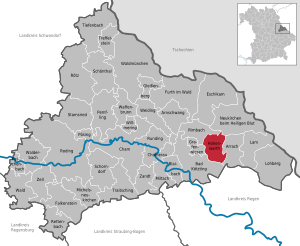
| Location of the community Hohenwarth in the district of Cham | ||
  |
||


Hohenwarth is a municipality in the Upper Palatinate district of Cham . The place of the same name is both the capital and the seat of the municipal administration.
geography
Geographical location
The community is located in the Bavarian Forest in the valley of the White Rain at an altitude of 506 m above sea level. NN between the Hohen Bogen (1079 m) north and the Kaitersberg (1133 m) south.
Community structure
There are 19 parish parts:
There are the districts of Ansdorf, Gotzendorf and Hohenwarth. Since the dissolution of the community of Gotzendorf (January 1, 1972), the Gotzendorf district has been shared with the neighboring community of Rimbach .
history

Until the church is planted
Hohenwarth is mentioned for the first time around 1180 in a document from the Reichenbach monastery . After 1280 the area was owned by the Hohenwarther. In 1402 a closed Hofmark with many rights was created, and a church is also mentioned for the first time. A castle was built in the middle of the century, but it was already in ruins by 1550.
At the beginning of the 15th century, Hans der Hohenwarther gave the property to the Rott monastery . A little later Hohenwarth fell to the Notthracht , from which it was acquired by the Eyb in 1549 . In 1589 Ludwig von Eyb had the current old church built.
In the 17th century, the Hofmark passed to the Kädinger, then the Reittorner, temporarily the Gemmel and finally to the Poyßl. After the Thirty Years War , Hohenwarth Castle was built from around 1650 to 1655 . In 1818 today's political community was established. In 1848 the patrimonial court was repealed. The castle, last owned by the Hafenbrädl, passed into bourgeois hands.
19th and 20th centuries
In 1860 the Church of St. John, which was elevated to a parish church in 1922, was built. From 1978 to 1980 the community was a member of the Grafenwiesen administrative community .
Incorporations
On January 1, 1972, the previously independent municipality of Ansdorf and parts of the municipality of Gotzendorf were incorporated.
Population development
Between 1988 and 2018, the population fell from 2,124 to 1912 by 212 inhabitants or 10%.
- 1961: 1854 inhabitants
- 1970: 1904 inhabitants
- 1987: 2129 inhabitants
- 1991: 2236 inhabitants
- 1995: 2207 inhabitants
- 2000: 2182 inhabitants
- 2005: 2101 inhabitants
- 2010: 2008 inhabitants
- 2015: 1887 inhabitants
- 2020: 1921 inhabitants

politics
mayor
Franz Xaver Gmach has been the mayor since July 2003. He was last elected for another six years on March 15, 2020 with 87.6% of the vote.
Municipal council
In the election on March 15, 2020 , the nominations of the CSU-FWG and the electoral group “Citizens of the Greater Community” each received six seats
coat of arms
|
|
Blazon : "In red on a green three-mountain between two silver church towers with a blue pointed roof, a golden tin tower."
Coat of arms since 1982. |
Culture and sights

- The parish church of St. John the Baptist was built from 1860 to 1862 in neo-Gothic style and has a rich neo-Gothic interior. A painted carpet runs around the high altar on the side walls at window level.
- The old church (castle chapel or cemetery chapel) was completed in 1589. Only the choir remained from the late Gothic complex . It has a baroque altar from the early 18th century, from which some tombstones also come.
- The Hussite Chapel may have its origins in the time of the Hussite Wars .
- The castle, today Vogl Castle Restaurant, was built on the basis of a previous building in the years 1650 to 1655. The complex consists of four wings around a courtyard. The brewery was given up in 1969.
- “Heigl-Linde”, natural monument from the 30 Years War. Michael Heigl's refuge, called the robber Heigl, from his pursuers.
Soil monuments
Economy including agriculture and forestry
In 2017 there were 222 jobs subject to social security contributions in the municipality. Of the resident population, 749 people were in an employment relationship subject to compulsory insurance. This means that the number of out-commuters was 527 more than that of in-commuters. 41 residents were unemployed. In 2016 there were 28 farms; 587 hectares of the community area were used for agriculture.
There is a new industrial park in the Simpering district.
Hohenwarth is a state-approved resort with 17 commercial and private companies; the 2017 statistics show seven establishments with ten or more guest beds and 43,429 overnight stays.
traffic
Road traffic
Hohenwarth is on State Road 2138, which leads from Lam to Bad Kötzting (between Arrach and Grafenwiesen ).
Rail transport
Hohenwarth is on the Lam - Bad Kötzting - Cham line , which is operated by the Upper Palatinate Railway; The Hohenwarth and Hohenwarth campsite stops are in the Hohenwarth area.
education
There are the following facilities:
- Day care center with 67 places and 61 children (as of March 1, 2018)
- Hohenwarth-Grafenwiesen elementary school with 79 students in four classes (school year 2018/19)
Sons and daughters of the church
- Heinrich Brandl (born July 22, 1885 in Simpering, † December 13, 1951 in Bad Kötzting), politician (BVP), member of the Reichstag
- Oswald Fritz (1900–1963), local writer and rector in Hohenwarth
literature
- Harald Stark : The Notthracht family - looking for traces in Egerland, Bavaria and Swabia . Weißenstadt 2006, ISBN 3-926621-46-X .
- Josef Sommerfeldt: "Robber" Heigl. (= Bayerischer Waldgau. Special issue). Bavarian Forest Association, Hohenwarth 1987, OCLC 159877490 .
- Hohenwarther Hefte 1-5, Bayerischer Waldverein, Hohenwarth section
Web links
Individual evidence
- ↑ "Data 2" sheet, Statistical Report A1200C 202041 Population of the municipalities, districts and administrative districts 1st quarter 2020 (population based on the 2011 census) ( help ).
- ↑ Mayor and councilors. Hohenwarth municipality (Cham district), accessed on August 22, 2020 .
- ^ Community Hohenwarth in the local database of the Bavarian State Library Online . Bavarian State Library, accessed on August 3, 2020.
- ^ Wilhelm Volkert (ed.): Handbook of Bavarian offices, communities and courts 1799–1980 . C. H. Beck'sche Verlagsbuchhandlung, Munich 1983, ISBN 3-406-09669-7 . Page 499
- ↑ 2020 municipal council election , accessed on August 15, 2020
- ^ Entry on the coat of arms of Hohenwarth (Cham district) in the database of the House of Bavarian History
- ↑ Hohenwarth-Grafenwiesen primary school in the school database of the Bavarian State Ministry for Education and Culture , accessed on August 15, 2020.

Arnschwang | Arrach | Bad Kötzting | Blaibach | Cham | Chamerau | Eschlkam | Falkenstein | Furth in the forest | Gleißenberg | Grafenwiesen | Hohenwarth | Lam | Lohberg | Michelsneukirchen | Miltach | Neukirchen near the Holy Blood | Pemfling | Pösing | Reichenbach | Rettenbach | Rimbach | Roding | Rötz | Rounding | Schönthal | Schorndorf | Stamsried | Tiefenbach | Traitsching | Treffelstein | Weapon Well | Forest | Walderbach | Waldmünchen | Weiding | Willmering | Zandt | Cell