Chamerau
| coat of arms | Germany map | |
|---|---|---|

|
Coordinates: 49 ° 12 ' N , 12 ° 45' E |
|
| Basic data | ||
| State : | Bavaria | |
| Administrative region : | Upper Palatinate | |
| County : | Cham | |
| Height : | 375 m above sea level NHN | |
| Area : | 23.41 km 2 | |
| Residents: | 2589 (Dec. 31, 2019) | |
| Population density : | 111 inhabitants per km 2 | |
| Postal code : | 93466 | |
| Area code : | 09944 | |
| License plate : | CHA, KÖZ, ROD , WÜM | |
| Community key : | 09 3 72 117 | |
| LOCODE : | DE CMA | |
| Community structure: | 20 districts | |
| Address of the municipal administration: |
Schulstrasse 2 93466 Chamerau |
|
| Website : | ||
| First Mayor : | Stefan Baumgartner | |
| Location of the municipality of Chamerau in the district of Cham | ||
Chamerau is a municipality in the Upper Palatinate district of Cham .
geography
Geographical location
The place is in the Upper Bavarian Forest Nature Park , a few kilometers east of the district town of Cham (Upper Palatinate) .
Community structure
There are 20 districts.
There are four districts in the municipality: Bärndorf, Chamerau, Haderstadl and Lederdorn. Parts of the Haderstadl district are also part of the town of Cham .
history
Until the 19th century
The noble family of Chamerau had their headquarters in Chamerau. A Puchard de Chamerave is documented in 1180. The Chamerauers moved their headquarters to the nearby Haidstein at an early stage and had Chamerau administered by carers .
see also Burgstall Chamerau , Burgstall Haidstein , Roßbach tower
When Albrecht I became Duke of Straubing-Holland when Bavaria was partitioned in 1353, the administration of Lower Bavaria-Straubing was in the hands of the Chamerau people for many years. In 1452 Peter the Chamerauer died. The castle came to the knight Hans Türlinger through marriage in 1474, who sold it to Duke Albrecht IV in 1495 . It fell into disrepair after 1500. In 1811, the carpenter Wolfgang Neumeier von Chamerau bought the ruins from the Bavarian state for 25 guilders. In 1817 many arrows and a gold ring were found when clearing away the walls that were still high as a church tower.
Incorporations
On January 1, 1972, part of the dissolved community of Bärndorf was incorporated. On July 1, 1972, part of the former Haderstadl community was added. Lederdorn followed on July 1, 1976.
Population development
Between 1988 and 2018 the community grew from 2,426 to 2,602 by 176 inhabitants or 7.3%.
politics
mayor
Stefan Baumgartner (CSU / Free Voting Association) has been mayor since May 1, 2008. He was elected for another six years on March 15, 2020 with 94.2% of the vote.
Municipal council
The municipal council has 14 members. At the election on March 15, 2020, the following distribution of seats resulted:
- CSU / Free Community of Voters 5 seats
- SPD / Free Citizens 3 seats
- Interest group Lederdorn 4 seats
- Free voters Chamerau-Lederdorn 2 seats
Compared to the 2014 to 2020 term of office, the CSU / Free Voting Community had to hand over a mandate to the Lederdorn interest group.
coat of arms
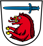
Blazon: a golden armored red boar's body floating in silver under a blue sword lying horizontally. The boar body is borrowed from the coat of arms of the von Chamerau family .
Town twinning
Culture and sights
Buildings
The former Chamerau Castle was the seat of the Lords of Chamerau (first mentioned in 1180). Apart from a few traces (Burgstall, Graben) nothing has survived from the castle.
The parish church of St. Peter and Paul was rebuilt in 1669. The foundation walls of the tower date from the 13th century. In 1960 the church was enlarged with an octagonal extension. The interior contains ceiling frescoes from 1753 and rococo furnishings. The large baptismal font from the 13th century with an apostle frieze is remarkable .
Natural monuments
The so-called “Stone Knight” or “Roßstein”, a cut stone in the rain, forms the background to a well-known legend.
traffic
highway
Chamerau is located on the newly developed federal highway 85 , about ten kilometers from the district town of Cham .
railroad
Chamerau has a stop on the Cham – Lam railway , which is operated by the Upper Palatinate Railway.
Sons and daughters of the church
- Helmut Kiefl (* 1942), politician (CDU), member of the state parliament in Baden-Württemberg from 1996 to 2006
Web links
Individual evidence
- ↑ "Data 2" sheet, Statistical Report A1200C 202041 Population of the municipalities, districts and administrative districts 1st quarter 2020 (population based on the 2011 census) ( help ).
- ^ Community Chamerau in the local database of the Bavarian State Library Online . Bayerische Staatsbibliothek, accessed on January 5, 2018.
- ^ Wilhelm Volkert (ed.): Handbook of Bavarian offices, communities and courts 1799–1980 . CH Beck, Munich 1983, ISBN 3-406-09669-7 , p. 499 .
- ^ Federal Statistical Office (ed.): Historical municipality directory for the Federal Republic of Germany. Name, border and key number changes in municipalities, counties and administrative districts from May 27, 1970 to December 31, 1982 . W. Kohlhammer GmbH, Stuttgart / Mainz 1983, ISBN 3-17-003263-1 , p. 643 .
- ↑ Municipal Council. Municipality of Chamerau, accessed on June 5, 2020 .
- ↑ Municipal Council from May 2020 , accessed on August 14, 2020
- ^ Entry on the coat of arms of Chamerau in the database of the House of Bavarian History


