
Grafenwiesen
| coat of arms | Germany map | |
|---|---|---|

|
Coordinates: 49 ° 12 ' N , 12 ° 53' E |
|
| Basic data | ||
| State : | Bavaria | |
| Administrative region : | Upper Palatinate | |
| County : | Cham | |
| Height : | 439 m above sea level NHN | |
| Area : | 10.2 km 2 | |
| Residents: | 1503 (Dec. 31, 2019) | |
| Population density : | 147 inhabitants per km 2 | |
| Postal code : | 93479 | |
| Area code : | 09941 | |
| License plate : | CHA, KÖZ, ROD , WÜM | |
| Community key : | 09 3 72 130 | |
| Community structure: | 11 districts | |
| Address of the municipal administration: |
Rathausplatz 6 93479 Grafenwiesen |
|
| Website : | ||
| Mayor : | Josef Häring jun. | |
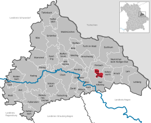
| Location of the Grafenwiesen community in the Cham district | ||
  |
||


Grafenwiesen is a municipality in the Upper Palatinate district of Cham .
geography
Geographical location
The place is north of Bad Kötzting between Kaitersberg and Hohem Bogen . The white rain flows past directly at the place .
Community structure
Grafenwiesen has eleven districts:
|
There are three districts in the municipality : Grafenwiesen, Voggendorf and Rimbach, the latter district is shared with the municipality of Rimbach .
history
Until the church is planted
Grafenwiesen was first mentioned in a document in 1177. In 1217 a Seyfried de Kravewissen was mentioned. The Grafenwiesen were ministerials of the Counts of Bogen and the Margraves of Cham . They were succeeded in 1402 by the Hohenwarther. The Hofmark Grafenwiesen was a fiefdom of the Rott am Inn monastery . From the 16th to the 18th century, various noble families acquired them through inheritance or purchase.
The four-winged Grafenwiesen Castle , which goes back to a medieval building, dates mainly from 1612 to 1620. In 1712, the Rott am Inn Monastery bought back Gut and Hofmark, in whose hands Grafenwiesen remained until the secularization in Bavaria in 1803.
In 1818, Grafenwiesen became a municipality of the Kötzting regional court as part of the second municipal edict .
19th to 21st century
Today's parish church was consecrated on October 14, 1923. A brewery was also located in the castle until 1959 . The castle chapel, built in 1612, served as a place of worship until the new parish church was built in 1923. In 1892 the Kötzting - Lam railway line and the St2140 state road were built. From 1803 to 1918 Grafenwiesen belonged to the parish of Kötzting. Today's parish church was consecrated in 1923.
In 1982 Grafenwiesen became a state-approved resort. The completion of the spa park could be celebrated in 2005.
Administrative community
In 1978 the communities Grafenwiesen, Rimbach and Hohenwarth merged to form the Grafenwiesen administrative community. Hohenwarth retired on January 1st, 1980, and the administrative community was dissolved again in 1994.
Incorporations
On January 1, 1972, the previously independent municipality Voggendorf was incorporated.
Population development
Between 1988 and 2018 the population decreased from 1,553 to 1,519 by 34 inhabitants or 2.2%. On December 31, 1995, the community had 1,695 inhabitants.
politics
mayor
Josef Häring (Independent Voting Association Grafenwiesen) has been the mayor since May 1, 2020; he was elected with 64.0% of the vote. His predecessor Josef Dachs (CSU / Free Voting Community) was in office from May 2002 to April 2020.
Municipal council
In the 2020 to 2026 term of office, the Grafenwiesen municipal council will include seven representatives of the Grafenwiesen Independent Voting Association (UWGG); the CSU / Free Voting Community (CSU-FWG) won five mandates. In the previous term of office, both nominations had each won six seats.
coat of arms
|
|
Blazon : “In blue a silver sloping bar, in it three blue fish; above two six-pointed golden stars, below a jumping silver stag. "
Management since 1978. |
Culture and sights
- The German Match Museum , which opened in 2008, provides information on the history of match manufacture. It also shows excerpts from an extensive special collection of match containers and match labels.
- Another attraction is the open game reserve in the Voggendorf district.
- In the courtyard of the former castle, which was rebuilt between 1612 and 1660, there is a chapel from 1612.
- The neo-baroque parish church of the Holy Trinity from 1923 has a rococo interior from the former castle chapel.
- Grafenwiesen Birds of Prey Park
- See also: List of architectural monuments in Grafenwiesen and List of ground monuments in Grafenwiesen
Economy and Infrastructure
Jobs
In 2017 there were 194 jobs subject to social security contributions in the municipality. Of the resident population, 629 people were in employment subject to compulsory insurance. This means that the number of out-commuters was 435 more than that of in-commuters. 27 residents were unemployed.
traffic
Grafenwiesen has a stop on the Cham – Lam railway line . Trains of the Upper Palatinate Railway run here . State road 2140 also runs through Grafenwiesen .
education
- Grafenwiesen Montessori School
- Grafenwiesen kindergarten with 50 places and 41 children (as of March 1, 2020)
The joint elementary school Hohenwarth-Grafenwiesen is located in the neighboring community of Hohenwarth.
literature
- Hedy Häring, Zenta Pletl: Gravenwiesen. One remembers ... A piece of the past from the parish chronicle . Grafenwiesen 1991.
Web links
Individual evidence
- ↑ "Data 2" sheet, Statistical Report A1200C 202041 Population of the municipalities, districts and administrative districts 1st quarter 2020 (population based on the 2011 census) ( help ).
- ↑ Home. Grafenwiesen municipality, accessed on August 2, 2020 .
- ^ Community Grafenwiesen in the local database of the Bayerische Landesbibliothek Online . Bavarian State Library, accessed on August 15, 2020.
- ^ Wilhelm Volkert (ed.): Handbook of Bavarian offices, communities and courts 1799–1980 . CH Beck, Munich 1983, ISBN 3-406-09669-7 , p. 499 .
- ↑ 2020 municipal council election , accessed on August 15, 2020
- ↑ Entry on the Grafenwiesen coat of arms in the database of the House of Bavarian History
- ↑ Montessori Primary School Bayerwald in Grafenwiesen in the school database of the Bavarian State Ministry for Education and Culture , accessed on August 15, 2020.

Arnschwang | Arrach | Bad Kötzting | Blaibach | Cham | Chamerau | Eschlkam | Falkenstein | Furth in the forest | Gleißenberg | Grafenwiesen | Hohenwarth | Lam | Lohberg | Michelsneukirchen | Miltach | Neukirchen near the Holy Blood | Pemfling | Pösing | Reichenbach | Rettenbach | Rimbach | Roding | Rötz | Rounding | Schönthal | Schorndorf | Stamsried | Tiefenbach | Traitsching | Treffelstein | Weapon Well | Forest | Walderbach | Waldmünchen | Weiding | Willmering | Zandt | Cell