Zell (Upper Palatinate)
| coat of arms | Germany map | |
|---|---|---|

|
Coordinates: 49 ° 9 ' N , 12 ° 25' E |
|
| Basic data | ||
| State : | Bavaria | |
| Administrative region : | Upper Palatinate | |
| County : | Cham | |
| Management Community : | Forest | |
| Height : | 486 m above sea level NHN | |
| Area : | 32.93 km 2 | |
| Residents: | 1830 (Dec. 31, 2019) | |
| Population density : | 56 inhabitants per km 2 | |
| Postal code : | 93199 | |
| Area code : | 09468 | |
| License plate : | CHA, KÖZ, ROD , WÜM | |
| Community key : | 09 3 72 167 | |
| Community structure: | 51 districts | |
| Address of the municipal administration: |
Hauptstrasse 22 93199 Zell |
|
| Website : | ||
| Mayor : | Thomas Schwarzfischer ( CSU ) | |
| Location of the municipality of Zell in the Cham district | ||
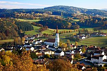
Zell is a municipality in the Upper Palatinate district of Cham in the Falkensteiner Vorwald and a member of the forest administration community .
Geographical location
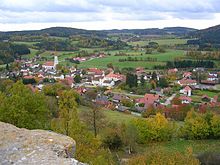
Zell is located in the Upper Bavarian Forest Nature Park and is a central place between Regensburg , Schwandorf , Cham and Straubing . The closest cities are Wörth an der Donau (23 kilometers southwest) and Roding (13 kilometers northeast). The Perlbach flows through the community area . The Lobenstein castle ruins are located nearby .
history
The name Zell is derived from a monastic foundation. The parish was first mentioned in 1326. When the Duchy of Bavaria was divided into a Bavarian and a Palatinate line, the town was also divided into a Bavarian Unterzell and a Palatinate Oberzell. The residents of Oberzell adopted the Protestant faith during the Reformation. After the annexation of the Electoral Palatinate possessions by the Duchy of Bavaria, the Oberzeller had to return to the Roman Catholic doctrine.
The district of Hetzenbach also has a long history. In 1249 the place Huzinbach was mentioned for the first time in the cadastre of the Walderbach monastery. Because of its location on the border between the county of Falkenstein and the Upper Palatinate, one of the most important trade routes to Regensburg, an inn was probably built at this location.
Incorporations
In 1945 or 1946, the previously independent municipality of Oberzell was incorporated into the municipality of Unterzell. In addition, parts of the dissolved municipality of Buchendorf were added. Beucherling and Schillertswiesen followed on July 1, 1971.
Name change
Since July 1, 1983, the municipality is officially called Zell.
Population development
Between 1988 and 2018 the municipality grew from 1,570 to 1,808 by 238 inhabitants or by 15.2%.
religion
At the beginning of 2011 97.9% of the population of Zell was Catholic, 1.4% Protestant and 0.2% belonged to another or no religious community.
Roman Catholic Church
The Catholics belong to the parish community of Wald Zell, which is assigned to the diocese of Regensburg . In addition to the parish church of the Assumption of Mary in Zell, there are also the branch churches of St. Florian in Beucherling, St. Martin in Martinsneukirchen, as well as the branch and pilgrimage church of St. Leonhard in Hetzenbach.
Politics and administration
Community structure
Zell has 51 districts:
There are three districts in the municipality : Beucherling, Schillertswiesen and Zell.
Municipal council
The Zeller municipal council consists of 12 voluntary councilors and the honorary Mayor . The local parliament is a legislature elected by six years.
The 2014 and 2020 local elections produced the following results:
| Party / group | Share of votes
2020 |
Seats
2020 |
Share of votes in 2014 | Seats
2014 |
|---|---|---|---|---|
| CSU | 27.9% | 3 | 26.0% | 3 |
| Christian Free Voting Community | 15.6% | 2 | 17.4% | 2 |
| Free voters | 17.4% | 2 | 16.8% | 2 |
| Citizen List | 20.5% | 3 | 15.4% | 2 |
| Schillertswiesen Union List | 11.6% | 1 | 11.6% | 1 |
| Free community of voters community welfare | 7.0% | 1 | 8.1% | 1 |
| Boy list | - | - | 4.7% | 1 |
mayor
The first mayor has been Thomas Schwarzfischer (CSU) since May 1, 2014; he was elected on March 15, 2020 with 96.6% of the valid votes for a further six years.
The second mayor is Gerhard Kerscher (citizen list), the third mayor is Eduard Fichtl (Schillertswiesen Union list).
coat of arms
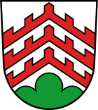
The heraldic description of the municipal coat of arms, introduced in 1983, reads: "In silver over a green Dreiberg, three top-tinned rafters on top of each other." The municipality of Zell is located east of Regensburg in a basin enclosed by the Mantelberg, the Geißberg and the Zellmüller Berg. As an indication of this characteristic geographical location, the municipal coat of arms shows a mountain of three. In the 14th century, the Hofer von Lobenstein built the Lobenstein Castle, which was then destroyed during the Thirty Years War and the ruins of which still remind us today of the importance of this family for the development of the municipality. Therefore, the three red rafters from the family coat of arms of the Hofer von Lobenstein family were incorporated into the municipal coat of arms.
Culture and sights
Buildings
There are a large number of architectural monuments in Zell.
Churches
- Parish church Maria Himmelfahrt Zell
- Baroque church of St. Martin Martinsneukirchen
- St. Florian Beucherling Church
- Pilgrimage Church of St. Leonhard Hetzenbach, built from 1762 to 1764 on a granite rock in the Rococo style.
Castles
Lobenstein castle ruins : The castle was built around 1340 by Eberhard the Hofer , whose noble family then called themselves the Hofer von Lobenstein . In 1629 the castle was occupied by Bavaria when the Lutheran Hofer had toleavethe Upper Palatinate after the re-Catholicization. It was destroyed during the Thirty Years War in 1633 and has been in ruins ever since. The castle consisted of a free-standing residential tower, another residential building, which has now been abandoned, and a circular wall that has also not been preserved.
In the vicinity
Supraregional hiking trails
Zell is located on the Goldsteig hiking trail. This runs from Zell over the rock park near Falkenstein and continues to the Tannerl and then over the Höllbachtal , Stallwang and Konzell to Sankt Englmar .
Sights
The Helferstein (natural monument) is also worth seeing.
Geotopes near Zell
Sports and clubs
There is a rich club life in the community. The volunteer fire brigade Zell and the fire brigades in the districts provide fire protection and general help in the municipality and beyond.
leisure
There are designated hiking and biking trails in the municipality, and cross-country skiing trails in winter. Carriage rides are also offered. There is the possibility of fishing, swimming, beach volleyball and sports shooting.
Cycle path
On the railway line from Regensburg to Falkenstein , which was closed in 1984 , a cycle path of approx. 40 km in length was established. You will find "Radler-Cafes" along the former railway line. There are connections to national cycle paths, the most important of which are the Regentalwanderweg, Danube cycle path , and festival cycle path .
Economy and Infrastructure
Zell has developed into a residential community through designated building areas in many places. There is a newly created industrial park available for business settlements. Zell has a well-developed infrastructure and numerous craft, service and trading companies. In 2017 there were 137 jobs subject to social security contributions in the municipality. Of the resident population, 826 people were in employment subject to compulsory insurance. This means that the number of out-commuters was 689 more than that of in-commuters. In 2016 there were 41 farms.
Important goals of the community are currently investments in renewable, environmentally friendly energy, energy-saving technology, the further development of the infrastructure and broadband supply.
Regular events
Every year at Whitsun, the traditional Whitsun festival takes place in Hetzenbach. The origin of the festival in its present form lies in the pilgrimages to the St. Leonhardt Church. A market around the church with numerous showmen is well known throughout the region.
tourism
Tourism is mainly geared towards farm holidays . There are also plenty of restaurants and private pensions.
Working group of the Upper Bavarian Forest
On January 8, 2007, the working group for the Vorderer Bayerischer Wald, or “AG Vorwald” for short, was founded. The aim of the working group is to promote and strengthen the region in terms of tourism, economy and culture. Members of this community are the communities of Altenthann , Bernhardswald , Brennberg , Falkenstein, Michelsneukirchen , Rettenbach , Wald , Wiesenfelden , Zell (Upper Palatinate) and the city of Wörth an der Donau , as well as all the local, tourism and tourist associations in these communities.
Public facilities
The following municipal facilities exist in Zell:
- Kindergarten with crèche; On March 1, 2018, she had a total of 57 places and looked after 74 children, 11 of them under the age of three and
- Community library.
education and Science
- Elementary school Zell with four teachers and 49 students (school year 2018/19)
- VHS courses
There is a school association with the community of Wald.
media
The Bayerwaldecho and a local edition of the Mittelbayerische Zeitung appear in the community .
Personalities
- Johann Nepomuk von Fuchs , chemist and mineralogist, was born on May 15, 1774 in the Mattenzell district.
Individual evidence
- ↑ "Data 2" sheet, Statistical Report A1200C 202041 Population of the municipalities, districts and administrative districts 1st quarter 2020 (population based on the 2011 census) ( help ).
- ↑ History of Zell on the parish homepage , accessed on August 26, 2020
- ^ Wilhelm Volkert (ed.): Handbook of Bavarian offices, communities and courts 1799–1980 . CH Beck, Munich 1983, ISBN 3-406-09669-7 , p. 560 .
- ^ Bavarian State Office for Statistics. Zell municipality. Municipal statistics 2015 ( Memento of the original from January 14, 2017 in the Internet Archive ) Info: The archive link was inserted automatically and has not yet been checked. Please check the original and archive link according to the instructions and then remove this notice. PDF, Munich 2016, p. 6.
- ^ Municipality of Zell in the local database of the Bavarian State Library Online . Bavarian State Library, accessed on August 26, 2020.
- ↑ Results. Retrieved March 25, 2020 .
- ↑ Deputy Mayor , accessed on August 26, 2020
- ^ Arbeitsgemeinschaft Vorderer Bayerischer Wald [1] , accessed on December 26, 2014.
- ↑ Zell elementary school in the school database of the Bavarian State Ministry for Education and Culture , accessed on August 26, 2020.
Web links
- Entry on the coat of arms of Zell (Upper Palatinate) in the database of the House of Bavarian History


