
Arnschwang
| coat of arms | Germany map | |
|---|---|---|

|
Coordinates: 49 ° 16 ' N , 12 ° 49' E |
|
| Basic data | ||
| State : | Bavaria | |
| Administrative region : | Upper Palatinate | |
| County : | Cham | |
| Height : | 390 m above sea level NHN | |
| Area : | 28.32 km 2 | |
| Residents: | 1998 (Dec. 31, 2019) | |
| Population density : | 71 inhabitants per km 2 | |
| Postcodes : | 93473, 93437 | |
| Area code : | 09977 | |
| License plate : | CHA, KÖZ, ROD , WÜM | |
| Community key : | 09 3 72 112 | |
| LOCODE : | DE 6AV | |
| Community structure: | 24 districts | |
| Address of the municipal administration: |
Kirchgasse 10 93473 Arnschwang |
|
| Website : | ||
| First Mayor : | Michael Multerer (Arnschwang Citizens' Block) | |
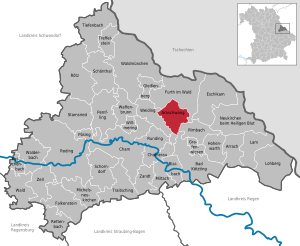
| Location of the municipality of Arnschwang in the Cham district | ||
  |
||

Arnschwang is a municipality in the Upper Palatinate district of Cham . The region around Arnschwang is part of the Upper Bavarian Forest Nature Park and offers a number of tourist attractions. In recent years, the community has developed into a focus on the generation of environmentally friendly energy from biomass and water.
geography
Geographical location
The place is at the transition from the Bavarian Forest to the Bohemian Forest about twelve kilometers northeast of the district town of Cham in the valley of the Chamb river .
Community structure
Arnschwang has 24 districts:
|
There are three districts in the municipality : Arnschwang, Nößwartling and Zenching. When the municipalities of Nößwartling and Zenching were dissolved (on July 1, 1972), their municipal area was also divided: Nößwartling to Arnschwang and Weiding and Zenching to Arnschwang and Rimbach .
history
Early history
As the earliest inhabitants of the area around Arnschwang, the Celts left visible traces in the first century BC. In the so-called Burgholz in the direction of Zenching there is a well-preserved Celtic Viereckschanze , which, in addition to cultic purposes, probably also served as a central meeting or court location for the village communities in the area.
The town of Arnschwang - like the Chamb river - derives its name from the language of these first detectable inhabitants: "wang" means flat field, meadow. This ending is preceded by the personal name "Aruni". Cattle pastures in the nearby Chambtal gave Arnschwang its name. The “Aruni pastureland”, “Aruni-wang” became “Arinswanch”, then Ornswanch and finally “Arnschwang” in the course of the 14th century.
Creation of the parish
Just a few decades after the monastery in Chammünster was established , a church could also have been founded in Arnschwang in 795. The extraordinary size of the parish district and the rare Martins patronage of the parish church in Upper Palatinate are indications of such an early date of foundation. The parish would be the oldest daughter of the early church Chammünster.
The town of Furth im Wald was separated from the Arnschwanger parish in 1585 and Dalking in 1697.
Castle and village in the Middle Ages
The first documentary mention of Arnschwang took place in 1173. At that time, a servant of the Chamer Margrave named himself after the place.

During this time, the two poles of the settlement, which are still clearly recognizable in the village structure, emerged: the church with an impressive fortification at the highest point of the old village, and the moated castle with farmyard and mill located below on Chamb .
After the “Arnschwanger” family, the Kälbl family followed in the 14th century, later the Püdensdorfer and the Sattelbogen family .
From 1426 the area was attacked and sacked several times by invading Hussites. When Emperor Heinrich was defeated with a large army in Bohemia in 1431, only the Arnschwang knight Erasmus Sattelbogen was able to bring his armed force back home. The folk piece, which is performed every year on the Further Drachenstich , ties in with this event during the Hussite Wars .
In 1489, the Arnschwanger castle lord Sigmund von Sattelbogen rebelled with several other knights in the so-called "Lion War" against the Baier duke. Arnschwang was then looted and the castle destroyed.
Between 1527 and 1612 which was Hofmark Arnschwang owned by the Frankish family Fuchs Wallburg .
During the Thirty Years War , Swedish troops raided and pillaged the village twice. After the first incursion in 1633, the plague hit Arnschwang a few weeks later and killed more than 280 people. In their distress, the people from Arnschwang took the vow to make a pilgrimage to the Mother of God in Weißenregen near Kötzting every year . This tradition has been preserved up to the present day.

The Hofmark in the early modern period
In 1722 Alois Bonaventura, Count von Kreuth, took over the Arnschwang Hofmark. During this time, the stately loft above the sacristy , which can still be admired in the parish church, was built .
In 1801 Baron von Völderndorff acquired the Arnschwang estate. He started to build a sugar factory here, tried making glass and finally boiling vinegar.
In 1826 the Bavarian state took over the property and then sold the property to various private individuals.
Village fire in 1858
On Michaelmas Day (September 29th) in 1858, almost the entire village was destroyed by a huge fire. The school house, the rectory and 41 residential buildings with 142 farm buildings burned down, 240 people were made homeless. The village was rebuilt with the help of a nationwide collection.
The modern church
In the course of the municipal reform on July 1, 1972, most of the municipalities of Zenching and Nößwartling were incorporated into Arnschwang. After bitter resistance from the citizens of Arnschwang, the municipality's membership of the administrative community Weiding , which was decreed in 1978, was withdrawn after more than seven years. Since January 1, 1986, Arnschwang has been a unified municipality with its own administration. In 2011 Arnschwang was named the most beautiful village in the Upper Palatinate by the jury of “Our village should be more beautiful - our village has a future”.
Population development
Between 1988 and 2018 the municipality grew from 1,795 to 2,009 by 214 inhabitants or by 11.9%.
coat of arms
Blazon : Growing in blue from a lowered silver wavy bar, the golden nimbly Saint Martin with red robe and silver cloak, who divides the cloak with the blue sword, top left with a little shield divided by gold, red and silver. The coat of arms was approved on April 19, 1984 by the government of the Upper Palatinate.
The community is located on the Chamb (wave bar) in the Further Senke and has a very old Martinskirche. The church patron St. Martin was therefore placed in the center of the coat of arms. His sword is also said to have a symbolic meaning, as the community area was often affected by war events. The village suffered a lot, especially during the Hussite Wars (1419–1433). The owner of Hofmark Arnschwang at the time, Erasmus Sattelboger, made a name for himself through his heroic fight against the Hussites . The family coat of arms of the Sattelboger, which died out in the 15th century (divided by gold, red, silver) was therefore also included in the coat of arms. The affiliation to the territory of the Wittelsbacher is underlined by the tinging silver and blue.
traffic
Street
The route of the federal road 20 runs through the municipality and leads from Cham to Furth im Wald and on to the German- Czech border.
railroad
Arnschwang has a train station on the Cham-Furth railway line in the forest . It is served almost every hour in both directions by regional railways of the Upper Palatinate Railway.
Air traffic
The small airfield Arnschwang is located near the village at the coordinates N49 16 19.2 and E12 46 48.0.
Attractions

Churches
Parish Church of St. Martin
The townscape of Arnschwang is characterized by the baroque parish church of St. Martin.
The choir in its outer walls as well as the substructure of the tower are of Gothic origin. Rebuilt in 1723. In 1899 the nave was raised, extended and extended by two yokes.

Church of St. Aegidius
In the district of Zenching there is the St. Agidius Expositur from the 18th century . 1730 rebuilding of the church using existing wall parts. 1845 Extension by two side chapels. 1939 Demolition of the nave and new construction of the nave.

Dance of death
In the soul chapel in Zenching is the only dance of death representation in the eastern Upper Palatinate. Here death is shown in eight pictures. It was probably renewed around 1760 by the painter Martin Josef Hueber von Kötzting and in 1910 by the painter Schmalzl from Falkenstein, modernizing its shape and style.
Patrona Bavariae made of glass
On the glass gable end of the chapel in Tretting you can see the portrayal of Patrona Bavariae as a patron saint. It was created in 2002 by the glass artist Bernhard Schagemann using the technique of "lost forms". The chapel has a modern interior and a way of the cross with 14 relief panels made of unglazed ceramic by the sculptor Veronika Schagemann from the same year.


LBV Center Man and Nature
In the district of Nößwartling, the LBV Center for People and Nature can be visited in the "Alte Mühle" . The "old mill" has been owned by the municipality of Arnschwang since 1991. The wire island, which is directly adjacent to the LBV center, was leased by the LBV in 1979 and maintained and designed as a habitat for rare flora and especially fauna through the creation and optimization of biotopes.
Architectural monuments
Soil monuments
- Near the district of Zenching there is a Celtic square hill from pre-Christian times.
- The so-called "Schwedenschanzen" in Ponnholz are early medieval and were laid out in the forest to protect the old elevated road between Cham and Furth.
- Old mine tunnels for the extraction of lime can still be seen in the area in the Kalkofen district.
Underground tunnels
In Arnschwang there were numerous earth stables (underground passages), so-called "Schrazellöcher".

Labyrinth fountain
The labyrinth fountain is a village fountain created by the local sculptor Toni Scheubeck in 1995 on the occasion of the 1200th anniversary. The water channels are cut from Fürstenstein granite, which makes them appear lighter. The remaining surfaces are shaded. The source and mouth of the watercourse in the fountain are marked with the years 795 and 1995.

Moated castle
The Arnschwang moated castle is located between two arms of the Chamb River in the eastern part of the village. Today it is a two-story, elongated building. On its facade there are remains of architectural paintings as window frames. Only the west wing and part of the moat have survived from the originally irregular three-wing complex. The ground floor with parts of the upper floor still belong to the structure of the 14/15. Century. In the following construction phases, numerous changes were made to the building. One floor was demolished at the beginning of the 20th century. The building has been completely renovated since 2010.

Web links
- Entry on the coat of arms of Arnschwang in the database of the House of Bavarian History
- Arnschwang municipality
- History of the parish of Arnschwang
- Family tables of the parish of Arnschwang
- Arnschwang: Official statistics of the LfStat
Individual evidence
- ↑ "Data 2" sheet, Statistical Report A1200C 202041 Population of the municipalities, districts and administrative districts 1st quarter 2020 (population based on the 2011 census) ( help ).
- ^ District Cham : Mayor elections 2020. Arnschwang. Retrieved May 16, 2020 .
- ^ Municipality of Arnschwang in the local database of the Bavarian State Library Online . Bayerische Staatsbibliothek, accessed on January 3, 2018.
- ↑ Alois Schmid: The Viereckschanze of Nößwartling. In: Festschrift and village chronicle of the villages of Nößwartling and Grasfilzing. Voluntary fire department Nößwartling 1998, pp. 58–61.
- ↑ Werner Perlinger : Arnschwang in early times. In: Church and Community of Arnschwang. 1995, pp. 44-45.
- ↑ Wolf-Armin Frhr. v. Reitzenstein : Lexicon of Bavarian place names. Origin and meaning . CH Beck, Munich 2006, ISBN 3-406-55206-4 , p. 20-21 .
- ^ Paul Mai: 1200 years of the parish of Arnschwang. In: Church and Community of Arnschwang. 1995, p. 23.
- ↑ Max Heitzer: Arnschwang: location for a Carolingian royal church. In: Church and Community of Arnschwang. 1995, pp. 32-35.
- ^ Max Heitzer: The parish of Arnschwang. In: Church and Community of Arnschwang. 1995, pp. 123-124.
- ↑ a b Max Piendl: Cham district court. In: Historical Atlas of Bavaria. Vol. 8, 1955, p. 33.
- ↑ Werner Perlinger: Arnschwang in the 15th century - a stormy epoch. In: Church and Community of Arnschwang. 1995, pp. 59-60.
- ↑ Werner Perlinger: Arnschwang in the 15th century - a stormy epoch. In: Church and Community of Arnschwang. 1995, p. 64.
- ↑ a b c d Max Piendl: Cham district court. In: Historical Atlas of Bavaria. Vol. 8, 1955, p. 34.
- ↑ Alois Heitzer: The great Arnschwanger village fire on Michaelmas 1858. In: Historischer Verein Furth i. W. and surroundings. Yearbook 7, 1996, pp. 171-193.
- ^ Wilhelm Volkert (ed.): Handbook of Bavarian offices, communities and courts 1799–1980 . CH Beck, Munich 1983, ISBN 3-406-09669-7 , p. 440 .
- ↑ Second law on changing the membership of municipalities in administrative communities of 23 July 1985, GVBl p. 270
- ↑ http://www.mittelbayerische.de/index.cfm?pid=10041&pk=718852&p=1
- ^ Heinrich Blab: From the Hofmark to the modern community. In: Church and Community of Arnschwang. 1995, p. 233.
- ↑ Rich. Hoffmann and Gg. Hager: Cham district office. In: The art monuments of Upper Palatinate and Regensburg. Vol VI, 1906, p. 13.
- ↑ Joseph Maria Ritz: District Office Kötzting. In: The art monuments of Lower Bavaria. Volume IX, 1922, p. 119.
- ^ Pastor Lang: The dance of death in Zenching. In: 75 Years of Warriors and Soldier Comradeship Zenching. 2001, pp. 75-76.
- ↑ Patrona Bavariae in Tretting, commemorative publication on the occasion of the inauguration of the chapel. 2002, pp. 4-16.
- ↑ Heribert Mühlbauer: The LBV center for people and nature. In: Festschrift and village chronicle of the villages of Nößwartling and Grasfilzing. Voluntary Fire Brigade Nößwartling 1998, p. 116.
- ↑ Toni Scheubeck: Fountain Village Square Arnschwang. In: Church and Community of Arnschwang. 1995, pp. 510-511.
- ↑ Bernhard Ernst: Building castles in the south-eastern Upper Palatinate from the early Middle Ages to the early modern period, Part II. In: Works on the archeology of southern Germany, Vol. 16, 2003, pp. 22-23.

Arnschwang | Arrach | Bad Kötzting | Blaibach | Cham | Chamerau | Eschlkam | Falkenstein | Furth in the forest | Gleißenberg | Grafenwiesen | Hohenwarth | Lam | Lohberg | Michelsneukirchen | Miltach | Neukirchen near the Holy Blood | Pemfling | Pösing | Reichenbach | Rettenbach | Rimbach | Roding | Rötz | Rounding | Schönthal | Schorndorf | Stamsried | Tiefenbach | Traitsching | Treffelstein | Weapon Well | Forest | Walderbach | Waldmünchen | Weiding | Willmering | Zandt | Cell
Arnschwang | Berghäusl | Blumhof | Dürnberg | Eichmühle | Elst | Enklarn | Faustendorf | Grass felting | Herrenwies | Holzhof | Lime kiln | Kellerweg | Kuglhof | Lederhof | Lindhof | Mühlberg | Nößwartling | Rumplmühle | Traditional house | Tretting | Warming | Weihermühle | Zenching