
Administrative community Kallmünz
| coat of arms | Germany map | |
|---|---|---|
 Help on coat of arms |
Coordinates: 49 ° 10 ′ N , 11 ° 58 ′ E |
|
| Basic data | ||
| State : | Bavaria | |
| Administrative region : | Upper Palatinate | |
| County : | regensburg | |
| Area : | 81.71 km 2 | |
| Residents: | 5344 (Dec. 31, 2019) | |
| Population density : | 65 inhabitants per km 2 | |
| License plate : | R. | |
| Association key : | 09 3 75 5332 | |
| Association structure: | 3 municipalities | |
| Association administration address : |
Keltenweg 1 93183 Kallmünz |
|
| Website : | ||
| Chairman : | Siegfried Bauer | |
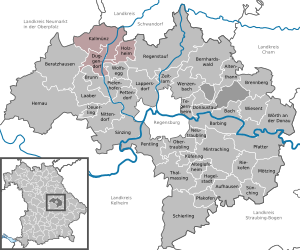
| Location of the Kallmünz administrative community in the Regensburg district | ||
  |
||

The administrative community Kallmünz is located in the Upper Palatinate district of Regensburg and is formed by the following communities:
- Duggendorf , population 1577, 22.88 km²
- Holzheim a.Forst , 968 inhabitants, 15.64 km²
- Kallmünz , market , population 2799, 43.19 km²
The administrative association is based in Kallmünz.
Siegfried Bauer is the joint chairman.
Individual evidence
- ↑ "Data 2" sheet, Statistical Report A1200C 202041 Population of the municipalities, districts and administrative districts 1st quarter 2020 (population based on the 2011 census) ( help ).
Administrative communities in the Regensburg district