
Administrative community Laaber
| coat of arms | Germany map | |
|---|---|---|
 Help on coat of arms |
Coordinates: 49 ° 4 ' N , 11 ° 53' E |
|
| Basic data | ||
| State : | Bavaria | |
| Administrative region : | Upper Palatinate | |
| County : | regensburg | |
| Area : | 52.91 km 2 | |
| Residents: | 8713 (Dec. 31, 2019) | |
| Population density : | 165 inhabitants per km 2 | |
| License plate : | R. | |
| Association key : | 09 3 75 5333 | |
| Association structure: | 3 municipalities | |
| Association administration address : |
Jakobstrasse 9 93164 Laaber |
|
| Website : | ||
| Chairman : | Hans Schmid ( CSU ) | |
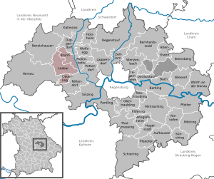
| Location of the Laaber administrative community in the Regensburg district | ||
  |
||

The Laaber administrative community is located in the Upper Palatinate district of Regensburg and is formed by the following communities:
- Brunn , 1426 inhabitants, 16.12 km²
- Deuerling , 2001 inhabitants, 7.13 km²
- Laaber , market , 5286 inhabitants, 29.66 km²
The administrative community is based in Laaber. The joint chairman is Hans Schmid (CSU).
Individual evidence
- ↑ "Data 2" sheet, Statistical Report A1200C 202041 Population of the municipalities, districts and administrative districts 1st quarter 2020 (population based on the 2011 census) ( help ).
Administrative communities in the Regensburg district