
Schwarzach near Nabburg
| coat of arms | Germany map | |
|---|---|---|

|
Coordinates: 49 ° 25 ' N , 12 ° 14' E |
|
| Basic data | ||
| State : | Bavaria | |
| Administrative region : | Upper Palatinate | |
| County : | Schwandorf | |
| Management Community : | Schwarzenfeld | |
| Height : | 386 m above sea level NHN | |
| Area : | 27.35 km 2 | |
| Residents: | 1423 (Dec. 31, 2019) | |
| Population density : | 52 inhabitants per km 2 | |
| Postal code : | 92548 | |
| Area code : | 09675 | |
| License plate : | SAD, BUL , NAB , NEN, OVI, ROD | |
| Community key : | 09 3 76 162 | |
| Community structure: | 15 districts | |
| Association administration address: | Viktor-Koch-Str. 4 92521 Schwarzenfeld |
|
| Website : | ||
| Mayor : | Hans Gradl | |
| Location of the community of Schwarzach near Nabburg in the Schwandorf district | ||
  |
||


Schwarzach bei Nabburg (officially Schwarzach b.Nabburg ) is a municipality in the Upper Palatinate district of Schwandorf and a member of the Schwarzenfeld administrative community .
geography
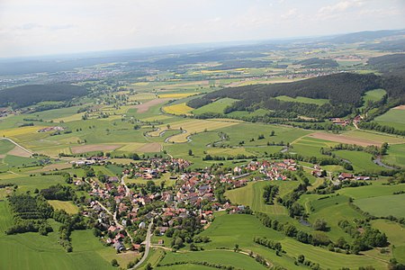
The community is located in the Upper Palatinate North region on the Schwarzach River , which flows into the Naab near Schwarzenfeld .
Community structure
Schwarzach bei Nabburg consists of the following 15 parts of the municipality:
history
Until the church is planted
The community part Wölsendorf was first mentioned in 1015. Schwarzach belonged to the Amberg Rent Office and the Nabburg Regional Court of the Electorate of Bavaria . In the course of the administrative reforms in Bavaria , the municipality was created with the municipal edict of 1818 .
Incorporations
Parts of the municipality of Unterauerbach, which was dissolved on January 1, 1974, came to Schwarzach on January 1, 1974. On January 1, 1975, the previously independent community of Altfalter, which had been expanded to include Weiding on January 1, 1971, was incorporated.
Population development
Between 1988 and 2018, the municipality grew from 1,397 to 1,445 by 48 inhabitants or 3.4%.
- 1961: 1325 inhabitants
- 1970: 1360 inhabitants
- 1987: 1372 inhabitants
- 1991: 1459 inhabitants
- 1995: 1468 inhabitants
- 2000: 1486 inhabitants
- 2005: 1552 inhabitants
- 2010: 1521 inhabitants
- 2015: 1449 inhabitants
politics
mayor
The long-time mayor Alois Böhm died on August 22, 2016. Until the new election (runoff) on December 18, 2016, the second mayor, Franz Grabinger, was in charge of the official business.
In the new mayor election, Hans Gradl (Free Voting Association Altfalter-Weiding-Richt) from the Altfalter district prevailed against Hubert Jetschmann (FWG Schwarzach) with 58.7%.
coat of arms
Coat of arms since 1987. Blazon : In silver, a black wavy bar , above a blue plow , underneath between two blue stars standing one above the other a blue miner's lamp .
Architectural monuments
nature
Economy and Infrastructure
Economy including agriculture and forestry
In 1998 there were no employees subject to social insurance contributions at the place of work according to official statistics in the manufacturing sector 121 and in the trade and transport sector. There were a total of 523 employees at the place of residence subject to social security contributions. There were none in the manufacturing sector and three in the construction sector. In addition, in 1999 there were 67 farms with an agricultural area of 1443 hectares, 908 hectares of which were arable land.
education
There are no kindergartens or schools in town.
Others
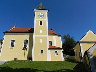
Ancestors of the composer Max Reger are buried in the cemetery in Schwarzach .
Altmalter with Schwarzach (2013)
Ortisei (2011)

The Schwarzach (2011)

Wölsendorf (2011)


.jpg)

Individual evidence
- ↑ "Data 2" sheet, Statistical Report A1200C 202041 Population of the municipalities, districts and administrative districts 1st quarter 2020 (population based on the 2011 census) ( help ).
- ^ Community Schwarzach near Nabburg in the local database of the Bavarian State Library Online . Bayerische Staatsbibliothek, accessed on December 20, 2017.
- ^ Wilhelm Volkert (ed.): Handbook of Bavarian offices, communities and courts 1799–1980 . CH Beck, Munich 1983, ISBN 3-406-09669-7 , p. 529 .
- ^ Federal Statistical Office (ed.): Historical municipality directory for the Federal Republic of Germany. Name, border and key number changes in municipalities, counties and administrative districts from May 27, 1970 to December 31, 1982 . W. Kohlhammer GmbH, Stuttgart / Mainz 1983, ISBN 3-17-003263-1 , p. 667 .
Web links
- Aerial photos of the place
- Entry on the coat of arms of Schwarzach near Nabburg in the database of the House of Bavarian History

Altendorf | Bodenwohr | Bruck in the Upper Palatinate | Burglengenfeld | Dieterskirchen | Fensterbach | Slip | Guteneck | Maxhütte-Haidhof | Nabburg | Neukirchen-Balbini | Neunburg vorm Wald | Niedermurach | Nittenau | Oberviechtach | Pfreimd | Schmidgaden | Schönsee | Schwandorf | Schwarzach near Nabburg | Schwarzenfeld | Schwarzhofen | Stadlern | Steinberg am See | Stulln | Teublitz | Teunz | Thanstein | Trausnitz | Wackersdorf | Weiding | Wernberg-Koeblitz | Winklarn
Unregulated areas: Wolferlohe
Old butterfly | Auhof | Dietstätt | Furthmühle | Oberwarnbach | Wasteland | Wasteland | Dir | Sattelhof | Schwarzach near Nabburg | Sindelsberg | Unterauerbach | Unterwarnbach | Weiding | Wölsendorf