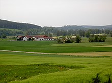
Auhof (Schwarzach near Nabburg)
|
Auhof
Municipality Schwarzach bei Nabburg
Coordinates: 49 ° 23 ′ 29 ″ N , 12 ° 11 ′ 30 ″ E
|
||
|---|---|---|
| Height : | 365 m | |
| Postal code : | 92548 | |
| Area code : | 09439 | |
|
Location of Auhof in Bavaria |
||
Auhof is a district of the municipality of Schwarzach bei Nabburg in the Upper Palatinate district of Schwandorf ( Bavaria ).
Geographical location
Auhof is located about four kilometers southwest of Schwarzach. It is located in the Schwarzachtal about 200 meters north of the state road 2159 .
history
In 1808 Auhof was listed with an estate. In accordance with an ordinance of 1808, the Nabburg Regional Court was divided into 58 tax districts. Altfalter formed a tax district with the hamlet of Richt and the desert areas of Furthmühle and Auhof. As a further step in the formation of political communities, chairmen were established around 1811 , including the chairmanship of Wölsendorf, to which Wölsendorf, Altfalter, Weiding, Warnbach, Dietstätt, Sindelsberg, Richt, Auhof and Sattelhof belonged.
In 1820 rural communities were formed. This resulted in the rural community Altfalter, which consisted of the village of Altfalter with 42 families, the hamlet of Furthmühle with 3 families and the desert Auhof with one family.
Altfalter has been a rural community since 1828. In 1828 Auhof had a residential building, a family and five residents.
In 1975 Altfalter was incorporated into the community of Schwarzach near Nabburg. Auhof thus came to the community of Schwarzach near Nabburg.
Population development in Auhof from 1838
| year | Residents | building |
|---|---|---|
| 1838 | 11 | 1 |
| 1875 | 8th | 4th |
| 1885 | 0 | 1 |
| 1900 | 9 | 1 |
| 1913 | 9 | 1 |
| 1925 | 7th | 1 |
| year | Residents | building |
|---|---|---|
| 1950 | 5 | 1 |
| 1961 | 5 | 1 |
| 1970 | 7th | k. A. |
| 1987 | 3 | 1 |
| 2011 | 5 | k. A. |
literature
- Elisabeth Müller-Luckner, Historical Atlas of Bavaria, part of Old Bavaria, issue 50, Nabburg, Munich 1981, ISBN 3-7696-9915-7
Individual evidence
- ^ Elisabeth Müller-Luckner, Historical Atlas of Bavaria, part of Altbayern, No. 50, Nabburg, Munich 1981, ISBN 3-7696-9915-7 , p. 344
- ^ Elisabeth Müller-Luckner, Historical Atlas of Bavaria, part of Altbayern, No. 50, Nabburg, Munich 1981, ISBN 3-7696-9915-7 , p. 397
- ^ Elisabeth Müller-Luckner, Historical Atlas of Bavaria, part of Altbayern, No. 50, Nabburg, Munich 1981, ISBN 3-7696-9915-7 , p. 407
- ^ Elisabeth Müller-Luckner, Historical Atlas of Bavaria, part of Altbayern, No. 50, Nabburg, Munich 1981, ISBN 3-7696-9915-7 , p. 415
- ^ Elisabeth Müller-Luckner, Historical Atlas of Bavaria, part of Altbayern, No. 50, Nabburg, Munich 1981, ISBN 3-7696-9915-7 , p. 417
- ^ Elisabeth Müller-Luckner, Historical Atlas of Bavaria, part of Altbayern, issue 50, Nabburg, Munich 1981, ISBN 3-7696-9915-7 , p. 438
- ↑ https://www.bayerische-landesbibliothek-online.de/landesbeschreibung-orte
- ↑ Josepf Lipf (Editor): matrikel bishopric of Regensburg . Ed .: Diocese of Regensburg. Pustet, Regensburg 1838, p. 187 ( digitized version ).
- ↑ Kgl. Statistical Bureau (ed.): Complete list of localities of the Kingdom of Bavaria. According to districts, administrative districts, court districts and municipalities, including parish, school and post office affiliation ... with an alphabetical general register containing the population according to the results of the census of December 1, 1875 . Adolf Ackermann, Munich 1877, 2nd section (population figures from 1871, cattle figures from 1873), Sp. 875 , urn : nbn: de: bvb: 12-bsb00052489-4 ( digitized ).
- ↑ K. Bayer. Statistical Bureau (Ed.): Localities directory of the Kingdom of Bavaria. According to government districts, administrative districts, ... then with an alphabetical register of locations, including the property and the responsible administrative district for each location. LIV. Issue of the contributions to the statistics of the Kingdom of Bavaria. Munich 1888, Section III, Sp. 823 ( digitized version ).
- ↑ K. Bayer. Statistical Bureau (Ed.): Directory of localities of the Kingdom of Bavaria, with alphabetical register of places . LXV. Issue of the contributions to the statistics of the Kingdom of Bavaria. Munich 1904, Section II, Sp. 857 ( digitized version ).
- ^ Diocese of Regensburg (ed.): Register of the Diocese of Regensburg . ed. i. A. Sr Excellency of the Most Revered Bishop Dr. Antonius von Henle from the Episcopal Ordinariate Regensburg. Regensburg 1916, p. 358 ( digitized version ).
- ↑ Bavarian State Statistical Office (ed.): Localities directory for the Free State of Bavaria according to the census of June 16, 1925 and the territorial status of January 1, 1928 . Issue 109 of the articles on Bavaria's statistics. Munich 1928, Section II, Sp. 863 ( digitized version ).
- ↑ Bavarian State Statistical Office (ed.): Official place directory for Bavaria - edited on the basis of the census of September 13, 1950 . Issue 169 of the articles on Bavaria's statistics. Munich 1952, DNB 453660975 , Section II, Sp. 733 ( digitized version ).
- ↑ Bavarian State Statistical Office (ed.): Official city directory for Bavaria, territorial status on October 1, 1964 with statistical information from the 1961 census . Issue 260 of the articles on Bavaria's statistics. Munich 1964, DNB 453660959 , Section II, Sp. 541 ( digitized version ).
- ^ Bavarian State Statistical Office (ed.): Official place directory for Bavaria . Issue 335 of the articles on Bavaria's statistics. Munich 1973, DNB 740801384 , p. 138 ( digitized version ).
- ↑ Bavarian State Office for Statistics and Data Processing (Ed.): Official local directory for Bavaria, territorial status: May 25, 1987 . Issue 450 of the articles on Bavaria's statistics. Munich November 1991, DNB 94240937X , p. 279 ( digitized version ).
- ↑ http://atlas.zensus2011.de/


