
Schwarzach (Naab)
|
Schwarzach upper course: Bohemian Schwarzach , Czech: Nemanický potok |
||
 The Schwarzach flows into the Naab at Schwarzenfeld |
||
| Data | ||
| Water code | EN : 146 | |
| location | Czech Republic , Upper Palatinate | |
| River system | Danube | |
| Drain over | Naab → Danube → Black Sea | |
| source | east of Závist ( Rybník district ) 49 ° 29 ′ 28 ″ N , 12 ° 41 ′ 50 ″ E |
|
| Source height | approx. 660 m nm | |
| muzzle | near Schwarzenfeld in the Naab coordinates: 49 ° 23 '36 " N , 12 ° 9' 10" E 49 ° 23 '36 " N , 12 ° 9' 10" E |
|
| Mouth height | 360 m above sea level NN | |
| Height difference | approx. 300 m | |
| Bottom slope | approx. 3.2 ‰ | |
| length | 95 km with the Bohemian Schwarzach |
|
| Catchment area | 841.45 km² | |
| Discharge at the Warnbach A Eo gauge : 822 km² Location: 7.4 km above the mouth |
NNQ (08/09/1964) MNQ 1941–2006 MQ 1941–2006 Mq 1941–2006 MHQ 1941–2006 HHQ (07/09/1964) |
850 l / s 2.76 m³ / s 8.59 m³ / s 10.5 l / (s km²) 54.7 m³ / s 145 m³ / s |
| Reservoirs flowed through | Perlsee , Silbersee , Eixendorftalsperre | |
The Schwarzach is a left tributary of the Naab in the Czech Republic and Bavaria. It is around 95 km long with its left, north-eastern upper course. This is sometimes seen as an independent river under the name Böhmische Schwarzach (Czech: Nemanický potok ).
course
The Schwarzach rises in the Czech part of the Upper Palatinate Forest (Czech. Český les) east of the village of Závist (German Neid , municipality Rybník ) directly on the European main watershed ; Only a few hundred meters north of the source is the source of the Radbuza , which drains over the Vltava and Elbe to the North Sea. Flowing almost exactly south in the upper reaches, the Schwarzach crosses the border to Bavaria shortly after the place Nemanice (German water soup ), from which its Czech name Nemanický potok is derived, where it follows the main westward direction from Waldmünchen .
Other places on the Schwarzach are Schönthal , Rötz , Neunburg vorm Wald and Schwarzach near Nabburg . To the west of the mouth of the river Naab is the Schwarzenfeld market .
The "Swarza" was mentioned as early as 1250. Numerous mills, saws, hammers and, in the middle of the 18th century, glass grinding and polishing works were built on the Schwarzach. Around 1850 there were over 30 grinding and polishing works on the Schwarzach, whose decline began before the Second World War.
Sometimes the approximately 24 km long upper course of the Schwarzach, which rises in the Czech Republic, up to the confluence of the Bavarian Schwarzach is also called the Bohemian Schwarzach and sees it as an independent river. With this view, the Schwarzach would only arise from the confluence of the left Bohemian and right Bavarian Schwarzach near the Waldmünchner district Kritzenast .
Tributaries
From the confluence of the Bohemian and Bavarian Schwarzach to the mouth of the Schwarzach.
Tributaries of the Bohemian Schwarzach, some of which are part of the Schwarzach, see their article.
| Left tributaries | Right tributaries |
Flood regulation
The flow system goes through three reservoirs for flood control : the at Waldmünchen located Perlsee , the at Treffelstein located Silver (from the Bavarian Schwarzach is traversed, a tributary of the Schwarzach) and at Rötz located Eixendorfer reservoir . The Perlsee has an area of about 21 hectares at the permanent damming destination, the Silbersee about 55 hectares. The Schwarzach is dammed between Neunburg vorm Wald and Rötz for flood protection and electricity generation to (in normal congestion) about 100 hectares of the Eixendorfer See . Eixendorf, Wutzschleife, Höllmühle, Obermühle, Seebarnhammer and a section of the former Bodenwöhr – Rötz railway sank into this lake . The dam was put into operation in 1975.
Picture gallery

Confluence of the Bohemian (left) and Bavarian (right) Schwarzach to Schwarzach near Kritzenast
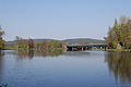
The Schwarzach flows into the Naab

The Schwarzach near Altfalter (2012)

Altendorf with the river Schwarzach (2011)

The Schwarzach near Schwarzhofen (2012)

River Schwarzach near Neunburg v. Forest

Eixendorftalsperre with dam


See also
Web links
- Map of the Schwarzachlauf on: BayernAtlas of the Bavarian State Government ( information )
- Map of the catchment area of the Schwarzach in Bavaria on: Map service water management, FGN Bavarian State Office for the Environment ( information )
Individual evidence
Water directory Bavaria ("GV")
- ↑ a b Length according to: Directory of creek and river areas in Bavaria - Naab river area of the Bavarian State Office for the Environment, as of 2016 (PDF; 4.0 MB)
- ↑ Catchment area according to: Directory of stream and river areas in Bavaria - Naab river area of the Bavarian State Office for the Environment, as of 2016 (PDF; 4.0 MB)
Others
- ↑ Bavaria Atlas of the Bavarian State Government ( notes )
- ^ German Hydrological Yearbook Danube Region 2006 Bavarian State Office for the Environment, p. 159, accessed on October 4, 2017, from: bestellen.bayern.de (PDF, German, 24.2 MB).
- ^ Bavarian State Office for the Environment, State Water Reservoir , Perlsee , accessed on July 23, 2015
- ^ Bavarian State Office for the Environment, State Water Reservoir, Silbersee , accessed on July 23, 2015
- ↑ Bavarian State Office for the Environment, State Water Reservoir, Eixendorfer See , accessed on July 23, 2015