
Bavarian Schwarzach
|
Bavarian Schwarzach Švarcava, Černice |
||
 |
||
| Data | ||
| Water code | CZ : 4-01-03-013, DE : 1462 | |
| location | Upper Palatinate , Czech Republic | |
| River system | Danube | |
| Drain over | Schwarzach (Naab) → Naab → Danube → Black Sea | |
| source | north of Stadlern - Waldhäuser 49 ° 31 ′ 9 ″ N , 12 ° 38 ′ 32 ″ E |
|
| Source height | 778 m above sea level NHN | |
| muzzle | shortly before Waldmünchen - Kritzenast from the right and approximately north into the Schwarzach Coordinates: 49 ° 22 ′ 34 ″ N , 12 ° 38 ′ 10 ″ E 49 ° 22 ′ 34 ″ N , 12 ° 38 ′ 10 ″ E |
|
| Mouth height | approx. 458 m above sea level NN | |
| Height difference | approx. 320 m | |
| Bottom slope | approx. 13 ‰ | |
| length | 24.5 km | |
| Catchment area | 86.03 km² | |
| Discharge at the Tiefenbach A Eo gauge : 57.7 km² Location: 9.4 km above the mouth |
NNQ (08/02/1963) MNQ 1959–2006 MQ 1959–2006 Mq 1959–2006 MHQ 1959–2006 HHQ (01/26/1995) |
100 l / s 263 l / s 727 l / s 12.6 l / (s km²) 10.6 m³ / s 37 m³ / s |
| Reservoirs flowed through | Silver lake | |
 Silbersee hydraulic structure, southern bathing area |
||
The Bavarian Schwarzach is the right and northern, almost 25 km long upper reaches of the Schwarzach in Bavaria and along the Czech border. Its left and north-north-eastern upper reaches of the Bohemian Schwarzach rises near Zavist in the Czech Republic, is almost the same length, but brings the Schwarzach noticeably more catchment area, which is why it is also considered its main upper course and is often referred to as the Schwarzach. Shortly before the Waldmünchner village Kritzenast both branches come together, the Schwarzach then flows sinuously southwards.
course
The Bavarian Schwarzach rises from the "Goldbrunnen" at 778 m above sea level. NHN on the eastern slope of the Eibenziegenberg about 1 km north of the small mountain village of Waldhäuser . It flows south along the Czech border and soon joins the Goldbach, which is fed by the same source. In this area springs were mostly referred to as "wells". On the Reichenstein massif, to which the Eibenziegenberg belongs, gold was found in the 16th century, hence the names "Goldbrunnen" and "Goldbach". The Bavarian Schwarzach flows right along the German-Czech border to the south.
Coming down from the eastern slope of the Häuslberg, the Mühlbach flows south of Waldhäuser from the right into the Bavarian Schwarzach. The Bavarian Schwarzach then flows between Schwarzach and the Švarcava desert . About one kilometer further south it passes the wasteland of Neumühle . It changes direction and flows to the southwest and east of Charlottenthal . At this point the Grenzbach (Czech: Šedi potok) flows into the Bavarian Schwarzach from the left.
From its source to this point, the course of the Bavarian Schwarzach coincided with the German-Czech border. Now, southeast of Charlottenthal, the Bavarian Schwarzach is leaving the border and entering Bavarian territory. It continues to flow in a south-westerly direction, past the individual houses in Lenkenthal to the Schusterbügel, which forces it to change direction sharply to the west. A narrow east-west-directed breakthrough valley follows, behind which the Bavarian Schwarzach resumes its predominant north-south direction.
South of Schönau , it takes in the Hüttenbach. About one kilometer further south, the Hammermühlbach splits off from the Bavarian Schwarzach at a weir. It supplies the power plant and the hammer mill's saw and reunites with the Bavarian Schwarzach. Shortly after this junction, the Markbach flows into the Hammermühlbach when coming from the northwest. To the southwest of Treffelstein , the Bavarian Schwarzach is dammed up to form the 1.5 km long Silbersee , which is used as a bathing lake. In Witzel mill Bayerische Schwarzach leaves the Silver Lake.
The Bavarian Schwarzach flows south along the western outskirts of Witzelsmühle, then east past Grubholz. Coming from the south-eastern slope of the Irlberg, the Steinerbach flows south past Stein and joins the Bavarian Schwarzach from the right at Grubholz. After the Bavarian Schwarzach has passed the Grubholz, it encounters the elevation of the Wullnbaurholz. It gives way to the east and breaks through after about a kilometer between Wullnbaurholz and Reiterholz to the south. To the northeast of Eschlhof, it takes up the Eschlbach coming from the right. The Bavarian Schwarzach smoothly crosses the swampy Stockwiese in a south-easterly direction and merges north of Kritzenast with the Bohemian Schwarzach to Schwarzach.
The catchment area of the Švarcava or Černice covers 12.162 km² on the 6.2 long section in the Czech Republic.
Tributaries
From the source to the confluence with the Bohemian Schwarzach. Selection.
- Goldbach , from the right and north south of Waldhäuser, 1.7 km and 1.1 km². It rises north of Waldhäuser on the southeast slope of the Weingartenfels.
- (Inflow before Stadlern - Schwarzach ), from the right and west, 1.3 km and 3.4 km².
- Mühlbach , from the right north of Schwarzach. It rises northwest of Schwarzach.
-
Grenzbach (Czech: Šedý potok), from the left and southeast below Neumühle and opposite the Stadlern- Charlottenthal on the right slope , 2.4 km and 2.4 km².
Here the Bavarian Schwarzach flows into Bavarian territory, the state border runs uphill along the Grenzbach-Lauf. - (Bach from the Schönau Forest ), from the right and northwest about 0.8 km south-southeast of Charlottenthal, 1.5 km and 1.2 km². It rises a little to the north-west of the village, but already runs entirely on the Schönau district of the Tiefenbach community .
- Hüttenbach , from the right and north south of Tiefenbach- Perlthal , 11.1 km with the upper course and 24.6 km². With the run from this to here almost equally weighted right branch of the Bavarian Schwarzach. Its top source is that of the Schnabellohbach on the southwest slope of the Weingartenfels .
- → Branch of the tributary Hammermühlbach, to the right at Tiefenbach- Krausenöd .
- Markbach , from the right and west-northwest into the just branched off Hammermühlbach, 5.7 km and 7.3 km². Originates from the Markbrunnen on the eastern slope of the Signalberg .
- ← Backflow of the Hammermühlbach, from the right at the Tiefenbacher Hammermühle , 1.4 km and 8.4 km².
- Tiefenbach , from the right shortly after the Hammermühle southeast of the parish village Tiefenbach itself, 4.9 km and 4.5 km². Rises from the cold well .
- (Bach through the Fahrenweiher ), from the right and west-northwest to Tiefenbach-Michelsthal, 2.9 km and 3.3 km².
- Runs through the Silver Lake , 55 ha.
- (Stream through the Tiefenbacher Bücherlmühle ), from the right and west-northwest in the Silbersee, 1.5 km and 1.7 km².
- Kressenbach , from the right and west northwest south below the Tiefenbacher Witzelsmühle , 3.9 km with the longer left upper course Steinerbach and 5.9 km². The Steinerbach arises near Tiefenbach- Irlach .
- (Inflow), from the left and north at the bridge of the district road CHA 54, 0.6 km and 0.3 km².
- (Tributary), from the left and northwest south of Treffelstein - Biberbach , 0.7 km and 0.5 km².
- Eschlbach , from the right and west northeast of Waldmünchen -Eschlhof, 2.8 km and 1.8 km²
Flood regulation
The Bavarian Schwarzach is dammed into the Silbersee near Treffelstein , this hydraulic structure is primarily used for flood protection. The Silbersee is also used as a recreation area. It has three free swimming areas with parking spaces, a sandy beach, changing rooms and toilets. There is also a small kiosk at the northeastern bathing area, which is sometimes open. You can also camp here. A hiking trail with information boards on the local flora and fauna leads around the Silbersee.
Picture gallery

Gold fountain - source of the Bavarian Schwarzach (2012)
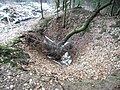
Traces of gold diggers at the gold fountain (2012)
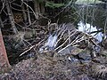
Beaver dam in the Bavarian Schwarzach in Lenkenthal (2013)

Confluence of the Bohemian (left) and Bavarian (right) Schwarzach to Schwarzach near Kritzenast


Web links
- Map of the course and catchment area of the Bavarian Schwarzach on: BayernAtlas of the Bavarian State Government ( information )
- Map of the catchment area of the Bavarian Schwarzach in Bavaria on: Map service water management, FGN Bavarian State Office for the Environment ( information )
- Area data NATURA-2000 - Bavarian Schwarzach and Biberbach
Individual evidence
Water directory Bavaria ("GV")
- ↑ a b Length according to: Directory of creek and river areas in Bavaria - Naab river area of the Bavarian State Office for the Environment, as of 2016 (PDF; 4.0 MB)
- ↑ a b Catchment area according to: Directory of stream and river areas in Bavaria - Naab river area of the Bavarian State Office for the Environment, as of 2016 (PDF; 4.0 MB)
Others
- ↑ a b BayernAtlas of the Bavarian State Government ( notes )
- ^ German Hydrological Yearbook Danube Region 2006 Bavarian State Office for the Environment, p. 160, accessed on October 4, 2017, at: bestellen.bayern.de (PDF, German, 24.2 MB).
- ↑ Teresa Guggenmoos: Die Natur, in: Heribert Batzl: The district of Oberviechtach in past and present, p. 26.
- ↑ Teresa Guggenmoos: Die Natur, in: Heribert Batzl: The district of Oberviechtach in past and present, p. 24.
- ↑ Fritsch hiking map Schönseer Land, scale 1: 35000
- ^ Pavel Valtr: Český les - jih , územní study
- ↑ Map of the catchment area on: UmweltAtlas - basic data for flowing waters Bavarian State Office for the Environment ( information )
- ↑ http://www.bayerischer-wald.de/Media/Attraktionen/Silbersee