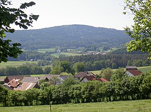
Signalberg (Upper Palatinate Forest)
| Signalberg | ||
|---|---|---|
|
Signalberg from the east |
||
| height | 888 m above sea level NHN | |
| location | Bavaria , Germany | |
| Mountains | Upper Palatinate Forest | |
| Coordinates | 49 ° 27 '49 " N , 12 ° 32' 15" E | |
|
|
||
| rock | Gneiss | |
The Signalberg is a mountain in the Upper Palatinate Forest . It is located in the municipality of Weiding in the Upper Palatinate district of Schwandorf , Bavaria between Weiding and Schneeberg .
Depending on the source, the height of the Signalberg is given as 890 m, 886 m or 888 m. The Signalberg and the 896 m high Weingartenfels are the two highest peaks in the district.
The Signalberg is the middle and highest mountain of the Frauenstein-Schneeberg massif. The Frauenstein-Schneeberg massif extends north-south between the Aschatal in the west and the valley formed by Hüttenbach and Bayerischer Schwarzach in the east.
The Signalberg is just under a kilometer southeast of the Frauenstein , about two kilometers southwest of the 789 meter high Buchsberg and about three kilometers north of the 818 meter high plate, on the summit of which there is a telecommunications tower. The Markbrunnen, the source of the Markbach, is located on the south-eastern slope of the Signalberg. The Pondorfbach rises on its south-western slope and the Schleifbach on its southern slope.
There are numerous gneiss cliffs on the summit of the Signalberg. This is the so-called Dachsbau, a geotope with the number 37A036.
literature
- Heribert Batzl (Ed.): The Oberviechtach district in the past and present. Publishing house for authorities and economy R. Alfred Hoeppner, Aßling / Obb. and Munich 1970.
Individual evidence
- ↑ Fritsch hiking map Schönseer Land, scale 1: 35000
- ^ Theodor Keck: The tourism. In: Heribert Batzl (ed.): The district of Oberviechtach in the past and present. Publishing house for authorities and economy R. Alfred Hoeppner, Aßling / Obb. and Munich 1970, p. 264.
- ^ A b c Teresa Guggenmoos: The nature. In: Heribert Batzl (ed.): The district of Oberviechtach in the past and present. Publishing house for authorities and economy R. Alfred Hoeppner, Aßling / Obb. and Munich 1970, p. 20.
- ↑ http://geoportal.bayern.de/bayernatlas/index.html?bgLayer=tk&X=5480921.18&Y=4539117.26&zoom=10&lang=de&topic=ba&layers=e528a2a8-44e7-46e9-9069-1a8295b113se_512&catalog=falersse_512&catalog=
- ↑ Fritsch hiking map of the Upper Bavarian Forest, nature park , scale 1: 50,000
- ↑ https://geoportal.bayern.de/bayernatlas/index.html?bgLayer=tk&X=5480144.46&Y=4538618.01&zoom=10&lang=de&topic=ba&layers=e528a2a8-44e7-46e9-9069-1a8295b113b512&catalog=falodesse =
- ↑ https://www.umweltatlas.bayern.de/mapapps/resources/reports/geotope/generateBericht.pdf?additionallayerfieldvalue=376A036

