Tiefenbach (Bavarian Schwarzach)
| Tiefenbach | ||
|
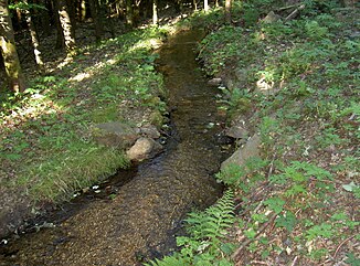
Tiefenbach above the Russenmühle |
||
| Data | ||
| Water code | EN : 14626 | |
| location |
Upper Palatinate Forest
|
|
| River system | Danube | |
| Drain over | Bavarian Schwarzach → Schwarzach (Naab) → Naab → Danube → Black Sea | |
| source | Kalterbrunnen on the south-eastern slope of Signalberg 49 ° 27 ′ 7 ″ N , 12 ° 33 ′ 2 ″ E |
|
| Source height | approx. 711 m | |
| muzzle | south of Hammertiefenbach in the Bavarian Schwarzach Coordinates: 49 ° 25 '59 " N , 12 ° 35' 48" E 49 ° 25 '59 " N , 12 ° 35' 48" E |
|
| Mouth height | approx. 485 m | |
| Height difference | approx. 226 m | |
| Bottom slope | approx. 46 ‰ | |
| length | 4.9 km | |
| Catchment area | 4.51 km² | |
| Communities | Tiefenbach (Upper Palatinate) | |
The Tiefenbach is a 5 km long right tributary of the Bavarian Schwarzach in the Cham district in Upper Palatinate in Bavaria . It rises in the Kalterbrunnen on the southeast slope of the Signalberg and flows south of Hammertiefenbach into the Bavarian Schwarzach.
Surname
The name Tiefenbach, which the brook and the village carry together, reflects the landscape. The houses in the village of Tiefenbach are located on the northeast and southwest slopes of a deeply cut valley, on the bottom of which the Tiefenbach brook runs. There is a difference in altitude of up to 60 m within the village.
course
The Tiefenbach rises in the Kalterbrunnen at an altitude of 711 m on the southeast slope of the Signalberg. From its source it turns northeast about 200 m. Then it flows in a valley cut about 400 m to the east.
In its further course it flows mainly in a south-easterly direction with a slight gradient parallel to the slope. As I can easily see (see also the photo above) a mill canal that was laid out a long time ago forms its bed. The Mühlkanal ends in the Russenmühle. From the landscape, one must assume that it originally flowed down the slope in an easterly direction and merged with the Markbach in the valley.
400 m after turning into the Mühlkanal, the Tiefenbach picks up a nameless stream flowing down from the Mühlberg from the right.
Behind the Russenmühle, the Tiefenbach turns in a south-south-east direction and now flows directly down the slope again. He feeds the "Waldbad", which is the Tiefenbach outdoor pool with a restaurant. This route is also an approximately 300 m long, dead straight, artificial canal that makes a sharp, 60 m long corner to the northwest below the forest pool.
After this corner, a natural, downhill run to the south begins again in a valley section. After about 170 m, the Tiefenbach takes on a brook from the right that rises in the gold fountain on the slopes of the Schneeberg.
The Tiefenbach now turns back to the southeast and crosses the southeast side of Tiefenbach .
The Tiefenbach leaves the village of Tiefenbach on its southeastern edge and enters gentler meadows and fields. Here it swings to the east and splits into two arms, which unite again after 400 m. The originally crystal clear forest stream becomes cloudy, brown-yellow and loamy in this section.
After another 300 m it flows from the right into the Bavarian Schwarzach, which passes the village of Tiefenbach in the east in a north-south direction.
Tributaries
From the source to the mouth.
Almost 1 km after its source, the Tiefenbach takes on a creek about 620 m long from the right, which flows down from the Mühlberg.
2.69 km after its source, the Tiefenbach takes on a 1.44 km long brook from the right. This brook has its source in the gold fountain on the slopes of the Schneeberg. It has the water code number 146262.
Individual evidence
- ↑ a b c Course and catchment area of the Tiefenbach
- ↑ a b c Length and catchment area according to: Directory of creek and river areas in Bavaria - Naab river area, page 118 of the Bavarian State Office for the Environment, as of 2016 (PDF; 4.0 MB)

