
Steinberg am See
| coat of arms | Germany map | |
|---|---|---|

|
Coordinates: 49 ° 17 ' N , 12 ° 11' E |
|
| Basic data | ||
| State : | Bavaria | |
| Administrative region : | Upper Palatinate | |
| County : | Schwandorf | |
| Management Community : | Wackersdorf | |
| Height : | 372 m above sea level NHN | |
| Area : | 20.22 km 2 | |
| Residents: | 1956 (Dec. 31, 2019) | |
| Population density : | 97 inhabitants per km 2 | |
| Postcodes : | 92449, 93149 | |
| Area code : | 09431 | |
| License plate : | SAD, BUL , NAB , NEN, OVI, ROD | |
| Community key : | 09 3 76 168 | |
| Community structure: | 6 districts | |
| Association administration address: | Marktplatz 1 92442 Wackersdorf |
|
| Website : | ||
| Mayor : | Harald Bemmerl ( SPD ) | |
| Location of the community Steinberg am See in the district of Schwandorf | ||
  |
||


Steinberg am See is a municipality in the Upper Palatinate district of Schwandorf and a member of the Wackersdorf administrative community . The municipality has had the name affix at the lake since March 31, 2006.
geography
Geographical location
Steinberg am See is centrally located in the central Upper Palatinate, about 10 kilometers east of the large district town of Schwandorf and about five kilometers southeast of Wackersdorf , which has become famous for the previously planned reprocessing plant - and thus in the middle of the Upper Palatinate Lake District , which has been in existence since the mid-1980s Years through the closure of the lignite mine . The most famous and largest lake is the Steinberger See .
Community structure
The municipality of Steinberg am See consists of the following districts:
- Haid
- Hirmerhaus
- Or (since 1961 - previously own municipality)
- Hospital (zip code 93149)
- Steinberg am See
- Waldheim
history
Steinberg takes its name from the rocky hill a few hundred meters away from the village, which is particularly noticeable in the flat stone-free quarry area. In 1185 Steinberg was first mentioned in a document from the Waldsassen monastery by Pope Lucius II . The “Parish Stainberg” was first mentioned in 1286 in the Schwandorf deanery. In a document, the Peilsteiners appear as the first farm owners in 1315. The Reisacher were the longest owners of Hofmarks (1666–1803). The family died out with Cardinal Carl August Graf von Reisach. On July 1, 1961, parts of the dissolved municipality of Oder were incorporated. In 1978 the municipality of Steinberg am See formed the administrative community of Wackersdorf together with the municipality of Wackersdorf.
Even before the great brown coal boom, granite was mined in Steinberg from the end of the 19th century. The large granite blocks from the quarry were mainly crushed to paving stones, e.g. B. the pavement of the Steinberger Friedhof comes from a local quarry.
In the course of history, the mining of lignite had a massive influence on the Steinberg am See today. As part of the Upper Palatinate lignite mining area , lignite was intensively mined in open-cast mines , especially in the area of the Steinberg am See community, in the 20th century. In the mid-1980s, the Bavarian Brown Coal Industry (BBI) stopped mining and the pits were flooded over the course of several years. This resulted in the Steinberger See and the Knappensee , among others . Since it was completely flooded at the end of the 1980s, Lake Steinberger in particular has developed into a location for water sports, tourism and local recreation.
Population development
Between 1988 and 2018 the municipality grew from 1,417 to 1,917 by 500 inhabitants or 35.3% - the highest percentage increase in the district in the period mentioned.
politics
Municipal council
After the 2014 election, three parliamentary groups with twelve seats are represented in the municipal council:
- CSU - Christian Social Union with six seats
- SPD - Social Democratic Party of Germany with five seats
- FW - Free voters with one seat
mayor
Harald Bemmerl has been the 1st mayor of Steinberg am See since May 2014.
coat of arms
Blazon : In blue over a raised golden three-mountain , a black mallet and a black iron crossed at an angle, a hovering silver eagle with a green branch in its beak.
The Steinberg local council decided on September 29, 1967 to adopt a coat of arms. It was executed by the heraldist Max Reinhart in Passau. On January 8, 1968, the State Ministry of the Interior gave its consent to the adoption of a coat of arms and the use of a flag. The flag shows three stripes in the color sequence white-blue-yellow; it can also be used with the municipal coat of arms. The municipal coat of arms depicts the story symbolically by reproducing Reisach's coat of arms guide (eagle with a branch in its beak), indicates the place name through the Dreiberg and commemorates the role of mining through the miner's symbol mallets and iron . Had the BBI not existed, the ploughshare and fishing net would probably have been the better symbols of Steinberg's development between 1200 and 1900. The coat of arms in its current form was executed by the graphic designer Stefan Josef Bittl.
In addition to the traditional coat of arms, the municipality has had its own corporate design logo and lettering since the beginning of 2016 .
Attractions
- Steinberger See
- Catholic Church of St. Wendelin
- Local history and lignite museum
tourism
With a few exceptions, tourism in the municipality of Steinberg am See is concentrated on the Steinberger See area , which was created after the end of lignite mining when the opencast mines flooded. With an area of 1.84 km², the Steinberger See is the largest lake in the Upper Palatinate. Today it is used at the same time by bathing and camping guests, sailors and water sports enthusiasts. Several cycling and hiking trails also lead around or along Lake Steinberger See. In 2018, the local hotels and holiday homes recorded a total of around 16,000 overnight guests.
Since January 2019, as part of the inMotion Park Steinberg am See, the world's largest accessible wooden ball (wooden wooden ball with adventure stations, viewing platform and tube slide) has been located on the west bank of Lake Steinberg am See at a height of 40 meters . In addition, an adventure golf course is a reminder of the coal mining around Steinberg. This is shown in the only lignite museum in southern Germany in the center of the village.

Various exhibits in front of the local history and brown coal museum
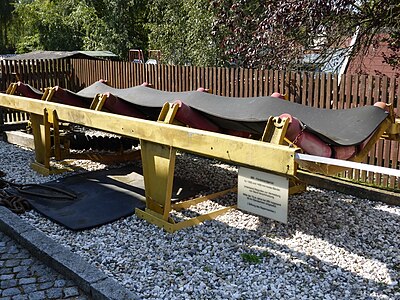
Conveyor belt scaffolding of the Bayerische Braunkohlen Industrie AG in front of the museum


Individual evidence
- ↑ "Data 2" sheet, Statistical Report A1200C 202041 Population of the municipalities, districts and administrative districts 1st quarter 2020 (population based on the 2011 census) ( help ).
- ↑ StBA: Changes in the municipalities in Germany, see 2006
- ↑ http://www.bayerische-landesbibliothek-online.de/orte/ortssuche_action.html ? Anzeige=voll&modus=automat&tempus=+20111210/184534&attr=OBJ&val= 1066
- ^ Wilhelm Volkert (ed.): Handbook of Bavarian offices, communities and courts 1799–1980 . CH Beck, Munich 1983, ISBN 3-406-09669-7 , p. 438 .
- ↑ Jakob Scharf: Steinberg. History and stories - a chronicle . 1st edition. H. Gietl Verlag & Publication Service GmbH, Regenstauf 1997, ISBN 3-924861-20-X , p. 104-106 .
- ↑ http://www.vg-wackersdorf.de/index.php?NavID=2734.26
- ↑ Local and brown coal museum Steinberg am See on oberpfaelzer-seenland.de
- ↑ Local history and lignite museum Steinberg am See on the website of the administrative community Wackersdorf
- ↑ inMotion Park Steinberg am See on dieholzkugel.de
- ^ Community of Steinberg am See: Leisure & Guests. Accessed December 20, 2017 (German).
Web links
- Entry on the coat of arms of Steinberg am See in the database of the House of Bavarian History
- Steinberg am See: Official statistics of the LfStat
- Bavarian TV film about Steinberg am See, 45 min, available until May 15, 2020

Altendorf | Bodenwohr | Bruck in the Upper Palatinate | Burglengenfeld | Dieterskirchen | Fensterbach | Slip | Guteneck | Maxhütte-Haidhof | Nabburg | Neukirchen-Balbini | Neunburg vorm Wald | Niedermurach | Nittenau | Oberviechtach | Pfreimd | Schmidgaden | Schönsee | Schwandorf | Schwarzach near Nabburg | Schwarzenfeld | Schwarzhofen | Stadlern | Steinberg am See | Stulln | Teublitz | Teunz | Thanstein | Trausnitz | Wackersdorf | Weiding | Wernberg-Koeblitz | Winklarn
Unregulated areas: Wolferlohe