
Steinberger See
| Steinberger See | ||
|---|---|---|

|
||
| Geographical location | east of the A93 | |
| Tributaries | Schreckerbach (part), (groundwater lake) | |
| Drain | Schreckerbach (part) → Kranzlohgraben → Bücherlgraben → Naab | |
| Places on the shore | Steinberg am See | |
| Data | ||
| Coordinates | 49 ° 16 '47 " N , 12 ° 9' 45" E | |
|
||
| Altitude above sea level | 364 m | |
| surface | 1.84 km² | |
| length | 1.98 km | |
| width | 1.4 km | |
| Maximum depth | 50 m | |
|
particularities |
pH value (acidic) / former lignite mining |
|

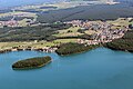
The Steinberger See belongs to the Upper Palatinate Lake District and is the largest lake in the Upper Palatinate with an area of 1.84 km² . It was named after the municipality of Steinberg am See , in whose district Oder it is located.
history
Once in the mid-1980s, the Bavarian brown coal industry (BBI) hired the degradation that has been open pit "Steinberger See" by the retraction of the dewatering flooded. Existing mining equipment was blown up and is still lying on the bottom of the lake today. Also left are two small wooded islands, which today separate the lake into a north and a south part.
The flooding lasted several years, during which the BBI advanced the necessary recultivation measures. In the meantime, a lake has developed from the former industrial desert, which not only fits into the landscape, but is also one of the sights of the Upper Palatinate.
In the last few decades tourism has also set in at Lake Steinberger See, which has given the region a certain economic boom. In addition to the Steinberger Yacht Club (SYC) founded in 1987, there is also a sailing school , a water ski lift , a boat rental, an amusement park for families and children, a surf club and, most recently, an adventure golf course and a 40 meter high wooden wooden ball "with viewing platforms, parcours and a giant slide. The leisure offer is supplemented by numerous restaurants, taverns and cafes. A water watch station has been set up for the safety of the guests . Due to the increasing improvement in water quality and visibility in recent years, Lake Steinberger See has become one of the most popular diving areas in the Upper Palatinate.
Water quality
Like all lakes in the Upper Palatinate Lake District that emerged from lignite mines , the water is acidic due to leaching. Metals are broken down within a short time; this is important when building jetties and slipways. Due to the ongoing improvement in water quality, fish populations are steadily increasing. Mainly perch and isolated pike were observed. The water is very clean, on windless days a view down to a depth of at least 10 meters is possible. Occasionally, the tops of the dead trees can be observed on the ground.
In 2013, black puddles appeared near the lake, which had a high pH value and increased heavy metal pollution . This is attributed to the fact that large quantities of toxic red mud were deposited in the empty brown coal mines in the 1960s . However, the water quality of the lake itself has not yet been affected.
Diving areas
Basically, the entire Steinberger See is released for diving in accordance with the ordinance of the Schwandorf District Office of August 8, 2002 (published in the Official Gazette for the Schwandorf District, No. 12 of August 9, 2002). Diving restrictions and bans are also explicitly stated here. At some dive sites, however, it is difficult to reach the shore due to the lack of infrastructure.
There are four dive sites to be mentioned: In the north-west there is the so-called "outlet". Because of the gently sloping bank and two practice platforms, it is mainly used for training by diving schools in the Sulzbach-Rosenberg, Schwandorf, Weiden and Regensburg area.
If you follow the bank to the south you will reach the diving spot “Rutsch'n”. From the entrance, a concrete channel slopes evenly down to a depth of 36 meters. In addition, the lake drops to 50 meters to its deepest point. However, due to the extreme cold and poor visibility at these depths, these sites should only be visited by experienced divers.
The “Beach / Forest” dive site is located on the southwestern edge of the lake. Contrary to the topography on land, the bank slopes very gently. The maximum depth that can be reached here is around 15 meters. However, orientation is difficult due to the irregular topography of the site.
On the opposite bank in the east is the “MovinGround / Wasserwacht” diving site. The Steinbergersee diving school is also located in the fun park. At depths of up to 21 meters there is a sunken boat, statue, but also various exercise platforms. The lush plant growth and the numerous fish population with mostly good visibility are the special features here. On this bank side, the no-diving zones (in the water) and the general no-diving from the beach must be observed. Entry is therefore only possible via the closed diving school / fun park or water watch.
Common to all places is the very muddy ground. It is therefore essential to avoid running aground so as not to stir up unnecessary mud. Even strokes of the fin one to two meters above the ground cause strong turbulence.
Very good visibility has been possible in recent years (up to 20 meters), especially in summer and winter. In addition to the dense vegetation of grass-like aquatic plants in the shallow area up to ten meters, remains of trees from the time of lignite opencast mining are striking.
Picture gallery

left: Steinberger Yacht-Club eV, right edge of the picture: Steinberg sailing school, lower edge of the picture: Movin'G'round eV and BRK - Schwandorf district association (water rescue service) Steinberg local group
left (bank): Movin'G'round eV and BRK - Kreisverband Schwandorf (water rescue service) local group Steinberg, right: municipality Steinberg am See

Illustration: Dam between Steinberger and Knappensee with the grounds and jetties of Seetreff Müller GmbH
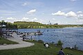
Steinberger See with water ski facility

panorama


See also
Web links
- The Upper Palatinate Lake District
- The community of Steinberg am See
Individual evidence
- ↑ Master data measuring point Steinberger See. In: gkd.bayern.de. Retrieved April 2, 2015 .
- ^ Elisabeth Hirzinger: Searching for traces on Lake Steinberger See. In: Mittelbayerische.de. August 28, 2015, accessed December 15, 2015 .