Fensterbach
| coat of arms | Germany map | |
|---|---|---|

|
Coordinates: 49 ° 24 ' N , 12 ° 2' E |
|
| Basic data | ||
| State : | Bavaria | |
| Administrative region : | Upper Palatinate | |
| County : | Schwandorf | |
| Height : | 390 m above sea level NHN | |
| Area : | 26.84 km 2 | |
| Residents: | 2364 (Dec. 31, 2019) | |
| Population density : | 88 inhabitants per km 2 | |
| Postal code : | 92269 | |
| Area code : | 09438 | |
| License plate : | SAD, BUL , NAB , NEN, OVI, ROD | |
| Community key : | 09 3 76 125 | |
| Community structure: | 12 districts | |
| Address of the municipal administration: |
Knöllinger Str. 5 92269 Fensterbach |
|
| Website : | ||
| Mayor : | Christian Ziegler (Wolfring Voting Association) | |
| Location of the community of Fensterbach in the district of Schwandorf | ||
Fensterbach is a municipality in the Upper Palatinate district of Schwandorf .
geography
The municipality is located in the Upper Palatinate North region .
Community structure
Fensterbach is only the name of the community, there is no place with this name. The municipality name is derived from the Fensterbach , which flows through the municipality.
The municipality consists of the following twelve districts:
The districts of the community of Fensterbach are Dürnsricht, Frotzersricht, Högling and Wolfring.
history
The municipality belonged to the Amberg Rent Office and the Nabburg Regional Court of the Electorate of Bavaria. Dürnsricht was subordinate to the Nabburg Nursing Court. In the closed Hofmark Wolfring the baron von Schönstätt exercised the lower jurisdiction.
Since the church was planted
The community of Fensterbach, which was newly formed on January 1, 1971, emerged from the political communities of Dürnsricht and Wolfring, founded in 1818.
The previously independent municipality of Högling and parts of the dissolved municipality of Frotzersricht were added on January 1, 1972. On January 1, 1973, part of the Ebermannsdorf community followed, which was dissolved six months later.
With the dissolution of the Freihölser forest from the Amberg-Sulzbach district on March 1, 2005, part of it was added to the municipality.
Population development
Between 1988 and 2018, the municipality grew from 2,146 to 2,347 by 201 inhabitants or 9.4%.
- 1961: 1727 inhabitants
- 1970: 1931 inhabitants
- 1987: 2138 inhabitants
- 1991: 2260 inhabitants
- 1995: 2333 inhabitants
- 2000: 2352 inhabitants
- 2005: 2452 inhabitants
- 2010: 2386 inhabitants
- 2011: 2375 inhabitants
- 2012: 2400 inhabitants
- 2013: 2398 inhabitants
- 2014: 2351 inhabitants
- 2015: 2366 inhabitants
- 2016: 2361 inhabitants
politics
Mayor and City Council
Christian Ziegler has been mayor since the early election in October 2015. The election became necessary after the death of long-time incumbent Johann Schrott in July 2015.
Allocation of seats in the municipal council from May 1, 2014:
- WG Fensterbach-Dürnsricht: 5 seats
- WG Fensterbach-Wolfring: 5 seats
- WG Fensterbach-Högling: 4 seats
coat of arms
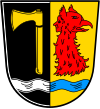
| Blazon : “Split between black and gold (yellow); above a wavy bar split by silver (white) and blue in front a golden (yellow) clearing ax, behind a red griffin head turned to the left with a human face on the neck. " | |
| Justification of the coat of arms: The coat of arms was approved by the government of the Upper Palatinate on August 23, 1977 at the suggestion of the municipal council . The wavy bar in the Bavarian colors symbolizes the Fensterbach, which flows through the municipality that was newly formed in 1971/72 from the municipalities of Dürnsricht, Wolfring, Högling and parts of Frotzersricht. At the same time he is talking to the place name. The clearing ax comes from the coat of arms of the municipality of Dürnsricht and refers to the development of the place as a clearing settlement . The red griffin head with a human face on the neck is reminiscent of the Lords of Saalhausen who, as owners of Hofmark Wolfring, had the striking castle built in Wolfring in the 16th century . |
Culture and sights
- The Catholic parish church of St. Albertus Magnus (Dürnsricht) is a Romanesque choir tower church, consecrated in 1963 by Bishop Rudolf Graber. With effect from May 1st 1969 the parish Dürnsricht-Wolfring was established and Expositus Alois Schindler, who worked in Dürnsricht since 1952, was appointed the first pastor of the new parish. In 1974 the artist Lois Wegerer created the new altarpiece for the parish church: Christ as risen in the midst of creation; above him God the Father (eye) and the Holy Spirit (dove) . Twelve years later, on June 29, 1986, the altar, the ambo and the tabernacle redesigned by Wegerer were consecrated by Bishop Manfred Müller.
- The Catholic branch church St. Margareta (Högling) is a Gothic quarry stone building (choir tower church) from the early 15th century, with rococo interior.
- The Catholic branch church St. Michael (Wolfring) is a Gothic building that was converted to Baroque style in the 18th century. On the outside there are epitaphs of the local nobility. The ceiling fresco Engelsturz from around 1910 or later was painted by the neo-baroque painter Josef Wittmann .
- Wolfring Castle in Wolfring is a multi-storey residential building made of mighty sandstone blocks and was built by Melchior von Saalhausen around 1570 (inscription). At this point there was probably a previous building from the High Middle Ages.
- See also: List of architectural monuments in Fensterbach and List of ground monuments in Fensterbach
Economy and Infrastructure
Economy including agriculture and forestry
The municipal tax revenue amounted to the equivalent of 1,144,000 euros in 1999, of which 334,000 euros (net) were trade tax revenues.
In 1998, according to official statistics, there were no employees subject to social security contributions in the manufacturing industry or in trade and transport at the place of work. In other economic areas, 56 people were employed at the place of work subject to social security contributions. There were a total of 893 employees at the place of residence subject to social security contributions. There was one company in the manufacturing sector and six companies in the construction sector. In addition, in 1999 there were 72 farms with an agricultural area of 1260 ha, of which 1037 ha were arable land and 222 ha were permanent green space.
traffic
Road traffic
State road 2151 runs through the municipality; this connects the A 93 near Schwarzenfeld with the federal highway 85 and the A 6 near Amberg .
After the completion of the gap on the A 6 between Ebermannsdorf and the Oberpfälzer Wald motorway junction, an abbreviation that had existed for years could be closed. This led to a significant reduction in the pressure on the districts located directly on the state road. So far, the unofficial direct connection has mainly been used by heavy traffic to and from Prague .
In a north-south direction, the district road 24 and the district road 25 to Trisching connect the community with the neighboring community Schmidgaden .
Rail transport
In the municipality of Freihöl, the train station is on the Nuremberg – Schwandorf railway line . It is served three times on weekdays and once on weekends ( regional express train ).
education
The following institutions exist (as of 2011):
- Kindergarten: 50 kindergarten places with 68 children
- Primary school: twelve teachers and 175 students
Web links
- Local government
- Fensterbach: Official statistics of the LfStat
- Aerial photos of the community of Fensterbach
Individual evidence
- ↑ "Data 2" sheet, Statistical Report A1200C 202041 Population of the municipalities, districts and administrative districts 1st quarter 2020 (population based on the 2011 census) ( help ).
- ↑ Municipal administration. Municipality of Fensterbach, accessed on July 3, 2020 .
- ↑ http://www.bayerische-landesbibliothek-online.de/orte/ortssuche_action.html ? Anzeige=voll&modus=automat&tempus=+20111207/232847&attr=OBJ&val= 1047
- ↑ a b Wilhelm Volkert (Ed.): Handbook of the Bavarian offices, communities and courts 1799–1980 . CH Beck, Munich 1983, ISBN 3-406-09669-7 , p. 529 .
- ^ Federal Statistical Office (ed.): Historical municipality directory for the Federal Republic of Germany. Name, border and key number changes in municipalities, counties and administrative districts from May 27, 1970 to December 31, 1982 . W. Kohlhammer GmbH, Stuttgart / Mainz 1983, ISBN 3-17-003263-1 , p. 639 .
- ↑ www.regierung.oberpfalz.bayern.de
- ↑ Description of the coat of arms


