
Waidhaus
| coat of arms | Germany map | |
|---|---|---|

|
Coordinates: 49 ° 39 ' N , 12 ° 30' E |
|
| Basic data | ||
| State : | Bavaria | |
| Administrative region : | Upper Palatinate | |
| County : | Neustadt an der Waldnaab | |
| Height : | 524 m above sea level NHN | |
| Area : | 37.33 km 2 | |
| Residents: | 2180 (Dec. 31, 2019) | |
| Population density : | 58 inhabitants per km 2 | |
| Postal code : | 92726 | |
| Area code : | 09652 | |
| License plate : | NEW, ESB , VOH | |
| Community key : | 09 3 74 164 | |
| Market structure: | 19 districts | |
Market administration address : |
Schulstr. 4 92726 Waidhaus |
|
| Website : | ||
| Mayor : | Markus Bauriedl (UWG) | |
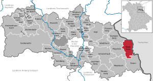
| Location of the Waidhaus market in the Neustadt an der Waldnaab district | ||
  |
||


Waidhaus (Upper Palatinate "Woihaus") is a market in the Upper Palatinate district of Neustadt an der Waldnaab on the border with the Czech Republic .
geography
Geographical location
Waidhaus is located in the Upper Palatinate North planning region on the border with the Czech Republic . Waidhaus is located at the foot of the Sulzberg, above the summit, the Old Castle , a natural forest reserve with primeval forest -like deciduous and mixed forest extends up to 755 meters . For centuries the trade route led from Nuremberg to Prague via Waidhaus.
Neighboring communities
The neighboring communities (clockwise) are: Rozvadov (Roßhaupt), Eslarn , Pleystein , Georgenberg .
|
Georgenberg 10 km |
Rozvadov (Roßhaupt) 5 km |
Rozvadov 5 km |
|
Pleystein 8 km |
.svg)
|
Rozvadov 5 km |
|
Pleystein 8 km |
Eslarn 8 km |
Eslarn 8 km |
Community structure
The community has 19 districts:
|
history
Until the church is planted
As a border town on the important trade and military route between Franconia (Imperial City of Nuremberg), the Upper Palatinate and the Kingdom of Bohemia (Pilsen, Prague), Waidhaus was the scene of heavy fighting during the Thirty Years' War : In the summer of 1621, under the command of the mercenary leader Ernst von Mansfeld, holed up there the troops of the Count Palatine Friedrich V , the so-called Winter King, who was expelled from Bohemia . They managed to hold their own against the troops of the Catholic League from July to September when the Bavarian League Lieutenant General Tilly, who was victorious in Bohemia, wanted to attack the Upper Palatinate. Mansfeld's artificially designed field fortifications have recently become the subject of archaeological investigations and represent a unique historical ensemble that promises far-reaching knowledge of early modern military architecture.
In terms of legal and administrative history, Waidhaus is documented as the seat of a land register and then a judge's office in the Treswitz nursing office and was referred to as the village of Waidhaus in the 17th century and as a market town in the 18th century . Waidhaus in today's Upper Palatinate region belonged to the Amberg Rent Office and the Treswitz Regional Court of the Electorate of Bavaria. In the course of the administrative reforms in Bavaria , today's municipality was created with the municipal edict of 1818 .
19th and 20th centuries
The market status was reassigned by King Ludwig II in 1877.
In 1945 Waidhaus became part of the American zone of occupation . The neighboring state of Czechoslovakia became the zone of influence of the Soviet Union and fortified the state border (" Iron Curtain ", border fortifications of Czechoslovakia in the Cold War ). There was a border crossing in Waidhaus. Since December 21, 2007, no border controls have been carried out there under the Schengen Agreement .
Incorporations
On July 1, 1976, areas of the dissolved communities Pfrentsch and Reinhardsrieth were incorporated.
Population development
Population development in the municipality of Waidhaus:
| year | 1840 | 1900 | 1950 | 1961 | 1970 | 1987 | 1991 | 1995 | 2000 | 2005 | 2010 | 2015 |
| Residents | 1886 | 2331 | 3286 | 2751 | 2592 | 2413 | 2440 | 2484 | 2586 | 2462 | 2372 | 2214 |
Between 1988 and 2018, the population decreased from 2,420 to 2,198 by 222 inhabitants or 9.2%.
politics
mayor
Mayor is Markus Bauriedl (UWG). He was elected on March 15, 2020 to succeed Margit Kirzinger (SPD). On May 1, 2020, Markus Bauriedl will take over the chain of mayors and thus the official business.
Market councils
Political parties and distribution of seats:
Market councils:
- Schmucker, Josef (UWG - 2nd Mayor and parliamentary group spokesman)
- Zetzl, Ewald (CSU - 3rd Mayor)
- Grötsch, Erika (UWG)
- Grundler, Rudolf jun. (SPD)
- Hoch Nicole (CSU - parliamentary group spokeswoman)
- Janisch, Ludwig (UWG)
- Kleber, Georg (Pfrentsch electoral list, PL)
- Kleber, Josef (CSU)
- Reichenberger-Hösl, Maria (CSU)
- Ringholz, Andreas (SPD)
- Schneider, Manfred (SPD)
- Stahl, Vera (SPD)
- Theiß, Ulli (UWG)
- Stuff, Johannes (SPD - parliamentary group spokesman)
coat of arms
Blazon: A silver forester's house surrounded by green trees with a red roof, the gable of which is crowned by red deer antlers, is standing in silver on green ground.
The municipality has had the coat of arms since 1877.
Culture and sights
The parish church of St. Emmeram was built in 1868 and expanded in 1953. Tombstones from the 16th to 18th centuries have been preserved near the church. The neo-Gothic Trinity Church on the outskirts was built with parts of a previous building from 1851 to 1858. It has served as an ecumenical motorway church since 2004 .
Sports
- Dart Club "Black Dogs"
- Grenzbachfischer Waidhaus
- Spickerverein Silberpfeil Waidhaus
- TSV Waidhaus 1909 eV
- Jugger
- tennis
- Soccer
- Bowling
- do gymnastics
Architectural monuments
Economy and Infrastructure
Economy including agriculture and forestry
In 1998, according to official statistics, there were 308 employees at the place of work in the manufacturing sector and 159 in the trade and transport sector. There were a total of 801 employees at the place of residence subject to social insurance contributions. There were no companies in the manufacturing sector and 1 in the construction sector. In addition, there were 72 farms in 1999 with an agriculturally used area of 1297 ha, of which 707 ha were permanent green space. For the European long-distance gas pipeline network, Waidhaus is important as an important import point for Russian natural gas and thanks to the compressor station of the Central European Gas Pipeline ( MEGAL ) in the Frankenreuth district, which begins here . The 380 kV Etzenricht – Hradec line also crosses the state border between Germany and the Czech Republic here.
Since 2000 there have been 2 wind turbines of the type B62 / 1300 in the municipality of Waidhaus, each with an output of 1300 kW and a hub height of 60 meters. The systems are at 49 ° 38'59.13 "N 12 ° 31'1.12" E and 49 ° 39'6.49 "N 12 ° 31'1.41" E.
traffic
The Waidhaus border crossing is the largest German border crossing to the Czech Republic, the A 6 is the direct motorway connection Paris - Prague . In addition to the motorway border crossing to the Czech D 5, there is also a smaller border crossing for motor vehicle traffic that leads directly to the neighboring Czech municipality of Rozvadov (Roßhaupt). The trade route, the "old military route", which has been important for centuries, runs through Waidhaus from Nuremberg to Prague, today's European route E50. The Waidhaus station on the railway line Neustadt (Waldnaab) -Eslarn is shut down.
education
There are the following institutions (as of 2018):
- Kindergartens: a day care facility with 67 places and 52 children
- Primary school: one with four primary school teachers and 53 children
Personalities
- Leonhard Gollwitzer (1682–1746), sculptor
- Karl Bauer (1922–2002), Regensburg homeland researcher, died in Waidhaus
Born in Waidhaus
- Adolf Ott (SS member) (1904–?), SS-Obersturmbannführer , leader of Sonderkommando 7b and war criminal

Parish Church of St. Emmeram

Ecumenical Motorway Church

380 kV Etzenricht-Hradec line
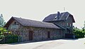
Former Waidhaus train station


Individual evidence
- ↑ "Data 2" sheet, Statistical Report A1200C 202041 Population of the municipalities, districts and administrative districts 1st quarter 2020 (population based on the 2011 census) ( help ).
- ↑ http://www.bayerische-landesbibliothek-online.de/orte/ortssuche_action.html ? Anzeige=voll&modus=automat&tempus=+20111107/184118&attr=OBJ&val= 997
- ↑ On this in detail Krüssmann: Ernst von Mansfeld . Pp. 277-291, 295-303 and 308-311.
- ↑ Contemporary illustration of this field hill: Copper engraving by Raphael Sadeler (1621) ( Memento from March 30, 2016 in the Internet Archive ) (colored), provided by the local history work group Waidhaus e. V.
- ^ Federal Statistical Office (ed.): Historical municipality directory for the Federal Republic of Germany. Name, border and key number changes in municipalities, counties and administrative districts from May 27, 1970 to December 31, 1982 . W. Kohlhammer, Stuttgart / Mainz 1983, ISBN 3-17-003263-1 , p. 652 .
- ^ Database statistical data for Bavaria
- ↑ Municipal councils on the municipality's website (as of March 1, 2019)
- ↑ http://www.thewindpower.net/wind-farm-3777.php
- ↑ An important master of the Franconian baroque . ( onetz.de [accessed June 20, 2018]).
Web links
- Waidhaus market
- Frankenreuth district
- District Pfrentsch ( Memento from March 11, 2005 in the Internet Archive )
- Entry on the coat of arms of Waidhaus in the database of the House of Bavarian History

Altenstadt an der Waldnaab |
Bechtsrieth |
Eschenbach in the Upper Palatinate |
Eslarn |
Etzenricht |
Raft |
Flossenbürg |
Georgenberg |
Grafenwohr |
Irchenrieth |
Kirchendemenreuth |
Kirchenthumbach |
Kohlberg |
Leuchtenberg |
Luhe-Wildenau |
Coat |
Moosbach |
Neustadt am Kulm |
Neustadt an der Waldnaab |
Park stone |
Pirk |
Pleystein |
Pressath |
Püchersreuth |
Umbrella seat |
Schlammersdorf |
Schwarzenbach |
Super tough |
Störnstein |
Tännesberg |
Theisseil |
Trabitz |
Vohenstrauss |
Vorbach |
Waidhaus |
Waldthurn |
Weiherhammer |
Windischeschenbach
Unregulated areas: Heinersreuther Forst | Manteler Forest | Speiny forest
Berghaus | Birklohe | Frankenreuth | Grafenau | Hagendorf | Heilinghaus | Hörlmühle | Cow mill | Marxmühle | Naglerhof | Oberströmbl | Ödkührieth | Paper mill | Pfälzerhof | Pfrentsch | Reichenau | Reinhardsrieth | Waidhaus | Zieglhütte