
Kirchendemenreuth
| coat of arms | Germany map | |
|---|---|---|

|
Coordinates: 49 ° 46 ' N , 12 ° 5' E |
|
| Basic data | ||
| State : | Bavaria | |
| Administrative region : | Upper Palatinate | |
| County : | Neustadt an der Waldnaab | |
| Management Community : | Neustadt an der Waldnaab | |
| Height : | 579 m above sea level NHN | |
| Area : | 39.31 km 2 | |
| Residents: | 858 (Dec. 31, 2019) | |
| Population density : | 22 inhabitants per km 2 | |
| Postal code : | 92665 | |
| Primaries : | 09681, 09602 | |
| License plate : | NEW, ESB , VOH | |
| Community key : | 09 3 74 128 | |
| Community structure: | 21 districts | |
| Address of the municipal administration: |
Kirchendemenreuth 28 92665 Kirchendemenreuth |
|
| Website : | ||
| Mayor : | Dr. Gerhard Kellner ( CSU ) | |
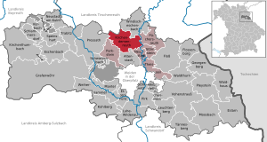
| Location of the municipality of Kirchendemenreuth in the district of Neustadt an der Waldnaab | ||
  |
||

Kirchendemenreuth is a municipality in the Upper Palatinate district of Neustadt an der Waldnaab and a member of the Neustadt an der Waldnaab administrative community .
geography
Geographical location
The municipality is surrounded by the towns of Pressath in the west, Windischeschenbach in the east, Erbendorf in the north and Altenstadt an der Waldnaab in the south on the southernmost foothills of the Fichtelgebirge and the Steinwald. The area is also known as Haberland .
Community structure
The municipality of Kirchendemenreuth has 21 districts:
|
The following districts : Old Park Stone, Döltsch, Kirchendemenreuth, Klobenreuth, Oed, Wenders Reuth.
history
Until the church is planted
Kirchendemenreuth in today's Upper Palatinate district is first mentioned in 1285 as Tiemenriut . The village was the seat of one of the seven courts of the Parkstein-Weiden Community Office , in which the Parksteiner Landrichter ruled together with twelve jury in cases of high and low jurisdiction . From 1714 the place belonged completely to the Duchy of Pfalz-Sulzbach , since 1777 it was part of the Electorate of Bavaria . In the course of the administrative reforms in Bavaria, today's municipality was created with the municipal edict of 1818.
Incorporations
On July 1, 1972, the previously independent community of Wendersreuth and areas of the dissolved communities of Altenparkstein and Schwand were incorporated. Klobenreuth was added on January 1, 1978.
Population development
- 1961: 969 inhabitants
- 1970: 939 inhabitants
- 1987: 952 inhabitants
- 1991: 943 inhabitants
- 1995: 939 inhabitants
- 2000: 971 inhabitants
- 2005: 929 inhabitants
- 2010: 888 inhabitants
- 2015: 852 inhabitants
Between 1988 and 2018, the population decreased from 943 to 869 by 74 inhabitants or 7.9%.
politics
mayor
- until 2002: Hans Lukas (CSU)
- 2002–2014: Franz Schneider (CSU)
- since 2014: Gerhard Kellner (CSU)
coat of arms
Blazon: In black, behind a silver left-hand bar, a golden oat stalk bent at the top.
The coat of arms has been used since 1982.
Architectural monuments
- Catholic Church of St. John Baptist
literature
- Heimatverein Kirchendemenreuth (Hrsg.): In the land of ears of corn: Heimat Haberland. Kirchendemenreuth community, Kirchendemenreuth 2006, ISBN 3000205063 .
- Heribert Sturm: Kirchendemenreuth in the past and present: Contributions to the history of the Haberland. Kirchendemenreuth parish 1982.
Individual evidence
- ↑ "Data 2" sheet, Statistical Report A1200C 202041 Population of the municipalities, districts and administrative districts 1st quarter 2020 (population based on the 2011 census) ( help ).
- ↑ Bayerische Landesbibliothek online - location search
- ^ Wilhelm Volkert (ed.): Handbook of Bavarian offices, communities and courts 1799–1980 . CH Beck, Munich 1983, ISBN 3-406-09669-7 , p. 537 .
- ^ Federal Statistical Office (ed.): Historical municipality directory for the Federal Republic of Germany. Name, border and key number changes in municipalities, counties and administrative districts from May 27, 1970 to December 31, 1982 . W. Kohlhammer GmbH, Stuttgart / Mainz 1983, ISBN 3-17-003263-1 , p. 652 .
Web links
- Aerial photos of the place
- Entry on the coat of arms of Kirchendemenreuth in the database of the House of Bavarian History

Altenstadt an der Waldnaab |
Bechtsrieth |
Eschenbach in the Upper Palatinate |
Eslarn |
Etzenricht |
Raft |
Flossenbürg |
Georgenberg |
Grafenwohr |
Irchenrieth |
Kirchendemenreuth |
Kirchenthumbach |
Kohlberg |
Leuchtenberg |
Luhe-Wildenau |
Coat |
Moosbach |
Neustadt am Kulm |
Neustadt an der Waldnaab |
Park stone |
Pirk |
Pleystein |
Pressath |
Püchersreuth |
Umbrella seat |
Schlammersdorf |
Schwarzenbach |
Super tough |
Störnstein |
Tännesberg |
Theisseil |
Trabitz |
Vohenstrauss |
Vorbach |
Waidhaus |
Waldthurn |
Weiherhammer |
Windischeschenbach
Unregulated areas: Heinersreuther Forst | Manteler Forest | Speiny forest