
Moosbach (Upper Palatinate)
| coat of arms | Germany map | |
|---|---|---|

|
Coordinates: 49 ° 35 ' N , 12 ° 25' E |
|
| Basic data | ||
| State : | Bavaria | |
| Administrative region : | Upper Palatinate | |
| County : | Neustadt an der Waldnaab | |
| Height : | 499 m above sea level NHN | |
| Area : | 64.32 km 2 | |
| Residents: | 2354 (Dec. 31, 2019) | |
| Population density : | 37 inhabitants per km 2 | |
| Postal code : | 92709 | |
| Area code : | 09656 | |
| License plate : | NEW, ESB , VOH | |
| Community key : | 09 3 74 137 | |
| Market structure: | 37 districts | |
Market administration address : |
Brunnenstrasse 1 92709 Moosbach |
|
| Website : | ||
| Mayor : | Hermann Ach ( CSU ) | |
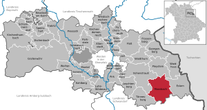
| Location of the Moosbach market in the Neustadt an der Waldnaab district | ||
  |
||

Moosbach is a market in the Upper Palatinate district of Neustadt an der Waldnaab .
geography
Geographical location
Moosbach is located in the Upper Palatinate North planning region in the Upper Palatinate Forest , a low mountain range along the border between Bavaria and the Czech Republic . The market is located around twelve kilometers from the Czech border. The highest point in the municipality is the 771 m high iceberg near the village of Rückersrieth.
Neighboring communities
The neighboring communities (clockwise) are Pleystein , Waidhaus , Eslarn , Oberviechtach , Teunz , Tännesberg , Vohenstrauß .
|
Vohenstrauss 6.5 km |
Pleystein 6 km |
Waidhaus 8.5 km |
|
Tännesberg 9 km |
.svg)
|
Eslarn 7.4 km |
|
Teunz 12 km |
Oberviechtach 14.3 km |
Oberviechtach 14.3 km |
Community structure
The municipality of Moosbach has 37 districts:
In the town hall Moosbach no longer listed as inhabited: Mühlschleif , Tradlhof
history
Until the church is planted


The Moosbach market, first mentioned in 1147, has long belonged to the Amberg Rent Office and the Treswitz Regional Court of the Electorate of Bavaria . Moosbach owned the market rights with important proprietary rights. In 1809 the responsible regional court was relocated to Vohenstrauss . In 1818 the community came into being.
Incorporations
In 1939 part of the previously independent municipality of the Netherlands was incorporated. On January 1, 1971, Grobenstädt was added. Burgtreswitz followed on April 1, 1971. In 1972, the area of the municipality of Moosbach expanded to include Tröbes and parts of the dissolved municipality of Heumaden on January 1 and Etzgersrieth and parts of the dissolved municipality of Burkhardsrieth on July 1. With effect from August 1, 2013, some parcels of the previously unincorporated Michlbach area were added to Moosbach, which means an area increase of around 35 hectares. This additional area is vacant and uninhabited.
Population development
| year | 1840 | 1900 | 1939 | 1950 | 1961 | 1970 | 1987 | 1991 | 1995 | 2000 | 2005 | 2010 | 2015 |
| Residents | 3147 | 3221 | 2624 | 3092 | 2607 | 2641 | 2639 | 2790 | 2694 | 2678 | 2553 | 2487 | 2450 |
Between 1988 and 2018, the population fell from 2,628 to 2,370 by 258 or 9.8%.
politics
City council and mayor
In the legislative period from 2014 to 2020, the municipal council is composed as follows:
| Party / list | CSU | SPD | UWG | FWU | total |
| Seats | 6th | 3 | 3 | 2 | 14th |
Mayor is Hermann Ach (CSU).
Community finances
In 2011, the municipal tax revenue amounted to 1,031,000 euros, of which 191,000 euros were trade tax revenues (net).
coat of arms
Blazon: Divided and split above; above in black a red crowned, red armored golden lion and the Bavarian diamonds; below in silver growing from blue waves a bouquet of green leaves with three black moss ears.
The coat of arms has been known since 1543.
Attractions

- Schloss Burg Treswitz , now owned by the municipality
- The parish church of St. Peter and Paul is the successor to the parish church built between 1734 and 1738, which was destroyed by fire in 1848. It was built from 1850, the shell was completed in 1853. On August 30, 1859, Bishop Ignatius of Senestrey consecrated the new church, which received its clock tower in 1861. The equipment from that time was removed in the middle of the 20th century.
- The Wies pilgrimage church, built between 1747 and 1769, is located on the northern outskirts of Moosbach. The miraculous image of the scourged Savior is based on the statue of the same name from the Wieskirche .
- The spa park with an area of eight hectares
- Hiking trails
- Hammer Waltenrieth
Economy and Infrastructure
economy
According to official statistics, there were no employees at the place of work in the field of agriculture and forestry, 180 in the manufacturing sector and 38 in the trade and transport sector. In other economic sectors, 46 people were employed at the place of work subject to social security contributions. There were a total of 854 employees at the place of residence subject to social security contributions. There were two companies in the manufacturing sector and three in the construction sector. In 2010 there were also 113 farms with a total of 3405 ha of agricultural land, of which 1995 ha were arable land and 1396 ha were meadows and pastures.
education
In 2012 (school year 2011/12) the following institutions existed:
- a kindergarten with 80 kindergarten places and 78 children
- two elementary schools with a total of 13 teachers and 190 students
sons and daughters of the town
- Gerhard Ambros (1928–2007), SED functionary
- Alfred E. Hierold (* 1941), theologian, holder of the Federal Cross of Merit, 1st class
- Hermann J. Huber (1954–2009), journalist

Moosbach (2013)

Grub with Wieskirche (2013)

Burgtreswitz, Moosbach (2013)

Etzgersrieth (2013)


Web links
- Aerial photos of Moosbach
- Entry on the coat of arms of Moosbach (Upper Palatinate) in the database of the House of Bavarian History
Individual evidence
- ↑ "Data 2" sheet, Statistical Report A1200C 202041 Population of the municipalities, districts and administrative districts 1st quarter 2020 (population based on the 2011 census) ( help ).
- ^ Moosbach BayernAtlas with municipal boundaries. Retrieved November 10, 2019.
- ↑ http://www.bayerische-landesbibliothek-online.de/orte/ortssuche_action.html ? Anzeige=voll&modus=automat&tempus=+20111106/210448&attr=OBJ&val= 979
- ^ Wilhelm Volkert (ed.): Handbook of Bavarian offices, communities and courts 1799–1980 . CH Beck, Munich 1983, ISBN 3-406-09669-7 , p. 587 .
- ^ Government of the Upper Palatinate: Community-free area "Michlbach" is dissolved , press release No. 168 of July 5, 2013, accessed on July 23, 2013

Altenstadt an der Waldnaab |
Bechtsrieth |
Eschenbach in the Upper Palatinate |
Eslarn |
Etzenricht |
Raft |
Flossenbürg |
Georgenberg |
Grafenwohr |
Irchenrieth |
Kirchendemenreuth |
Kirchenthumbach |
Kohlberg |
Leuchtenberg |
Luhe-Wildenau |
Coat |
Moosbach |
Neustadt am Kulm |
Neustadt an der Waldnaab |
Park stone |
Pirk |
Pleystein |
Pressath |
Püchersreuth |
Umbrella seat |
Schlammersdorf |
Schwarzenbach |
Super tough |
Störnstein |
Tännesberg |
Theisseil |
Trabitz |
Vohenstrauss |
Vorbach |
Waidhaus |
Waldthurn |
Weiherhammer |
Windischeschenbach
Unregulated areas: Heinersreuther Forst | Manteler Forest | Speiny forest
Burgschleif | Burgtreswitz | Etzgersrieth | Fluröd | Gaisheim | Gebhardsreuth | Gebhardsreutherschleife | Gröbenstädt | Grub | Hammer mill | Hechtlmühle | Hay shop | Greed | Kemnitzerschleif | Flax | Lohhof | Moosbach | Mill grinding | New building | Netherlands | Ödbraunetsrieth | Ödhof | Ödpielmannsberg | Pfaffenrieth | Pielhof | Pielmühle | Ragenwies | Rohrhof | Rückersrieth | Sawmill | Saubersrieth | Strehberg | Tradlhof | Trobes | Uchamühle | Waltenrieth | Wirthsschleif