
Vorbach
| coat of arms | Germany map | |
|---|---|---|

|
Coordinates: 49 ° 49 ' N , 11 ° 45' E |
|
| Basic data | ||
| State : | Bavaria | |
| Administrative region : | Upper Palatinate | |
| County : | Neustadt an der Waldnaab | |
| Management Community : | Kirchenthumbach | |
| Height : | 445 m above sea level NHN | |
| Area : | 13.54 km 2 | |
| Residents: | 998 (Dec. 31, 2019) | |
| Population density : | 74 inhabitants per km 2 | |
| Postal code : | 95519 | |
| Area code : | 09205 | |
| License plate : | NEW, ESB , VOH | |
| Community key : | 09 3 74 163 | |
| Community structure: | 7 districts | |
| Association administration address: | Bahnhofstrasse 18 91281 Kirchenthumbach |
|
| Website : | ||
| Mayor : | Werner Roder ( Free Voting Association VOH ) | |
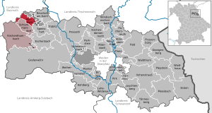
| Location of the municipality Vorbach in the district of Neustadt an der Waldnaab | ||
  |
||

Vorbach is a municipality in the Upper Palatinate district of Neustadt an der Waldnaab and a member of the Kirchenthumbach administrative community .
geography
Geographical location
Vorbach is located in the Upper Palatinate North planning region .
Community structure
The municipality of Vorbach has seven districts:
|
There are the districts Höflas, Vorbach and Oberbibrach.
history
Until the founding of the forerunner churches
The area of the municipality of Vorbach belonged to the Amberg Rent Office and the Eschenbach Regional Court of the Electorate of Bavaria . In the year 1818 the forerunners of today's municipality emerged with the municipal edict in Bavaria .
Community merger
The current municipality of Vorbach was formed on January 1, 1978 on the occasion of the Bavarian municipal area reform from the former municipalities of Vorbach and Oberbibrach.
Population development
| year | 1961 | 1970 | 1987 | 1991 | 1995 | 2000 | 2005 | 2010 | 2015 |
| Residents | 867 | 870 | 908 | 979 | 1008 | 1021 | 1047 | 1043 | 1036 |
Between 1988 and 2018 the municipality grew from 922 to 1018 by 96 inhabitants or 10.4% of the population.
politics
City council and mayor
The CSU and the Free Voting Community Vorbach-Oberbibrach-Höflas each have six seats in the local council.
Werner Roder (* 1964) (Free Voting Association VOH) has been mayor since 1996.
coat of arms
Blazon: “Split by silver and red; a red wheel hub above a lowered blue battlement beam in front, a rising silver beaver behind. ”The municipality has had the coat of arms since 1979.
Culture and sights
The medieval tower hill, seat of the Lords of Oberbibrach, as well as archaeological findings and finds in the vicinity of the rococo church of St. Johannes Evangelist in the Oberbibrach district, which was probably the castle chapel before, are listed as historical monuments.
- Architectural monuments
Sacred Heart Chapel (Höflas) in Höflas
Economy and Infrastructure
economy
According to official statistics, there were no employees at the place of work in the manufacturing sector and 68 in the trade, hospitality and transport sectors. In other areas of the economy, five people were employed at the place of work subject to social security contributions. There were a total of 408 employees at the place of residence subject to social security contributions. There was one company in the manufacturing sector and one in the main construction sector. In 2010 there were 24 farms with a total of 1102 hectares of agricultural land, of which 704 hectares were arable land and 399 hectares were permanent green areas.
traffic
Vorbach is on the Nuremberg – Cheb railway line . The station has not been served since 1992, but efforts are being made to reactivate it.
education
Location of the elementary and secondary school in Schlammersdorf.
Clubs and groups
|
|
Personalities
The organist and composer Johann Baptist Rüder (Rueder) was born in Oberbibrach on September 13, 1723 . He died in Amberg on April 7, 1807. Former Mayor Johann Hübner († 2002) had been the bearer of the Bavarian Order of Merit since July 4, 1991 .
literature
- Albert Biersack: Vorbach: (Voawa); a home book. Self-published, Amberg 1988.
- A documentation of the destruction of the villages of Oberbibrach and Vorbach and the surrounding area with statements from contemporary witnesses for posterity. Self-published, Oberbibrach 1992.
Individual evidence
- ↑ "Data 2" sheet, Statistical Report A1200C 202041 Population of the municipalities, districts and administrative districts 1st quarter 2020 (population based on the 2011 census) ( help ).
- ↑ http://www.bayerische-landesbibliothek-online.de/orte/ortssuche_action.html ? Anzeige=voll&modus=automat&tempus=+20111107/183437&attr=OBJ&val= 996
- ^ Federal Statistical Office (ed.): Historical municipality directory for the Federal Republic of Germany. Name, border and key number changes in municipalities, counties and administrative districts from May 27, 1970 to December 31, 1982 . W. Kohlhammer GmbH, Stuttgart / Mainz 1983, ISBN 3-17-003263-1 , p. 652 .
- ↑ railway relics: Station Vorbach
- ↑ Oberpfalznetz, August 16, 2013: Train has not yet departed: Vorbach is fighting for a new stop
- ↑ www.mc-oberbibrach.de
- ^ Johann Baptist Rüder in the Bavarian Musicians' Lexicon Online (BMLO)
Web links
- Entry on Vorbach's coat of arms in the database of the House of Bavarian History

Altenstadt an der Waldnaab |
Bechtsrieth |
Eschenbach in the Upper Palatinate |
Eslarn |
Etzenricht |
Raft |
Flossenbürg |
Georgenberg |
Grafenwohr |
Irchenrieth |
Kirchendemenreuth |
Kirchenthumbach |
Kohlberg |
Leuchtenberg |
Luhe-Wildenau |
Coat |
Moosbach |
Neustadt am Kulm |
Neustadt an der Waldnaab |
Park stone |
Pirk |
Pleystein |
Pressath |
Püchersreuth |
Umbrella seat |
Schlammersdorf |
Schwarzenbach |
Super tough |
Störnstein |
Tännesberg |
Theisseil |
Trabitz |
Vohenstrauss |
Vorbach |
Waidhaus |
Waldthurn |
Weiherhammer |
Windischeschenbach
Unregulated areas: Heinersreuther Forst | Manteler Forest | Speiny forest