
Pleystein
| coat of arms | Germany map | |
|---|---|---|

|
Coordinates: 49 ° 39 ' N , 12 ° 25' E |
|
| Basic data | ||
| State : | Bavaria | |
| Administrative region : | Upper Palatinate | |
| County : | Neustadt an der Waldnaab | |
| Management Community : | Pleystein | |
| Height : | 548 m above sea level NHN | |
| Area : | 42.41 km 2 | |
| Residents: | 2337 (Dec. 31, 2019) | |
| Population density : | 55 inhabitants per km 2 | |
| Postal code : | 92714 | |
| Area code : | 09654 | |
| License plate : | NEW, ESB , VOH | |
| Community key : | 09 3 74 147 | |
| LOCODE : | DE PYT | |
| City structure: | 29 districts | |
City administration address : |
Neuenhammer Strasse 1 92714 Pleystein |
|
| Website : | ||
| Mayor : | Rainer Rewitzer ( CSU ) | |
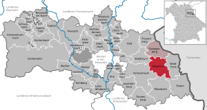
| Location of the town of Pleystein in the district of Neustadt an der Waldnaab | ||
  |
||


Pleystein is a town in the Upper Palatinate district of Neustadt an der Waldnaab in Bavaria and the seat of the Pleystein administrative community .
geography
Geographical location
Pleystein is located in the Upper Palatinate Forest, embedded in the Zottbachtal. The 801 m high Fahrenberg borders the city in the northwest.
Neighboring communities
The following communities border the city of Pleystein. They are named in a clockwise direction from the north: Georgenberg , Waidhaus , Eslarn , Moosbach , Vohenstrauß and Waldthurn .
|
Waldthurn 6 km |
Georgenberg 6.5 km |
Georgenberg 6.5 km |
|
Vohenstrauss 6 km |
.svg)
|
Waidhaus 6 km |
|
Vohenstrauss 6 km |
Moosbach 6.5 km |
Eslarn 11 km |
Community structure
The municipality of Pleystein has 29 districts:
history
Until the 19th century
The settlement was first mentioned in a document in 1242, but at that time the castle was already standing on the quartz rock in the middle of the settlement. In the second half of the 13th century, Pleystein passed to the Landgraves of Leuchtenberg .
At her intercession, Emperor Ludwig Pleystein granted Nuremberg city rights in 1331 . In 1395 the parish of St. Sigismund was founded.
In 1400 the city was partially captured by the Palatinate troops, the old town and the castle on the rose quartz rock withstood the attacks. However, the defenders, the Landgrave von Leuchtenberg and his sons, had to release the captured citizens of Neustadt. During the Hussite incursions , Pleystein was destroyed three times. During the Thirty Years' War in 1634, the troops of the Croat Colonel Marco Corpes invaded the city, plundered it and burned 48 houses, including the town hall and the office building. In the autumn of the same year, the plague broke out.

The 19th century saw a series of major fires. In 1842 eight houses with outbuildings burned and the fire of 1848 destroyed 55 houses. Eleven houses and twelve outbuildings were cremated in 1899.
20th century
The city was hit by the biggest fire on July 10, 1901. The fire that broke out in the former Grabenmühle destroyed 72 main and 78 auxiliary buildings, including the two churches.
After the Second World War , the population increased due to the influx of refugees. Today Pleystein has around 2700 inhabitants with the incorporated districts. Pleystein has been a state-approved resort since 1957. Since 1978 Pleystein has been the seat of the administrative association. In 1979 it was designated as a small center.
Incorporations
On January 1, 1972, as part of the regional reform in Bavaria, the previously independent communities Lohma and Miesbrunn and parts of the dissolved communities Bernrieth were incorporated. On July 1, 1972, parts of the former municipality of Burkhardsrieth followed.
Population development
Between 1988 and 2018 the population decreased from 2,569 to 2,367 by 202 inhabitants or 7.9%.
politics
City council
After the local elections on March 16, 2014 , the Pleystein City Council is composed as follows:
| CSU | SPD | FW | total | |
|---|---|---|---|---|
| 2014 | 7th | 3 | 4th | 14th |
mayor
Rainer Rewitzer has been the mayor since May 2014.
coat of arms
Blazon: In black over a green three-mountain, a red crowned and red armored golden lion, covered in the middle with a narrow bar, which is covered in two rows with silver and blue diamonds.
The coat of arms has been known since 1556.
Town twinning
The municipalities of Bor u Tachova in the Czech Republic and Gamlitz in southern Styria (Austria) are partner municipalities of Pleystein.
Attractions
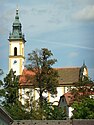
Heiligkreuz pilgrimage church

St. Sigismund


Buildings and monuments
- The neo-baroque pilgrimage church Heiligkreuz (Kreuzbergkirche) was completed in 1904. The previous pilgrimage church, built in 1814, burned down in 1901. Next to the church are the buildings of today's Salesian monastery .
- The neo-Gothic parish church of St. Sigismund was also built after the great fire from 1901 to 1904.
- War memorial with statue of the Virgin Mary
- St. Nepomuk statue from 1731 on the market square
- Mountain church St. Ulrich in the district of Burkhardsrieth
- Many chapels, wayside crosses and martyrs
Museums
- City museum (next to the parish church) with changing exhibitions and a large mineral collection, the Lehner collection
- Katharina's doll house (Hagenmühle near Pleystein)
Natural monuments
- Kreuzberg in Pleystein , 38 m high rose quartz rock (one of the 100 most beautiful geotopes in Bavaria)
traffic
The Pleystein station on the former Neustadt (Waldnaab) –Eslarn railway line has been closed.
In the south, the A6 motorway runs with junction 75 “Pleystein”.
Personalities
- Johann Baptist von Anzer (1851–1903), bishop of the German mission to China in Shandong Province
- Kurt Benning (1945–2017), draftsman, photographer and painter
- Johann Hoffmann (unknown – 1706), leader of the Bavarian popular uprising in 1706 in Braunau am Inn
- Johann Nepomuk Hortig (1774–1847), theologian and professor
- Siegfried Poblotzki (1917–1997), local history researcher, author of the history of the town and the Pleystein rule
- Benedikt Schopper (* 1985), ice hockey player
- Brigitte Traeger (* 1973), pop singer, lives in Pleystein
- Johann Weig (1867–1948), Steyler missionary
- Georg Michael Wittmann (1760–1833), auxiliary bishop in Regensburg
Web links
- Entry on the coat of arms of Pleystein in the database of the House of Bavarian History
- Website of the city of Pleystein
- Aerial views of the city
- Pleystein: Official statistics of the LfStat
Individual evidence
- ↑ "Data 2" sheet, Statistical Report A1200C 202041 Population of the municipalities, districts and administrative districts 1st quarter 2020 (population based on the 2011 census) ( help ).
- ↑ Pleystein BayernAtlas with municipal boundaries. Retrieved November 10, 2019.
- ↑ http://www.bayerische-landesbibliothek-online.de/orte/ortssuche_action.html ? Anzeige=voll&modus=automat&tempus=+20111107/165449&attr=OBJ&val= 984
- ↑ Siegfried Poblotzki , History of the City and Rule Pleystein 1968 and 1980
- ^ Wilhelm Volkert (ed.): Handbook of Bavarian offices, communities and courts 1799–1980 . CH Beck, Munich 1983, ISBN 3-406-09669-7 , p. 587 .
- ↑ http://www.wahlen.bayern.de/kommunalwahlen/
- ↑ Mindat - Mineralfundort Kreuzberg (Rose quartz cliff), Pleystein, Vohenstrauß, Oberpfälzer Wald, Upper Palatinate, Bavaria, Germany (English)

Altenstadt an der Waldnaab |
Bechtsrieth |
Eschenbach in the Upper Palatinate |
Eslarn |
Etzenricht |
Raft |
Flossenbürg |
Georgenberg |
Grafenwohr |
Irchenrieth |
Kirchendemenreuth |
Kirchenthumbach |
Kohlberg |
Leuchtenberg |
Luhe-Wildenau |
Coat |
Moosbach |
Neustadt am Kulm |
Neustadt an der Waldnaab |
Park stone |
Pirk |
Pleystein |
Pressath |
Püchersreuth |
Umbrella seat |
Schlammersdorf |
Schwarzenbach |
Super tough |
Störnstein |
Tännesberg |
Theisseil |
Trabitz |
Vohenstrauss |
Vorbach |
Waidhaus |
Waldthurn |
Weiherhammer |
Windischeschenbach
Unregulated areas: Heinersreuther Forst | Manteler Forest | Speiny forest