
Franconian Way of St. James
| Franconian Way of St. James | |
|---|---|
 Tillyschanz Jakobsweg information board |
|
| Data | |
| length | 264 km |
| location | Bavaria |
| Markers | |
| Starting point |
Tillyschanz 49 ° 35 ′ 3.4 " N , 12 ° 34 ′ 35.5" E |
| Target point |
Rothenburg ob der Tauber 49 ° 22 ′ 37.7 ″ N , 10 ° 10 ′ 44.7 ″ E |
| Type | Long-distance hiking trail |
| Level of difficulty | light |
| season | Spring to autumn |

The Franconian Way of St. James is a section of the Way of St. James in Bavaria . It was inaugurated in 1995 and leads - marked on the Czech side as "I 24" - coming from Prague at Tillyschanz over the German-Czech border, first through the Upper Palatinate and then through Franconia via Nuremberg to Rothenburg ob der Tauber . There it continues through the Franconian-Swabian Way of St. James .
history
Pastor Paul Geißendörfer from Heilsbronn described the almost forgotten medieval Way of St. James between Nuremberg and Rothenburg ob der Tauber in 1992. The Franconian Alb Association took up the suggestion and, in collaboration with the Upper Palatinate Forest Association, marked the route from Tillyschanz to Rothenburg ob der Tauber. The two hiking guides mentioned under literature appeared. The parishes along the way tried to create inexpensive accommodation for the pilgrims. Since then, pilgrims have enjoyed increasing popularity on this very lonely section of the Camino de Santiago.
First part: Tillyschanz to Nuremberg
The Way of St. James is clearly marked with a white shell on a light blue background. This section is supervised by the Franconian Alb Association and the exact course is completely recorded in OpenStreetMap . It runs mainly on forest, meadow and field paths. Only rarely do you have to walk a short stretch of road or paved path. Nevertheless, it is advisable to take hiking maps, a compass and hiking guide as well as food with you, as the path partly leads through vast lonely forest areas and very small towns without grocery stores.

Tillyschanz – Teunz section, 23.5 km
The Way of St. James begins at the Tillyschanz border crossing in the middle of the Upper Palatinate Forest in the Neustadt an der Waldnaab district . Well marked it leads west to Eslarn . At the south-western exit of Eslarn, at the Eslarner Waldbad Atzmannsee, the path turns south and leads north past the Stangenberg summit, out of the dense forest again to the west to an open area with the hamlets of Lohhof and Gaisheim . Then again to the southwest through an extensive forest area to Wildstein , where he changes to the district of Schwandorf . From Wildstein it goes south via Kühried and Burkhardsberg to the first Jakobskirche, a baroque corridor chapel from the 18th century, on the slope of the 596 m high plate east of Fuchsberg . Continue through Fuchsberg, past the small Fuchsberg bathing pond to Teunz .
Section Teunz – Schwandorf, 40 km
The path is often difficult to find, especially at the beginning of this section. It often gets lost in the forest or in the meadows and is completely overgrown. Orientation using a mobile phone or GPS is often difficult due to a lack of network reception and poor GPS reception. A normal mechanical compass is very useful for orientation there. The Ostmarkstrasse (B 22) is crossed southwest of Teunz . Generally in a south-westerly direction via Voggendorf , Rottendorf , Enzelsberg , Oberkatzbach , Guteneck , Schirmdorf to the Romanesque Jakobskirche in Willhof . In Willhof the route turns south and runs via Unterkonhof , Mitterauerbach to Wundsheim . From Wundsheim further west via Glöcklhof to Hohenirlach . Between Hohenirlach, Holzhaus and Schwandorf , the path winds south-west between numerous shallow ponds in the Upper Palatinate Lake District, which were created through lignite and gravel mining at the beginning of the 20th century and now form a nature reserve that offers refuge for numerous endangered animal and plant species.

Schwandorf – Hohenburg section, 31 km
In Schwandorf there is a St. James' Church built in the 15th century on the market square. It continues westwards along the Naab to Ettmannsdorf , Naabsiegenhofen , Neukirchen , Scheckenberg to Siegenthan , where the path leaves the Schwandorf district and changes to the Amberg-Sulzbach district . Via Dornberg it goes to Ensdorf an der Vils , where there is a Jakobskirche built in the 18th century in the Wittelsbach monastery in Ensdorf . Head southwest over the Eggenberg with the pilgrimage church of St. Dionys and Nothelfer via Taubenbach , Egelsheim , Stettkirchen to Hohenburg .

Hohenburg – Sindlbach section, 36 km
The Catholic parish church of St. Jakob the Elder, built in the 17th century, is located in the southwest of Hohenburg. The Way of St. James now runs north-west, always along the Lauterach , which flows on its right, via Allersburg , Ransbach , Lauterach to Kastl with its former Benedictine monastery , where it leaves the river. Here the Way of St. James changes from the Amberg-Sulzbach district to the Neumarkt district in the Upper Palatinate . To the southwest it goes up to Nattershofen and then to the west via Trautmannshofen , Langenthal to Sindlbach .

Sindlbach – Feucht section, 22 km
In the Jakobskirche von Sindlbach, built in the 17th century, there is a depiction of St. Jakob as a Moorslayer in the middle ceiling painting. From Sindlbach the route almost always leads west via Irleshof to Gnadenberg , where the Way of St. James leaves the district of Neumarkt in the Upper Palatinate and the Upper Palatinate and changes to Middle Franconia in the district of Nürnberger Land . The change is clear: there are hardly any beer gardens left, there are fewer inns at all, the towns seem more affluent, the churches are no longer Catholic but Protestant. The path leads via Rasch , Prackenfels , Grünsberg , Altenthann , Rummelsberg to Feucht . In addition to the towns and churches, Grünsberg Castle , the Sophienquelle and the Thanngraben near Altenthann are worth seeing.

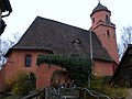
St. Michael in Rasch
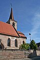
Sankt Veit in Altenthann


Feucht – Nuremberg, 24 km
In Feucht, the church of St. James, which dates back to a building from the 12th century, proves that the route of the medieval St. James' Way is right here. After Feucht, the path leaves the district of Nürnberger Land and changes to the district of Roth . In the district of Roth, the Way of St. James crosses the villages of Röthenbach near Sankt Wolfgang and Wendelstein . Then it leads through the villages of Worzeldorf , Pillenreuth , Reichelsdorf and Gerasmühle, which are incorporated into Nuremberg . He leaves the city of Nuremberg and moves to the Fürth district . The first part of the Franconian Way of St. James ends in Stein .

Jakobskirche in Feucht
St. Wolfgang in Röthenbach b.St. wolfgang

St. Georg in Wendelstein
_02.jpg)

_01.jpg)
Second part: Nuremberg to Rothenburg ob der Tauber
Section Nuremberg – Weihenzell, 44 km
From Nuremberg the Way of St. James leads more or less strictly west to Rothenburg ob der Tauber. From Stein it goes via Oberweihersbuch , Unterbüchlein , Weitersdorf , Roßtal , Buttendorf , Fernabrünst to Wendsdorf . Here the route changes from the Fürth district to the Ansbach district . It continues via Bürglein , Heilsbronn , Großhaslach , Reckersdorf , Forst to Weihenzell .
Section Weihenzell – Rothenburg ob der Tauber, 46 km
From Weihenzell the route leads via Wernsbach near Ansbach , Röshof , Buhlsbach , Lehrberg , Unterheßbach , Häslabronn , Colmberg , Oberhegenau , Binzwangen , Stettberg , Karrachmühle , Wachsenberg to Rothenburg ob der Tauber.
Regions
The Franconian Way of St. James leads in the Bavarian administrative district of Upper Palatinate through the districts of Neustadt an der Waldnaab, Schwandorf, Amberg-Sulzbach and Neumarkt in the Upper Palatinate. In the Bavarian administrative district of Middle Franconia , it leads through the districts of Nürnberger Land, Roth, Nürnberg-Stadt, Fürth and Ansbach.
literature
- Fränkischer Albverein (Ed.): On the Jakobsweg from Tillyschanz via Schwandorf to Nuremberg. Verlag Seehars, 97215 Uffenheim 1997, ISBN 3-927598-22-4
- Fränkischer Albverein (Ed.): On the Jakobsweg from Nuremberg via Heilsbronn to Rothenburg ob der Tauber. Verlag Seehars, 97215 Uffenheim 1995, ISBN 3-927598-18-6
Web links
- http://www.fernwege.de/d/jakobsweg/tillyschanz-bodensee/001/index.html Jakobsweg from Tillyschanz
Individual evidence
- ↑ Český les jih Turistická mapa. VKU akciová spoločnost´, Harmanec 2004
- ^ Fränkischer Albverein (Ed.): On the Way of St. James from Tillyschanz via Schwandorf to Nuremberg. Verlag Seehars, 97215 Uffenheim 1997, ISBN 3-927598-22-4 , p. 7
- ^ Fränkischer Albverein (Ed.): On the Way of St. James from Tillyschanz via Schwandorf to Nuremberg. Verlag Seehars, 97215 Uffenheim 1997, ISBN 3-927598-22-4 , p. 9
- ^ Fränkischer Albverein (Ed.): On the Way of St. James from Nuremberg via Heilsbronn to Rothenburg ob der Tauber. Verlag Seehars, 97215 Uffenheim 1995, ISBN 3-927598-18-6 , p. 23
- ^ Fränkischer Albverein (Ed.): On the Way of St. James from Tillyschanz via Schwandorf to Nuremberg. Verlag Seehars, 97215 Uffenheim 1997, ISBN 3-927598-22-4 , p. 7
- ^ Fränkischer Albverein (Ed.): On the Way of St. James from Tillyschanz via Schwandorf to Nuremberg. Verlag Seehars, 97215 Uffenheim 1997, ISBN 3-927598-22-4 , p. 6
- ^ Fränkischer Albverein (Ed.): On the Way of St. James from Tillyschanz via Schwandorf to Nuremberg. Verlag Seehars, 97215 Uffenheim 1997, ISBN 3-927598-22-4 , p. 9
- ↑ Jakobsweg, section Ensdorf - Stein (accessed on February 1, 2013)
- ^ Fränkischer Albverein (Ed.): On the Way of St. James from Tillyschanz via Schwandorf to Nuremberg. Verlag Seehars, 97215 Uffenheim 1997, ISBN 3-927598-22-4 , p. 7
- ↑ Interactive route plan for the Jakobsweg section Tillyschanz-Teunz
- ^ Fränkischer Albverein (Ed.): On the Way of St. James from Tillyschanz via Schwandorf to Nuremberg. Verlag Seehars, 97215 Uffenheim 1997, ISBN 3-927598-22-4 , pp. 10-24
- ↑ Interactive route plan of the Jakobsweg section Teunz-Schwandorf
- ^ Fränkischer Albverein (Ed.): On the Way of St. James from Tillyschanz via Schwandorf to Nuremberg. Verlag Seehars, 97215 Uffenheim 1997, ISBN 3-927598-22-4 , pp. 24, 25
- ^ Fränkischer Albverein (Ed.): On the Way of St. James from Tillyschanz via Schwandorf to Nuremberg. Verlag Seehars, 97215 Uffenheim 1997, ISBN 3-927598-22-4 , pp. 24-36
- ↑ Interactive route plan Jakobsweg section Schwandorf-Hohenburg
- ^ Fränkischer Albverein (Ed.): On the Way of St. James from Tillyschanz via Schwandorf to Nuremberg. Verlag Seehars, 97215 Uffenheim 1997, ISBN 3-927598-22-4 , pp. 36-68
- ↑ Interactive route plan for the Jakobsweg section Hohenburg-Sindlbach
- ^ Fränkischer Albverein (Ed.): On the Way of St. James from Tillyschanz via Schwandorf to Nuremberg. Verlag Seehars, 97215 Uffenheim 1997, ISBN 3-927598-22-4 , pp. 68-89
- ↑ Interactive route plan for the Way of St. James, Sindlbach-Feucht section
- ↑ Interactive route plan for the Way of St. James, Feucht-Nuremberg section
- ^ Fränkischer Albverein (Ed.): On the Way of St. James from Tillyschanz via Schwandorf to Nuremberg. Verlag Seehars, 97215 Uffenheim 1997, ISBN 3-927598-22-4 , pp. 89-142
- ↑ Interactive route plan for the Jakobsweg section Nuremberg-Weihenzell
- ^ Fränkischer Albverein (Ed.): On the Way of St. James from Nuremberg via Heilsbronn to Rothenburg ob der Tauber. Verlag Seehars, 97215 Uffenheim 1995, ISBN 3-927598-18-6 , pp. 24-71
- ↑ Interactive route plan for the Jakobsweg section Weihenzell-Rothenburg ob der Tauber
- ^ Fränkischer Albverein (Ed.): On the Way of St. James from Nuremberg via Heilsbronn to Rothenburg ob der Tauber. Verlag Seehars, 97215 Uffenheim 1995, ISBN 3-927598-18-6 , pp. 71-109
- ↑ Interactive route plan of the Jakobsweg overview map Tillyschanz-Rothenburg ob der Tauber