
Thanngraben near Schwarzenbruck
| Thanngraben | ||
|---|---|---|
 Rocks in the Thanngraben |
||
| location | District of Nürnberger Land , Bavaria | |
| Waters | Höhenbach | |
| Mountains | Franconian Alb | |
| Geographical location | 49 ° 22 '5 " N , 11 ° 18' 16" E | |
|
||
| Type | canyon | |
| rock | Rhätsandstein , Burgsandstein | |
| particularities | Protected landscape component | |

The Thanngraben is a Rhaetian sandstone gorge and begins west of Altenthann near Schwarzenbruck in the Middle Franconian district of Nürnberger Land . The small and narrow gorge ends after about three kilometers at the Fröschauer Weihern near Rummelsberg .
description
The small, formerly wild and romantic gorge begins near Altenthann . It is surrounded by heavily weathered sandstone rock formations. A brook that rises near the St. Veit Church in Althentann gave the gorge its name. In the further course there are numerous springs and after about a thousand meters the stream is called Höhenbach . It flows into the Schwarzach near Ochenbruck . At the upper end of the gorge, where coarse-grained and hard sandstones are underlain by softer ones, a small fish pond has been artificially created. To the north of the pond there is a memorial stone that commemorates the building of the main collector Altenthann. The wastewater from Altenthann is piped through the Thanngraben and fed to the treatment plant in Schwarzenbruck. In 2013, a wide, gravel forest road was built through part of the gorge and thus impaired the picturesque appearance.
In the upper part of the gorge, rock cellars were created, but they are in danger of collapsing.
geology
Over the millennia, the brook has dug its way into the layers of the Rhät- Lias sandstone and the Upper Feuerletten, producing natural rock outcrops. About 200 million years ago, in the transition period between the Triassic (Upper Keuper, Rhaet) and the Jura (Lias), there was a shallow inland sea in Central Franconia in the northwest and the mainland in the southeast. Fine-grained and sandy sediments were deposited in this sea , which later solidified into clay and sandstone. Since it is not possible to clearly distinguish which of the rocks are to be assigned to the Rhaetian and which to the Lias, these are called the Rhaet-Lias transition layers. The brown-gray Rhätsandstein can be found on the upper slopes and the upper reaches of the Thanngraben.

tourism
The Thanngraben is a near-tourist destination and is accessible all year round. The marked hiking trail Fränkischer Jakobsweg leads through the gorge. A few kilometers to the west is the Schwarzachklamm .
Picture gallery
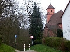
St. Veit in Altenthann at the beginning of the Thanngraben

Fish pond in winter

Memorial stone main collector Altenthann
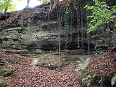
rock

Rock with rock cellar

Thanngraben near Fröschau
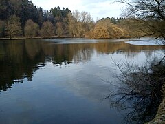
Fröschauer Weiher at the end of the Thanngraben


Individual evidence
- ↑ Thanngraben hiking suggestion ( Memento of the original from December 1, 2014 in the Internet Archive ) Info: The archive link was automatically inserted and not yet checked. Please check the original and archive link according to the instructions and then remove this notice.
- ↑ OpenStreetMap: Jakobsweg