Lion's Arch Formation
The Löwenstein Formation ( Stubensandstein in Baden-Württemberg, Burgsandstein in Bavaria) is a lithostratigraphic formation of the Keuper in the Germanic Triassic . The lithostratigraphic unit is underlain by the Mainhardt Formation and overlaid by the Trossingen Formation .
definition
The lower limit of the Löwenstein Formation is defined by the insertion of the sandstones of the "Stuben" or "Burgsandsteins", the upper limit by the exposure of the sandstones. Both the lower and upper bounds are strongly diachronous . The lower limit is often even discordant . The Löwenstein Formation meshes with the Weser Formation towards the North German Basin, and in the upper parts with the Exter Formation . To the south-east it spreads far into the Vindelician country , further than the older formations.

The Löwenstein Formation consists of light, fine to coarse-grained sandstones with individual conglomerate layers , which have a high proportion of feldspar and clay . The sandstones interlock laterally with colored clay stones . There are several clay layers between the compact sandstone packages . There are also several carbonate horizons , but their genesis is different. The crustal limestone, for example, suggests former soil horizons . Some dolomite banks that have regional significance as leading horizons are also switched on (e.g. Schützlinger Bank, Ochsenbachbank, Rottweiler Bank and Herrenberger Bank). The average thickness is about 120 to 140 m; it goes back to 10 m in southern Baden-Württemberg. The Löwenstein Formation is dated from the Middle Norium to the Lower Rhaetian ( Upper Triassic ). A type profile still has to be defined. The type region is the Löwenstein Mountains in northern Baden-Württemberg , from which the name is derived.
structure
The Löwenstein Formation has not yet been formally subdivided, but a lithological breakdown into three sandstone units is recommended :
- Upper Stubensandstein (Upper Burgsandstein)
- Middle Stubensandstein (Middle Castle Sandstone)
- Lower Stubensandstein (Lower Castle Sandstone)
The correlation of the units in Baden-Württemberg and Bavaria is the same, even if corrections have to be made in details. Regionally, the carbonate banks can also be used for correlation.
Storage room
The sandstones of the Löwenstein Formation were created in a dry, hot desert to semi-desert climate ( arid climate ) by stratified floods from erosion material from the Vindelici threshold in the southeast. The massive sandstones were created in river channels (conglomerates!). In the intermediate flood plains, there was also soil formation in the form of limestone and pebble crusts. Soil horizons are also documented by carbonaceous layers and traces of roots.
Fossils
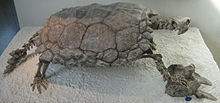
The sandstones of the Löwenstein Formation contain plant remains , fossils of terrestrial vertebrates and fish as well as freshwater clams ( Unionids ). Tracks and other Ichnotaxa were found on the layered surfaces . In the Dolomites banks a rich individuals came mussel , - snails - and mussel cancer -Fauna to light. A well-known fossil is the approximately one meter long "primeval turtle" Proganochelys quenstedti (Baur, 1887) from the Upper Stubensandstein. Characteristics of the early stage of development in the tribal history of the turtles (Testudinata) are still existing teeth on the palatine bone and the not yet developed ability to hide the head and neck under the bone armor . Another “Urschildkröte” Murrhardtia staeschei was described in 2000 by Karl & Tichy from the Lower Stubensandstein in Murrhardt (Baden-Württemberg). However, this already belongs to a phylogenetic branch that was closer to that of today's turtles than Proganochelys quenstedti .
Economical meaning
The parlor sandstone was an important building block for churches and town halls in the Middle Ages . However, it is very susceptible to weathering . The intermediate layers were used as pottery clay . The layers could also be easily ground into sand, which was then mainly used in the manufacture of mortar , but also as litter and scouring sand for streets or the wooden floors of domestic living rooms, which explains the name of the parlor sandstone. Its gold content led to the creation of gold washing facilities in many places , which however had to be abandoned after a short time due to the low yield. Stubensandstein z. B. Dettenhausen sandstone can also be very hard and weather-resistant and was then also used for millstones or foundation stones.
geomorphology

The relatively soft sandstone, which can absorb water well and can be easily removed from under the harder Keup layers, contributes significantly to the formation of the landscape in the central Neckar area as a base- forming element . Above all, the Stuttgarter Klingen , deep gorges cut into the Keuper , have been shaped by the layers of Stuben sandstone. A typical walk-gorge through which a geographical trail leads, is as a V-shaped valley formed Schwälblesklinge . A geological nature trail opens up the Stubensandstein in the Kirnbachtal of Schönbuch near Tübingen .
literature
- Gerhard Beutler: Lithostratigraphy. In: German Stratigraphic Commission (Ed.): Stratigraphie von Deutschland IV - Keuper. Courier Forschungsinstitut Senckenberg, 253: 65-84, Stuttgart 2005 ISSN 0341-4116
- Gerhard Beutler, Norbert Hauschke and Edgar Nitsch: Facies development of the Keuper in the Germanic Basin. In: Norbert Hauschke & Volker Wilde (eds.): Trias - A completely different world - Central Europe in the early Middle Ages. Pp. 129–174, Verlag Dr. Friedrich Pfeil, Munich 1999 ISBN 3-931516-55-5
- Hans-Volker Karl and Gerhard Tichy: Murrhardtia staeschei n. Gen. N. Sp. - a new turtle from the Upper Triassic of southern Germany. Joannea Geology and Paleontology 2: 57-72, Graz 2000 ISSN 1562-9449
- Edgar Nitsch: The Keuper in the Stratigraphic Table of Germany 2002: Formations and consequences. Newsletters on Stratigraphy, 41 (1-3): 159-171, Stuttgart 2005 ISSN 0078-0421
Individual evidence
- ↑ Johannes Baier: The geological educational trail on the Kirnberg (Keuper; SW Germany) . - Jber. Middle Upper Rhine. geol. Ver, NF 93, 9-26, 2011.
Web links
- German Stratigraphic Commission (Ed.): Stratigraphische Tisch von Deutschland 2002 . Potsdam 2002 ISBN 3-00-010197-7 - [1] (large; PDF; 6.9 MB) (abbreviated STD2002)
- Geographic nature trail


