
Swallow blade
| Swallow blade | ||
 |
||
| Data | ||
| Water code | DE : 2383452 | |
| location |
Filder
|
|
| River system | Rhine | |
| Drain over | Nesenbach → Neckar → Rhine → North Sea | |
| source | near Stuttgart- Sonnenberg 48 ° 44 '52 " N , 9 ° 8' 53" E |
|
| Source height | approx. 370 m above sea level NHN | |
| muzzle | between Kaltental and Heslach from the right and east-northeast in the upper Nesenbach Coordinates: 48 ° 44 '49 " N , 9 ° 8' 11" E 48 ° 44 '49 " N , 9 ° 8' 11" E |
|
| Mouth height | approx. 310 m above sea level NHN | |
| Height difference | approx. 60 m | |
| Bottom slope | approx. 66 ‰ | |
| length | 914 m | |
| Catchment area | 80 ha | |
The Schwälblesklinge is a small notch valley in the Kaltental district of Stuttgart . The origins and backgrounds are explained on a geographical educational trail using display boards. In the Schwälblesklinge there are clear weathering hollows, which clearly illustrate the erosion processes in the formation of layered landscapes and so-called blades .
A creek of the same name, almost a kilometer long, flows through the Schwälblesklinge and flows into the Nesenbach in Stuttgart-Süd .
Location and origin
The Schwälblesklinge begins on the north-western edge of the Sonnenberg district , runs westward and flows into the Nesenbach valley at the northern end of Kaltental . It has a length of around one kilometer. To the right above their incision is the Stuttgart Forest Cemetery .
The Schwälblesklinge was mainly formed by deep erosion during the last ice age . In order to protect the forest path that runs right next to the stream, the bank and stream bed were built. In addition to the sandstones and marls to the east, there are also shell limestone and granite in the stream bed . To regulate the flow of water, shell limestone was first introduced, later granite was introduced as a " rough ramp " as part of a near-natural river design . When it rains heavily, the valley becomes even wider and deeper.
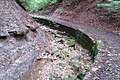
On the left, an eroding slope, on the right a paved path
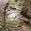
Natural stream bed made of rock slabs inclined from the horizontal; Look upstream

Artificially fortified stream bed

Fritz-Keller -Brünnele at the upper entrance to the valley


Web links
- Description of the educational trail at the Institute for Geography at the University of Stuttgart
Individual evidence
- ^ Friedrich Huttenlocher , Hansjörg Dongus : Geographical land survey: The natural spatial units on sheet 170 Stuttgart. Federal Institute for Regional Studies, Bad Godesberg 1949, revised 1967. → Online map (PDF; 4.0 MB)
- ↑ a b c d State Institute for the Environment Baden-Württemberg (LUBW) ( information )