
Schwarzach Gorge near Schwarzenbruck
|
Schwarzach breakthrough
|
||
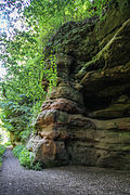
 Rocks near Gsteinach |
||
| location | Schwarzenbruck | |
| surface | 38.2685 | |
| Identifier | NSG-00300.01 | |
| WDPA ID | 165487 | |
| Natura 2000 ID | DE6633371 | |
| Geographical location | 49 ° 21 ' N , 11 ° 13' E | |
|
||
| Setup date | 1936 | |
| administration | Nuremberg country | |

The Schwarzach Gorge is a gorge-like river valley about 2.2 kilometers long south of Schwarzenbruck in the Middle Franconian district of Nürnberger Land in Bavaria . It is named after the river Schwarzach .
location
The gorge is on the southern border of the Lorenzer Reichswald in Middle Franconia . The river forms the border between the Nürnberger Land district in the north and the Roth district . To the west the gorge ends at the Brück Canal and to the east south of the Schwarzenbruck district of Gsteinach near the Schwarzenbrucker Moor nature reserve .
Geotope
The Schwarzach Gorge is also called the Schwarzach Gorge or the Schwarzach Gorge. The gorge is designated by the Bavarian State Office for the Environment as geotope 574R001 and has been awarded the official seal of approval " Bavaria's most beautiful geotopes ". See also the list of geotopes in the district of Nürnberger Land .
Nature reserve
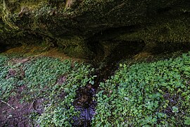
The entire gorge has been a designated 41 hectare nature reserve since 1936 and has the cadastral number NSG-00300.01. The main reason for the protection is the abundance of mosses . In addition directly on the river alder - riparian forests and mixed forests on the slopes with Book -, pine - and spruce stocking to find. Due to the cautious use of forestry, the deadwood regularly remains .
The nature reserve is part of the Natura 2000 network and designated as part of the protected area DE6633371, NSG 'Schwarzach-Durchbruch' and Rhätschluchten bei Burgthann .
Emergence
The small river Schwarzach cut deeply into the castle sandstone between the Schwarzenbruck district of Gsteinach and the Brück Canal of the Ludwig-Danube-Main Canal . The middle castle sandstone was formed around 215 million years ago during the Mesozoic (Triassic). This type of rock is widespread in western and southern Central Franconia .
Hard and resilient rock such as the castle sandstone narrows a valley into a gorge . The erosive force of the river could only cut into the rock along crevices and faults. The hard types of sandstone form the steep canyon walls. Less hard rock layers such as clay layers and weak zones led to a submergence of the bank areas, especially during floods. This created scouring , overhanging roofs and surf caves . The two largest caves of this type are the Karlshöhle and the Gustav-Adolf -Höhle.

The river owes its increased erosion power to a geological event about 1.5 million years ago. The Main broke through the Steigerwald at Eltmann and from then on no longer flowed south to the Danube , but west into the Rhine . All Main Franconian rivers, including the Schwarzach, had a shorter route to the sea due to this diversion and led to a steeper gradient. In the Altdorf and Burgthann area in particular , this led to the formation of imposing Räth gorges such as Grünsberg's Devil's Church .
use
The gorge is a nature reserve and a popular recreational area . On the north bank of the river, hiking trails and a geological educational trail with information boards lead through the gorge. There is a former rocky path on the south bank, which is now closed due to the risk of falling. There are also some abandoned quarries to be found there. Water sports are not possible on the river.
Tour through the gorge
Parking is available at the excursion restaurant Brückkanal, at the Feucht motorway service station and the Schwarzenbrucker Kirchweihplatz. With the public transport ( VGN ) you can get there with the S-Bahn line 3, Ochenbruck stop. From there it's about a 20-minute walk to the beginning of the gorge.
Looking down the river is the entrance to the wild and romantic part of the gorge south of Gsteinach. Passing bizarre rock formations we come to a larger free area with the remains of a former granite plant. There was also an inn on the site, which was demolished in 2006. Since the demolition there have been several plans to use the site for residential development. The building permit expired in March 2014 and will no longer be extended by the district administration. It is now planned to renaturate the area.

Afterwards we come to the Gustav Adolf Cave. The Gustav-Adolf-Höhle takes its name from the fact that the Swedish king attended a sermon by the Nuremberg pastor Cornelius Mareius here after a battle victory (see Affalterbach ) in the Thirty Years' War . Various celebrations take place here, which have clearly left their mark.
Immediately after the Gustav-Adolf-Höhle, shortly before a house set into the rock, holey, reticulated or honeycomb-shaped weathering can be seen on the rock face. This phenomenon is referred to as gallery or honeycomb weathering ( Tafone ) or as crumbling holes. One finds these phenomena often in the sandstone. These were created because sandstone consists of individual grains of sand that are held together by a binding agent. However, penetrating water changes the structure and the loose sand crumbles in areas free of binding agents. The hard areas that contain binding agents remain.
Now the gorge has to be left briefly. About 200 meters to the west, the path leads back down stairs into the gorge. The Gsteinach river power plant is located there with a small barrage. The power plant has existed since the 19th century, has an output of 82 kW and is now privately owned. The Schwarzenbruck sewage treatment plant is located up the slope shortly after the power plant . The clarified water is fed into the Schwarzach here. The slope to the sewage treatment plant was completely cleared in autumn 2012 for safety reasons, which also led to considerable but unsuccessful protests among the population.
The path now leads to the Karlshöhle. A wooden staircase leads through a low passage to the half-cave.
The path then leads over a footbridge and soon the gorge widens. The mighty bridge arch of the Brück Canal forms the end of the Schwarzach Gorge. Shortly before that, a staircase leads to the Waldschänke Brückkanal excursion restaurant. Halfway up there is the exit of a small spring.
Picture gallery
The gorge in summer, July 2012

The gorge in autumn, November 2012
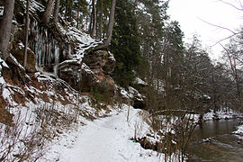
The gorge in winter, January 2013

Crumbling holes in the rock
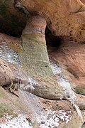
Rock column near Gsteinach
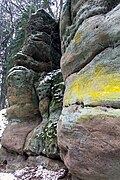
Play of colors in the rock
Source outlet near the Karlshöhle, July 2012
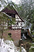
Gsteinach river power station


literature
- Brigitte Kaulich, Rolf KF Meyer, Hermann Schmidt-Kaler: Walks into the history of the earth, Volume 11: From Nuremberg through the Pegnitz-Alb to the Bavarian Eisenstrasse . (Series of publications by the Franconian Switzerland Association: The Franconian Switzerland - Local History Supplements 15). Publishing house Dr. Friedrich Keil, Munich 2000, ISBN 3-931516-76-8 , pp. 44-57.
Web links
- Location and extent of the nature reserve (accessed on May 1, 2013)
Individual evidence
- ↑ Geotope: Schwarzach Gorge near Schwarzenbruck (accessed on March 20, 2020)
- ↑ Schwarzach Gorge
- ↑ www.nuernberger-land.de Regulation of the nature reserve ( page no longer available , search in web archives ) Info: The link was automatically marked as defective. Please check the link according to the instructions and then remove this notice. (Accessed March 16, 2017)
- ^ Government of Middle Franconia, NSG Schwarzachschlucht (accessed January 29, 2013)
- ↑ Natura 2000: DE6633371, NSG 'Schwarzach-Durchbruch' and Rhätschluchten near Burgthann (accessed on June 22, 2013)
- ↑ Information panel Schwarzachschlucht (accessed on January 28, 2013; PDF; 2.4 MB)
- ^ Daily newspaper Der Bote, edition of March 28, 2014
- ↑ Press article, unobstructed view of the sewage treatment plant (accessed on January 28, 2013)


