
Schottental near Heldmannsberg
|
Schottental near Heldmannsberg
|
||
 The Schottental in autumn |
||
| location | Heldmannsberg , Middle Franconia , Bavaria , Germany | |
| surface | 45.1 ha | |
| Identifier | NSG500.054 | |
| WDPA ID | 165467 | |
| Natura 2000 ID | DE6534371 | |
| Geographical location | 49 ° 28 ' N , 11 ° 34' E | |
|
||
| Setup date | January 25, 1996 | |

The Schottental near Heldmannsberg is a nature reserve south of Heldmannsberg , a district of the Central Franconian municipality of Pommelsbrunn in Bavaria .
location
The Schottental nature reserve near Heldmannsberg is also called Schottenloch and is located on the eastern edge of the Nürnberger Land district and the border with the Amberg-Sulzbach district in Upper Palatinate . It is bounded in the north by the district road LAU28 and in the south by the state road St2236.
description
The valley is a designated, 41.5 hectare nature reserve and has the cadastral number NSG500.054. The nature reserve is part of the Natura 2000 network and designated as part of the protected area DE6534371, brook valleys of the Hersbrucker Alb .
It encompasses the valley floor and the slopes of a deeply carved side valley of the Albach valley. The near-natural Talbach meanders through the valley at the edge of the forest and flows into the Alfeld Bach immediately behind the southern border of the nature reserve. Several pot springs feed the Talbach and represent a scenic feature. There is also a small pond there. The slopes are now grazed with sheep based on the historical model , giving them the typical character of a Hutanger . There are dolomite rock heads near the valley floor . The most imposing of them is the Bärenfels, 427 meters above sea level.
Flora and fauna
In the valley floor there are species-rich, moderately intensively used and partly fallow meadows and pastures. On the steep slopes, mixed forests with beech and pine trees and limestone grasslands alternate with poor pastures. Dense sloe bushes and hedges also serve as bird breeding habitats . Ferns can be found on the shady sides of rocks . The open slopes with the limestone grasslands represent important habitats for butterflies and insects.
Surroundings
The surrounding area is also interesting. In addition to the beautiful Mariae Himmelfahrt church in Heldmannsberg, there was a hilltop settlement from the Bronze Age on the Zant mountain area to the east . A prehistoric cave station (D-5-6535-0103) and Mesolithic open - air stations (D-5-6535-0044, D-5-6535-0052) can be found near the Ameisenberg .
Access
The nature reserve is freely accessible all year round via some paths. A hiking trail (marked with a red circle on a white rectangle) crosses the valley. The best seasons for a visit are the leaf changes in spring and autumn, as well as early summer with the meadow blossoms. Parking is available on State Road St2236 and in Heldmannsberg. With the public transport ( VGN ) it is only possible to arrive during the week with the 336 bus to the Heldmannsberg stop. At the weekend you can take the R3 regional train from Nuremberg to the Hersbruck train station (on the right of the Pegnitz) or the Hersbruck S-Bahn line 1 (on the left of the Pegnitz), then take the 334 bus to Thalheim and then walk around 15 minutes.
Picture gallery

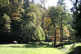
Valley floor in autumn
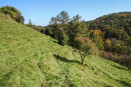
Limestone slope near Heldmannsberg in autumn

Slope meadow in summer

Nature reserve near the state road

Church of the Assumption of Mary in Heldmannsberg


Individual evidence
- ^ Government of Middle Franconia, Schottental nature reserve (accessed on February 1, 2013)
- ↑ Bavarian State Ministry of Environment and Health, NSG500.054 Schottental near Heldmannsberg (accessed on February 1, 2012)
- ↑ Natura 2000: DE6534371, Bachtäler der Hersbrucker Alb (accessed on June 22, 2013)
- ↑ Bodendenkmal D-5-6535-0089 (accessed on February 1, 2013)
Web links
- Holidays in the Franconian Alb, Schottental (accessed on February 1, 2013)
- Location and extent of the nature reserve (accessed on May 1, 2013)

