
Rinntal near Alfeld
|
Rinntal near Alfeld
|
||
 Dry valley with field terraces near Alfeld |
||
| location | Alfeld , Middle Franconia , Bavaria , Germany | |
| surface | 33.82 ha | |
| Identifier | NSG500.063 | |
| WDPA ID | 318994 | |
| Natura 2000 ID | DE6534371 | |
| Geographical location | 49 ° 26 ' N , 11 ° 33' E | |
|
||
| Setup date | September 8, 2000 | |

The Rinntal near Alfeld is a nature reserve north of Alfeld in the Middle Franconian district of Nürnberger Land in Bavaria .
location
The Rinntal near Alfeld borders directly on the northern outskirts of Alfeld. In the east it is bounded by the state road St 2236 and in the north by the connecting road to Pollanden .
description
The Rinntal is a designated, 33.8 hectare nature reserve and has the cadastral number NSG500.063. The nature reserve is part of the Natura 2000 network and designated as part of the protected area DE6534371, brook valleys of the Hersbrucker Alb .
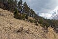
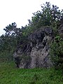
It is a typical Jura dry valley of the Alb plateau . The area includes the valley floor in east-west direction and the slopes of a side valley of the Albach. In the valley floor there is a dry creek channel that only carries water in heavy rain. The slopes were traditionally used as hutanger in the past and have been grazed with sheep again for several years . The valley floor is characterized by cultivated meadows and the flatter valley slopes are divided by former arable terraces. The associated tendrils are overgrown with patchy field hedges and rich in limestone fragments.

Flora and fauna

Today, juniper heaths and limestone grasslands with isolated small dolomite rocks in between characterize the landscape of the valley framed by pines . The valley is a valuable habitat for numerous butterflies .
Surroundings
The immediate area around Alfeld offers an extensive network of hiking trails and numerous karst caves .
Access
The nature reserve is freely accessible all year round. A circular hiking trail with informative boards leads along a designated nature adventure trail from Alfeld through the Rinntal. A visit is particularly worthwhile in early summer when the limestone grass is in bloom.
Picture gallery

Early spring

Valley near Alfeld
Typical hillside meadow
Rinntal with dolomite rocks in summer


Individual evidence
- ^ Government of Middle Franconia, nature reserve Rinntal near Alfeld (accessed on April 2, 2013)
- ^ Bavarian State Ministry of Environment and Health, NSG500.063 Rinntal near Alfeld (accessed on April 2, 2013)
- ↑ Natura 2000: DE6534371, Bachtäler der Hersbrucker Alb (accessed on June 22, 2013)
- ↑ Hiking trails around the NSG ( Memento of the original from November 29, 2015 in the Internet Archive ) Info: The archive link has been inserted automatically and has not yet been checked. Please check the original and archive link according to the instructions and then remove this notice. (Retrieved April 2, 2013)
- ↑ OpenStreetMap, course of nature trail (accessed April 2, 2013)
Web links
- Alfeld municipality, Rinntal nature experience (accessed April 2, 2013; PDF; 1.8 MB)
- Location and extent of the nature reserve (accessed on May 1, 2013)

