
Hutanger

The hutanger is a typical term for old pastureland in the Nuremberg region and the neighboring areas, which was grazed by the cattle of a village community and used to be part of the common land. A village shepherd was hired by the community to tend and care for the animals. As a hutanger, a traditional, Bavarian land use is referred to, which today represents a historical and landscape-defining cultural landscape element.
term
The term Hutanger is made up of the word Hut and the term Anger.
- Hat - comes from herding, guarding, herding animals - as in Hute (Hude), Hutung, Hutewald, Hutweide
- Anger - Old High German angar , West Germanic angraz means wild, ungepflügtes grasslands
The term (Hut-) Wasen is used in the area of Windsheimer Bucht and on the edge of the southern Steigerwald . Hutung , Hute, Hude and common are used as synonymous terms.
In addition, the term Espan is common in southern Germany for pastures close to villages that were grazed with cattle without a shepherd. Old field names bear witness to this historical form of land use.
Characteristic
General

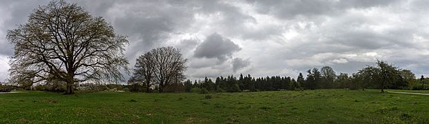
Today the areas can mostly be recognized by old trees spread out like a park. They are among the cultural landscape highlights of Bavaria and are witnesses of the former Franconian pastoral culture.
The hutanger areas were mainly grazed with cattle, but sheep, goats, horses, pigs and geese were also kept on the pasture areas. The grassland was mostly covered with oaks , more rarely with fruit trees , beeches , lime trees , spruces or pines .
Types
The hutanger can be divided into different types. The differentiation results from the different character of the areas due to their small-regional ties.
Irregular old oak hutanger

This type of Anger includes hutanger irregularly covered with old oaks, which are predominantly interspersed with other woody plants such as willow beech , willow hornbeam, field elm , birch , spruce and fruit trees.
They mostly arose from open pastureland near the village or, more rarely, from the historical use of the forest.
Regular oak hutanger
This type of Hutanger is characterized by the planned arrangement of the trees. In the 19th century, the trees were planted with a regular structure to achieve optimal acorn mast. The trees were planted at regular intervals, with the seedlings being of the same age. This type of Angert is closely related to orchards . The targeted and planned planting of individual trees has been sufficiently documented from the second half of the 20th century.
Spruce Hutanger

Centuries ago, free-standing and deep-branched umbrella spruce trees were planted on the plateau spurs of the southern Franconian Alb; these form the type of the spruce hutanger.
Example:
- Heuchlinger Anger (District of Nürnberger Land)
Mixed hutanger

Mixed hat tree ensembles emerged on the Jura sheep heaths and consisted of willow beech stocks with admixtures of birch, pine, spruce, rowan berries, hornbeam, linden and ash.
Examples:
- Klingenhofer Hutanger - Mixed Hutanger on a Jura plateau between Weißenbrunn and Offenhausen in the Püscheldorf district ( protected part of the landscape in the Nürnberger Land district )
- Hinterhaslacher Hutanger (protected part of the landscape in the district of Nürnberger Land)
Fruit trees
This type of Angert consists of stands of fruit trees, which on Hutangern were mostly planted on slopes. As early as the 16th century, there were fruit trees on tree pastures, which consisted of wild fruit until the 18th century . From the 19th century, cultivated fruit trees were planted specifically. The planting of fruit trees was mostly suggested by the village authorities. The fruit was also used jointly (common land). The distribution of the fruit took place according to different regulations. Either the fruit was distributed to the legal representatives of the village community, the trees released for harvest, auctioned or leased. In individual cases, self-planted trees could be used for life and passed into the common property after the death of the planter.
Example:
- Hersbrucker Alb
draft
Tratten are light, grove-like stands of deciduous trees with sycamore maple (Acer pseudoplatanus) as the dominant tree species and beech, elm, ash and linden tree as secondary tree species on mostly poor grassland undergrowth. A shrub layer is missing or only sparsely developed. These pastures were located in the immediate or nearer settlement area and mostly covered less than one hectare in size. The open spaces guaranteed a public path connection between the hamlets and farms. They were formerly in sovereign possession.
The meadows were grazed before and after the cattle drive, in spring and autumn. The farmers also had the usage rights for so-called Schwenden . The term is understood to mean the elimination of young growth under the sparse trees. Thus the pasture areas were kept open. Often the pastures were mowed once a year in late summer before the leaves fell. In this way, the autumn leaf litter extraction , the so-called Laabrecheln, was made easier. Sycamore maple has easily decomposable foliage, which makes it particularly suitable for leaf litter use. The thick trunks of the sycamore maple were also required for local woodworking. The change in the types of use of leaf litter extraction, mowing, pasture and wood extraction on the Tratten areas represents a typical regional adaptation to the specific site conditions of the Berchtesgadener Land. Due to the small amount of arable land, the lack of straw had to be compensated for. There were also hardly any litter meadows with usable wet grassland. The characteristic triple use of the tree-lined open spaces has lasted for centuries and is still practiced locally in the Berchtesgaden area today as an adaptation to the alpine terrain and the harsh climate.
Example:
- Scheffauer Tratte - Tratten as a typical element of the rural cultural landscape are limited to the Berchtesgaden area ( Berchtesgaden , Bischofswiesen , Ramsau bei Berchtesgaden and Schönau am Königssee ).
Landscaping features
Hutangers can have different landscape features:
- Triftweg (cattle drive),
- Cattle troughs and cattle resting places with shady trees,
- Track compartments,
- Reading stone walls (stone bar) as a boundary to neighboring alluvial areas and markings,
- Forest hedges, hedge trains and
- Ditches or weirs.
Flora and fauna
The hutanger are home to valuable habitats for many rare animal and plant species. The highest biodiversity is found in those Hutanger which offer a diverse mosaic of open land areas exposed to the sun and shaded locations. Deadwood beetles (xylobionte ) such as hermit (Osmoderma eremita), stag beetle (Lucanus cervus) and billybuck (Cerambyx cerdo) colonize caves in the deciduous trees of the Hutanger and use them as breeding trees. The painted lady (Vanessa cardui) finds suitable living conditions on the poor grassland (dry grassland) of this semi-open cultural landscape . The middle woodpecker (Dendrocopos medius) also uses the old biotope trees as a habitat. Old oaks with rough bark, a high proportion of crown deadwood and rotten areas offer suitable habitats for the endangered species of woodpecker. The wryneck (Jynx torquilla) breeds in the woodpecker holes and occupies this ecological niche .
distribution
Hutanger had been widespread throughout Bavaria since the Middle Ages. The main focus of the preserved areas is in the district of Nürnberger Land . The core area of the distribution area is the Hersbrucker Alb . This stock of Hutangers is unique in Germany.
In western Central Franconia there are also significant holdings of this historical cultural landscape element, three cultural landscape areas still have hutanger:
- Southern Steigerwald with foreland,
- Swiss franc amount and
- Windsheim Bay.
history
From the High Middle Ages to the 19th century, the agricultural areas were divided into corridors and common areas.
The corridor is a parceled agricultural area, mostly privately owned. In contrast, the common area comprises common agricultural areas that were grazed or were used for litter . The common land was used by authorized persons and not by a property allocation.
In addition to the classic village people and community people in the floodplain, hutangers were also used as common land , which were distributed in the corridor.
In the course of the Dreizelgenwirtschaft (three-field farming), farm animals in the village, such as cattle, pigs, geese and sheep, were only to be led through Hutzwang on the village's jointly organized hat pastures. The livestock had to be handed over to community-appointed shepherds at least during the core times of the growing season and were not allowed to be grazed individually by each farmer. The focus area of the unregulated Hut cattle pastures were grassland, which mostly comprised better pastureland near the village. With the introduction of the improved three-part economy through the abolition of the Hutzwangen in the period from about 1770 to 1850, the image of Central European cultural landscapes changed fundamentally. As a result, most of the hutangers in Central Europe were lost in the 18th and 19th centuries, even though this form of land use was practiced for centuries.
Todays situation
Hersbrucker Alb
On the Hersbrucker Alb there are still around 120 hutanger with a total area of around 500 hectares . Oak trees take up almost a quarter, around 60 hectares are fruit trees.
District Neustadt ad Aisch-Bad Windsheim
The majority of the hutanger in the Neustadt adAisch-Bad Windsheim district are hats that were put on for the acorn mast in the middle of the 19th century. The average size is around 3 hectares and with a few exceptions the area is less than 10 hectares. Two larger locations emerged from the medieval forest pasture . The Weigenheimer mold in the Steigerwald takes the character of Hutelandschaften with over 28 hectares.
Hazards
The frequent division of the Allemende areas was the main reason for the disappearance of this Angertype. The unprofitable management of the sites in the 20th century meant that many hutangers in Bavaria were abandoned and overgrown, developed as high forest or destroyed by reforestation measures. Settlement expansions and intensification of agriculture have fragmented and significantly decimated the once extensive stocks of this type of cultural landscape.
Others
The German Shepherd Museum is located in Hersbruck .
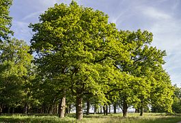
photos
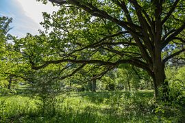
Mühlschlag Anger near Engelthal
Klingenhofer Anger
Eichenanger near Krönhof


See also
literature
- Rainer G. Schöller, Michael Scholz, Rainer Wölfel: Hutanger: Natural and cultural heritage with a future. Verlag Naturschutzzentrum Wengleinpark eV, 2005, ISBN 978-3-00-017137-6 .
- Bavarian State Office for the Environment (Hrsg.): Historical cultural landscape elements in Bavaria. In: Product information "Heimatpflege in Bayern, Issue 4. 2013, ISBN 978-3-931754-54-9 .
Web links
Individual evidence
- ↑ a b Hutanger. District Office Nürnberger Land, accessed on October 18, 2017 .
- ↑ a b c d e f g h i j k l m n o p Historical cultural landscape elements in Bavaria. In: Bavarian State Office for the Environment (Hrsg.): Heimatpflege in Bayern. Series of publications by the Bavarian State Association for Homeland Care . 1st edition. tape 4 , 2013, ISBN 978-3-931754-54-9 , pp. 98 f., 148 f .
- ↑ Ordinance on the protected landscape component "Klingenhofer Anger" from November 10, 1986. (PDF) District Office Nürnberger Land, November 10, 1986, accessed on October 22, 2017 .
- ^ Official Journal for the district of Nürnberger Land. (PDF) District Office Nürnberger Land, January 6, 2011, accessed on October 22, 2017 .
- ↑ a b Hutanger in the Hersbrucker Alb. (PDF) Bavarian State Ministry for the Environment, Health and Consumer Protection, 2006, accessed on October 18, 2017 .
- ↑ Project: Hutanger Project. Academy for Nature Conservation and Landscape Management (ANL), accessed on October 22, 2017 .
- ↑ The orchard meadow: The fruit trees. Streuobstinitiative Hersbrucker Alb eV, accessed on October 22, 2017 .
- ↑ Christoph Merker: Exhilaration in the Berchtesgadener Land: Of mountains, cows and people . Gmeiner Verlag, Meßkirch 2013, ISBN 978-3-8392-1472-5 , pp. 192 .
- ^ Draft of a cultural landscape structure of Bavaria as a contribution to biodiversity: 61 Berchtesgadener Land. (PDF) Bavarian State Office for the Environment (LfU), 2011, accessed on October 22, 2017 .
- ↑ UNESCO Biosphere Reserves: National Landscapes. (PDF) EUROPARC Germany e. V, 2007, accessed October 24, 2017 .
- ↑ Klaus Brünner and Klaus von Dunk: Further Franconian evidence of the hermit Osmoderma eremita (Col.), as well as comments on the reproductive dynamics with regard to habitat protection. (PDF) In: galathea 19/4: Reports of the Nuremberg Entomologists. Nuremberg Entomologists Circle, 2003, accessed October 15, 2017 .
- ↑ Hutanger pastures are "tidied up". Verlag Nürnberger Presse (nordbayern.de), December 10, 2013, accessed on October 15, 2017 .
- ↑ a b The oak tree. Naturschutzzentrum Wengleinpark eV, accessed on October 15, 2017 .
- ^ Contribution to the history of the grasslands of Central Europe. Nature conservation and landscape planning, May 2010, accessed on October 23, 2017 .
- ↑ Nature, Diversity, Middle Franconia. (PDF) Government of Middle Franconia, December 2008, accessed on October 17, 2017 .