
Pegnitzau between Ranna and Michelfeld
|
Pegnitzau between Ranna and Michelfeld
|
||
 Entrance to the nature reserve |
||
| location | Neuhaus an der Pegnitz | |
| surface | 198.41 | |
| Identifier | NSG-00548.01 | |
| WDPA ID | 318939 | |
| Geographical location | 49 ° 41 ′ N , 11 ° 33 ′ E | |
|
||
| Setup date | 1998 | |

The Pegnitzau between Ranna and Michelfeld is a nature reserve in the districts of Nürnberger Land , Amberg-Sulzbach and Bayreuth in Bavaria .
location
The total of 198.41 hectares of nature reserve is distributed as follows:
- District of Nürnberger Land, Middle Franconia with 99.34 hectares
- Amberg-Sulzbach district, Upper Palatinate with 79.83 hectares
- Bayreuth district, Upper Franconia with 19.24 hectares
The protected area is located in Markt Neuhaus an der Pegnitz , district of Höfen (district of Nürnberger Land), in the community-free area Veldensteiner Forst (district of Bayreuth) and in the town of Auerbach in the Upper Palatinate , districts of Ranna and Michelfeld (district of Amberg-Sulzbach).
The poorly developed Jura Valley is located east of the Veldenstein Forest , about four kilometers north of Neuhaus an der Pegnitz and is part of the Franconian Switzerland-Veldenstein Forest Nature Park .
description
The nature reserve was designated on March 19, 1998 by the Bavarian State Office for the Environment and has the cadastral number NSG-00548.01.
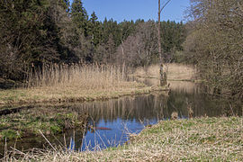
The landscape is shaped by the river Pegnitz and its extensive valley meadows. The Pegnitz meanders in a natural course over about eight kilometers through the valley. Spring pots , natural ponds and backwaters accompany the still young river there. The protected area is located largely within the water reserve Ranna, the drinking water supply of the metropolitan area Nürnberg by the Rannaleitung assured.
After the demolition of the localities Fischstein , Rauhenstein and Unterbrand , the local area Tiel became the nature reserve.
Flora and fauna
In the protected area there are wet meadows, fallow meadows , Großseggenriede and reed stands. The course of the river Pegnitz is accompanied by light alder and willow forests . In the south, extensive, extensively used meadows in gently rolling terrain belong to the protected area. They are bordered on the edges by warmth-loving fringes, grasslands and mixed deciduous and pine forests. The great variety of locations is the reason for the high biodiversity of plants, birds and butterflies.
Kammerweiher

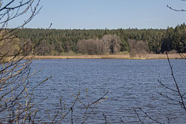
The two chamber ponds, each around 17 hectares in size, are located in the Upper Palatinate region and are of great importance for species protection . They are called Oberer Kammerweiher and Unterer Kammerweiher. The banks of the pond areas offer siltation zones of large sedge vineyards up to numerous alder forests dragonflies - and amphibians , newts , toads and frogs and the rare agile frog a suitable habitat.
The Bund Naturschutz has been looking after the Kammerweiher near Auerbach in Upper Palatinate since 1980. In a survey of the animal world by the Bund Naturschutz in 2002, over 60 different bird species were found, including 16 endangered species on the Red List. Many birds use the water surface as a resting and feeding place on the passage. In late summer, the ponds are lowered to provide mud flats for the wading birds ( Limikolen ). The extensive management of the ponds is the prerequisite for maintaining and increasing biodiversity. The fish population must be regulated by occasional fishing so that enough fish are available for food, and on the other hand the offspring of the amphibians (spawn and tadpoles that serve the fish as food) have a chance of survival.
There is a wooden observation tower between the two ponds.
Seeweihergrotte

The spring cave is a geotope and has a considerable amount of fill at normal water levels . When the underground karst water level rises, the spring pours water from the Seeweihergrotte into the lake pond. When the Pegnitz floods, on the other hand, the direction of flow is reversed and the water from the lake pond disappears in the mountain. It then acts as a curler ( ponor ). It is therefore a so-called Estavelle .
The spring cave is also designated as a natural monument and is listed as D 68 in the Franconian Alb cave register (HFA).
Owl hole

The owl hole is a karst cave that is designated as a geotope (472R136) and a natural monument. The small cave is about 15 meters long and is located in a rock at a height of about five meters. The cave is listed as D 66 in the Franconian Alb cave cadastre (HFA).
More geotopes
The following geotopes are also located in the nature reserve :
- Silberlochfelsen and Silberloch Cave (D69) WSW von Michelfeld (472R135)
- Rock grotto SW of Michelfeld (472R064)
- Rocks with sand wave caves (D211) SW of Michelfeld (472R137)
Access
The protection area is freely accessible and is criss-crossed by numerous cycling and hiking trails. Seasonally particularly worthwhile for a visit are the early summer with the flowering of the meadows or the autumn colors of the deciduous forests.
Picture gallery
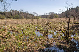
Wet meadow

Flood plain

Pegnitz in the NSG
Sea pond
Upper chamber pond


Individual evidence
- ^ Government of Middle Franconia, Pegnitzau nature reserve between Ranna and Michelfeld (accessed November 9, 2015)
- ↑ Ordinance on the Pegnitzau nature reserve between Ranna and Michelfeld ( Memento of the original from March 6, 2016 in the Internet Archive ) Info: The archive link was inserted automatically and has not yet been checked. Please check the original and archive link according to the instructions and then remove this notice. (Accessed November 14, 2015)
- ↑ Bavarian State Ministry of Environment and Health: Green List of Nature Reserves in Middle Franconia (accessed on November 9, 2015)
- ↑ Bund Naturschutz: Pegnitzaue nature reserve between Ranna and Michelfeld (accessed on November 9, 2015)
- ↑ Geotope: source exit Seeweiher (D68) WSW von Michelfeld (accessed on November 9, 2015)
- ↑ Geotope: Felsen mit Eulenloch (D66) SW von Michelfeld (accessed on November 10, 2015)
- ↑ Geotope: Silberlochfelsen and Silberlochhöhle (D69) WSW von Michelfeld (accessed on November 10, 2015)
- ↑ Geotope: Felsengrotte SW von Michelfeld (accessed on November 10, 2015)
- ↑ Geotope: rocks with sand wave caves (D211) SW von Michelfeld (accessed on November 10, 2015)
Web links
- Caveseekers, Seeweihergrotte ( Accessed November 5, 2015)
- Location and extent of the NSG in OpenStreetMap


Craimoos pond | Haberstein | Rooster felt at Mehlmeisel | Haidenaabtal and Gabellohe | Hirschberg- and Heidweiher in the Gabellohe | Knock at Obernsees | Mixed deciduous forest in the upper Aufsessal | Moosbachaue | Fichtelseemoor natural forest reserve | Nusshardt | Muschelkalkgebiet am Oschenberg | Pegnitzau between Ranna and Michelfeld | Steinachtal with little drawbar | Devil's hole | Dry slopes around Pottenstein
