
Rauhenstein (Auerbach)
|
Rauhenstein
City of Auerbach in the Upper Palatinate
Coordinates: 49 ° 39 ′ 47 ″ N , 11 ° 34 ′ 24 ″ E
|
|
|---|---|
| Height : | approx. 388 m above sea level NHN |
| Residents : | 0 |
_Oktober_2010_-_panoramio_(1).jpg) Rauhenstein
|
|
Rauhenstein was once a district of the Upper Palatinate town of Auerbach in the Upper Palatinate in Bavaria .
location
The abandoned village was about a kilometer north of Ranna at the foot of the Calvary. To the south there was a stop on the abandoned Ranna – Auerbach railway line (1903-1970). Today the area is part of the Pegnitzau nature reserve between Ranna and Michelfeld and is designated as a ground monument (D-3-6335-0035, D-5-6335-0012).
history
Rauhenstein was near the former trade route Nuremberg – Auerbach and was determined by a castle with a paint mill and a bronze factory . In 1243, Rauhenstein was first mentioned in a document as the seat of the knight Vavelin von Ruinstein . On January 17, 1410, the Count Palatine Johann gave the Auerbach citizen Heinrich Stromeyer ( Stromer von Reichenbach ) to build a new iron hammer near the so-called Stockwiese . The annual rent was four guilders. After Heinrich Stromeyer's death, his heirs sold the iron hammer to the Nuremberg citizen Endres Prünster in 1427 . Endres Prünster did not run the business himself, however. He hired hammer smiths. One of the first blacksmiths was probably called Rauh or Rauch . In addition to Vavelin von Ruinstein, the blacksmith could possibly also give the place its name. Another assumption goes back to the adjective rough , which means hairy, shaggy or shaggy.
The hammer mill stood apart and relatively defenseless and defenseless on the Pegnitz . The owner and operator therefore expanded it into a castle-like building. Castles used to be called stone . Rauhenstein therefore possibly means, Burg des Rauh or Burg des Rauch. For further protection, Prünster was allowed to move the property with a ditch and divert the water of the Pegnitz there. The moat is still largely preserved today. In 1570 the hammer mill was transferred to Michelfeld Monastery . In 1629 the factory was destroyed by the French and the Walloons . On May 23, 1641 the hammer burned down completely. According to the tax books between 1648 and 166 it is referred to as "öd". In 1700 the city of Auerbach built a mill on the same site, which was supplemented in 1721 with a hammer house and a tavern . In 1733 the place came completely into the hands of the Michelfeld Monastery. In the course of secularization , it was handed over to private hands in 1803. In 1818 the place became part of the newly founded community of Ranna together with Pech, Hunger and Lehnershof . As part of the regional reform, the previously independent municipality of Ranna and the associated settlements Hunger , Lehnershof, Rauhenstein and Rußhütte came to Auerbach on January 1, 1972 .
Ancient cultivated land had to be abandoned by its inhabitants. The reason for the dissolution of the village was the supply of the city of Nuremberg with drinking water. For a long time the water from the nearby Haselhof springs was no longer sufficient. New sources had to be tapped. For this the villages Fischstein, Oberbrand , Unterbrand and Rauhenstein had to be demolished. From 1970 to 1987 all twelve properties were demolished and the residents relocated.
Around 1800, the settlement consisted of eight houses and properties in which more than 70 people lived. The former hammer house was probably built in 1736 and demolished in 1988. The building was designated as an architectural monument by the Bavarian State Office for the Preservation of Monuments (D-3-71-113-108).
Today, only a weir system with a turbine house and a wayside shrine and a parking lot for hikers remind of the abandoned village on the Pegnitz. In 2007 for the earlier parish fair, a memorial plaque was unveiled on site by former residents. In 2016, excavations were carried out in the area of the former village on behalf of the water supplier N-ERGIE . Those in charge of the company wanted to know what was left in the ground after the demolition. According to a statement by the press officer, there were garbage deposits, various metal parts and tar-painted pits. Construction waste and metal components were disposed of. Soil studies were also carried out as part of this earthwork. The research showed the great and historically significant potential of such medieval mining locations in the Auerbach- Sulzbach - Amberg area.

Weir system with turbine house on the Pegnitz, 2015
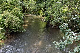
The Pegnitz near Rauhenstein

A Materl on the Pegnitz, 2019
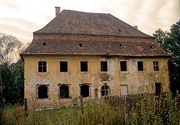
The demolished hammer house around 1987

Monastic coat of arms of Abbot Heinrich Hader (1736) on the former hammer house around 1987


Individual evidence
- ↑ BayernAtlas, Zeitreise, Rauhenstein around 1960 (accessed on June 3, 2019)
- ↑ Adjective rough at wiktionary.org (accessed June 4, 2019)
- ↑ Private website, http://www.weber-rudolf.de (accessed on June 4, 2019)
- ↑ a b www.onetz.de: Former Rauhensteiners unveil memorial plaque at the Kirchweih Festival - 20 years ago the end came back to the old homeland (accessed on June 4, 2019)
- ↑ BayernAtlas, historical map (accessed June 4, 2019)
- ^ Stefan Helml: Castles and palaces in the Amberg-Sulzbach district . Druckhaus Oberpfalz, Amberg 1991, pp. 178–179.
- ↑ On-site bronze plaque from the city of Auerbach, revealed in 2017
- ↑ nordbayern.de: excavators roll through the former town of Rauhenstein (accessed on June 4, 2019)
- ↑ The house of the medieval Hammerherren von Rauhenstein (accessed on June 6, 2019)
Web links

Auerbach in the Upper Palatinate | Bernreuth | Degelsdorf | Dornbach | Espa mill | Gunzendorf | Hagenohe | Hammerberg | Hämmerlmühle | Lehnershof | Guide | Intelligence | Michelfeld | Mühldorf | Nasnitz | Neumühle | Niedernhof | Nitzlbuch | Ohrbach | Ortlesbrunn | Horse rach | Ranna | Ranzenthal | Reichenbach | Rosenhof | Russhütte | Saass | Bag dilling | Sawmill | Sand | Bacon mill | Dust Hammer | Steinamwasser | Weidlwang | Welluck | Zogenreuth
Former districts: Rauhenstein